Check out our Holiday Auction

Forecast for the Logan Area Mountains

Toby Weed
Issued by Toby Weed on
Sunday morning, January 9, 2022
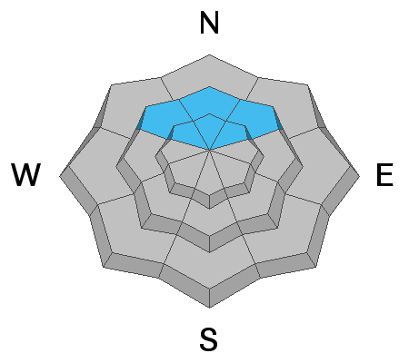
Heightened avalanche conditions and MODERATE danger exist on drifted upper and mid elevation slopes. Last week, drifting and tons of heavy snow overloaded north facing slopes plagued by a deeply buried persistent weak layer, and people still might trigger dangerous avalanches breaking 4 to 6 feet deep on sugary faceted snow near the ground in steep terrain above about 8000' in elevation. Heightened conditions also exist in steep exposed terrain at upper elevations, where people could trigger avalanches of wind drifted snow or cornice falls on drifted slopes facing any direction.
  • Evaluate snow and terrain carefully, and make conservative decisions.
Low
Moderate
Considerable
High
Extreme
Learn how to read the forecast here
Weather and Snow
About three feet of very heavy snow accumulated at upper elevations with last week's windy, wet, and warm storm. The 8400' Tony Grove Snotel reports 11°F this morning and there is 82 inches of total snow containing 163% of average SWE (snow water equivalent) for the date. The storm deposited over 8"of SWE at the site between Tuesday morning and Thursday night, which is an amazing amount. Winds out of the west are blowing around 20 mph this morning at the CSI Logan Peak weather station. Expect fair weather in the mountains today, continuing well into the middle of the week. High temperatures at 8500' will be around 28°F today and will drop to around 10°F tonight. A west wind around 10 mph will create wind chill values as low as -9°F.
It rained on the snow down low on Thursday, saturating the snowpack to the ground and creating runnels across the snow surface on all the slopes in mid Logan Canyon.
Carly sent in this picture of intense rain channeling on a slope in lower Bunch Grass. All slopes in the area now look like this....
Recent Avalanches
Numerous natural loose wet avalanches, entraining big piles of heavy snow occurred in Logan Canyon Thursday afternoon.

On Friday morning from Mendon I could see some natural activity involving wind drifted snow on the big east facing slopes of the Wellsville Range.
Heavy snow and wind drifting caused many natural avalanches to occur during last week's storm across the zone.

Check HERE for all the latest observations and avalanche activity.
Ad
Avalanche Problem #1
Persistent Weak Layer
Type
Location
Likelihood
Size
Description
I'm still avoiding steep north facing slopes at upper elevations where a person might trigger a dangerous deep slab avalanche breaking on a persistent weak layer near the ground. Although they have become much less likely and harder to trigger, very dangerous deep hard slab avalanches remain possible on northerly facing slopes above about 8000' in elevation. These slopes have a layer of weak, sugary facets near the ground that could fracture and produce slab avalanches 4-6 feet deep and hundreds of feet across. The danger of deep slab avalanches failing on a persistent weak layer is diminishing as the snow pack continues to deepen and gain weight, and the sugary faceted snow is compressed into the ground features. However in some isolated areas, ( in areas where the snowpack is shallower), avalanches on northerly facing slopes still might be triggered remotely, from a distance, or from flatter terrain under steep slopes.

Here is a more in depth discussion with UAC staff about persistent weak layers and slowly dropping danger ratings..
Avalanche Problem #2
Wind Drifted Snow
Type
Location
Likelihood
Size
Description
People could trigger slab avalanches of wind drifted snow in steep terrain at upper elevations today. Winds moderated yesterday and veered from the northwest for a while after days of blowing very strongly from the south and west, raking the fresh snow off windward slopes and depositing it in stiff drifts on the lee side of major ridges and in and around terrain features. Wind slabs and cornices will not be as sensitive today, and some could let a person get out on them before releasing like a mouse trap.
  • Large cornices could break further back than you expect, so you should stay well away from them, passing on the windward side of the ridge.
  • Cornice-falls could overload drifted slopes below and trigger large avalanches.
  • Avoid cornices and deposits of wind drifted snow in and around terrain features like sub-ridges, gullies, scoops, and cliff bands.
Additional Information
  • Always follow safe backcountry travel protocols. Go one person at a time in avalanche terrain, while the rest of your party watches from a safe area.
  • Check your avalanche rescue equipment, change your batteries, and practice often with your backcountry partners.
    Check slope angles and stay off of and out from under slopes steeper than 30° and adjacent slopes.
General Announcements
Who's up for some free avalanche training? Get a refresher, become better prepared for an upcoming avalanche class, or just boost your skills. Go to https://learn.kbyg.org/ and scroll down to Step 2 for a series of interactive online avalanche courses produced by the UAC.
  • Check out all the upcoming education classes and clinics HERE.
  • Please submit your observations from the backcountry HERE.
This information does not apply to developed ski areas or highways where avalanche control is normally done. This forecast is from the U.S.D.A. Forest Service, which is solely responsible for its content. This forecast describes general avalanche conditions and local variations always occur.