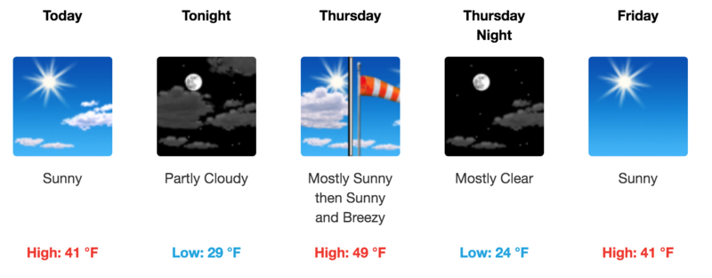
Forecast for the Abajos Area Mountains

Eric Trenbeath
Issued by Eric Trenbeath on
Wednesday morning, April 7, 2021
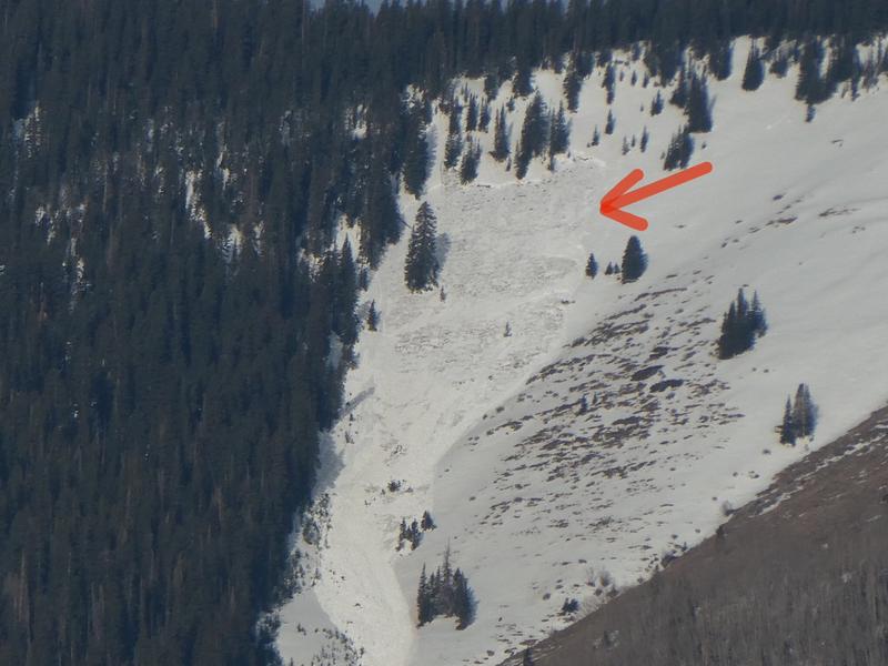
As the day heats up the danger for loose wet and wet slab avalanches will rise to MODERATE. Signs of instability include rollerballs, pinwheels, and punchy or sloppy unsupportable snow. Timing is everything. Work slopes according to their aspect and get off of and out from under steep slopes as they become wet and sloppy. With water moving through the snowpack, slopes do not have to be in the sun to be dangerous. Thin shallow rocky areas and terrain under cliffs should be avoided.
Low
Moderate
Considerable
High
Extreme
Learn how to read the forecast here
Special Announcements
Weather and Snow
Temps yesterday remained quite cool and overnight lows have dropped into the teens at upper elevations. Today look for sunny skies, light to moderate NW winds, and high temps near 40F. More of the same is on tap for the foreseeable future.
Overnight freezes and daytime high temps mean everything right now. Get current and past 24-hour readings from these real-time weather links.
Snow totals and temps at Buckboard Flat (8924')
Snow totals and temps at Camp Jackson (8858')
Snowpack Discussion
Two nights with a solid refreeze and overall cool temps yesterday have helped to lock up the snowpack and we're moving into what looks to be an extended corn cycle. This morning we'll see a solid, supportable crust that will gradually soften with the sun. The problem is finding a south aspect that hasn't melted out. Work the aspects starting with SE around 10:00 and end up on W around noon. North aspects remain in transition. Once the crust becomes unsupportable and the snow starts to get sloppy, it's time to call it a day as the danger for loose wet, or even wet slab avalanches will start to develop.
Recent Avalanches
Kevin Dressel spotted this wet slab avalanche from his back porch. This is a large avalanche failing to the ground.
Avalanche Problem #1
Wet Snow
Type
Location
Likelihood
Size
Description
Loose Wet Avalanches:
The danger for loose wet avalanches will rise today as the sun melts and softens the surface crust. Signs of instability include rollerballs, pinwheels, and "point release" sluffs that fan out and gather more snow as they travel down the slope. Timing is everything this time of year. Work slopes according to their aspect in relation to the sun and get off of steep slopes as they become wet and sloppy.
Wet Slabs:
Record temps and light to no overnight re-freezes a few days ago produced wet slab avalanches. This type of wet snow avalanche is harder to predict than loose wet it but can be invariably more dangerous. Wet slabs release when melt water saturates a layer in the snowpack and the over riding slab fails as a cohesive layer. Outward signs of this type of problem are not obvious but sloppy, wet, or punchy snow indicates that the pack is trending towards unstable. With water moving through the snowpack, slopes do not have to be in the sun to be dangerous. Thin shallow rocky areas and terrain under cliffs should be avoided.
Additional Information
Information on outdoor recreation - The State of Utah created this webpage with information about recreating on both state and federal public lands during the current health crisis.

New to the backcountry (including riding at closed resorts) - Watch the award-winning, 15 minute Know Before You Go video, or take the 5-part, free online-learning series.
General Announcements
This forecast is from the U.S. Forest Service, which is solely responsible for its content. This forecast describes general avalanche conditions and local variations always occur.