Forecast for the Abajos Area Mountains

Eric Trenbeath
Issued by Eric Trenbeath on
Monday morning, April 5, 2021
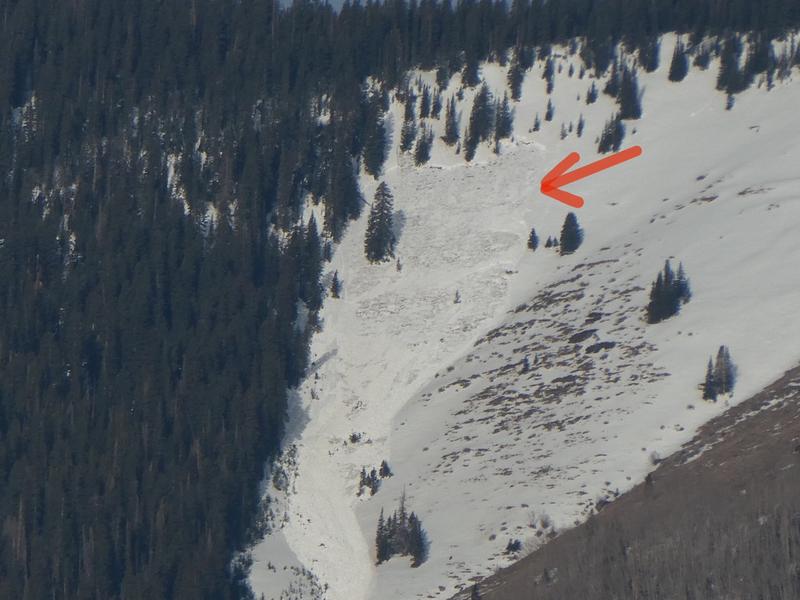
It did not freeze again last night and soaring temperatures will cause the danger for loose wet and even wet slab avalanches to quickly rise to CONSIDERABLE on all sun-exposed slopes. Signs of instability include rollerballs, pinwheels, and punchy or sloppy unsupportable snow. Stay off of and out from under steep slopes as they become wet and sloppy.
Low
Moderate
Considerable
High
Extreme
Learn how to read the forecast here
Special Announcements
Weather and Snow
Overnight freezes and daytime high temps mean everything right now. Get current and past 24-hour readings from these real-time weather links.
Snow totals and temps at Buckboard Flat (8924')
Snow totals and temps at Camp Jackson (8858')
Snowpack Discussion
Last night was our warmest night yet and the great melt-out continues. Expect punchy, unsupportable conditions this morning that will quickly become wet and sloppy. The snowpack is in a volatile state with melt-water running through it. Natural, wet slab avalanches running to the ground have occurred in both the La Sal and Abajo mountains. In addition to being dangerous, riding conditions just aren't very good. A solid freeze tonight should lock things back up and we will see a return to corn snow conditions for the remainder of the week. Go ride your bike or ATV today.
Recent Avalanches
Kevin Dressel spotted this wet slab avalanche from his back porch. This is a large avalanche failing to the ground.
Avalanche Problem #1
Wet Snow
Type
Location
Likelihood
Size
Description
Loose Wet Avalanches:
The danger for loose wet avalanches will again quickly rise today as a strong sun melts the thin surface crust. Signs of instability include rollerballs, pinwheels, and "point release" sluffs that fan out and gather more snow as they travel down the slope. Timing is everything today, and you need to get off of steep slopes as they become wet and sloppy.
Wet Slabs:
Record temps and light to no overnight re-freezes has produced wet slab avalanches. This type of wet snow avalanche is harder to predict than loose wet it but can be invariably more dangerous. Wet slabs release when melt water saturates a layer in the snowpack and the over riding slab fails as a cohesive layer. Outward signs of this type of problem are not obvious but sloppy, wet, or punchy snow indicates that the pack is trending towards unstable.
Additional Information
Information on outdoor recreation - The State of Utah created this webpage with information about recreating on both state and federal public lands during the current health crisis.

New to the backcountry (including riding at closed resorts) - Watch the award-winning, 15 minute Know Before You Go video, or take the 5-part, free online-learning series.
General Announcements
This forecast is from the U.S. Forest Service, which is solely responsible for its content. This forecast describes general avalanche conditions and local variations always occur.