A couple more inches of snow has trickled in since yesterday bringing totals since Tues up to around 8". Today look for increasing clouds as the next Pacific trough moves in off the coast and into the Great Basin. Light snow showers should develop mid-morning with 1"-2" possible today. SW winds will blow in the 15-25 mph range with high temps in the mid to upper 20's. Snowfall will increase tonight with another 3"-7" possible. Snow showers should linger through Friday followed by a building ridge of high pressure and sunny skies on Saturday.
Snowpack Discussion
3-5" of new snow yesterday with moderate NNE winds overnight has likely resulted in numerous shallow wind slabs in wind-exposed terrain at higher elevations. Yesterday in the La Sals in more wind-sheltered areas, I observed a variety of surfaces that the new snow has fallen-on. On southerly aspects, I encountered a supportive-crust and on well-shaded, northerly aspects, I observed soft snow containing some graupel in the uppermost layers. A couple of shovel-tilt-tests informed me that some of these layers are not bonding very well and it will be interesting to see how new snow and/or wind-drifted snow will bond with these surfaces.
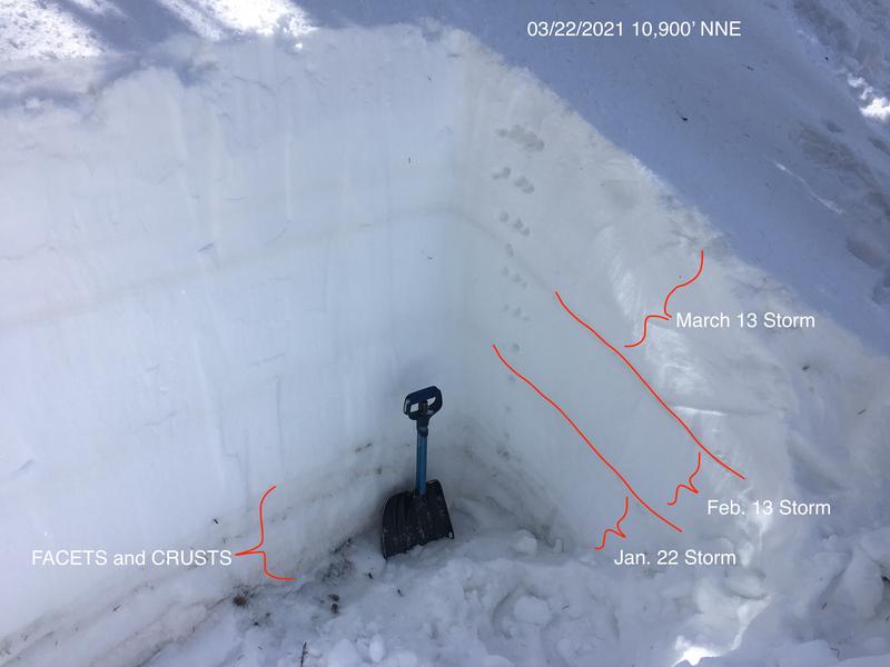
On Monday, Snowpack tests revealed that we still have a poor snowpack structure, but suspect weak layers are far-enough down in the snowpack that it will be difficult to affect them. Last week's storm appears to be bonding well to the old snow. Time and warm temperatures have helped stabilize the snowpack but it is still possible to trigger a deep and dangerous avalanche on a buried persistent weak layer of sugary, faceted snow. This weak layer exists on slopes that face NW-N-E, and thin snowpack areas consisting of steep, rocky terrain are the most likely trigger points. Here is a snapshot of the snowpack near Cooley Pass.