Forecast for the Abajos Area Mountains

Eric Trenbeath
Issued by Eric Trenbeath on
Thursday morning, March 19, 2020
Heads up folks, the avalanche danger has risen to CONSIDERABLE and human triggered avalanches involving new and wind drifted snow are likely. Signs of instability include recent avalanches, sluffing, and cracking in the snow surface. On steep, northerly facing slopes, human triggered avalanches failing on a buried persistent weak layer of loose, sugary, faceted snow are also possible. Whumphing and collapsing indicate this type of instability. Backcountry travelers need to have excellent route finding skills today. Stick to low angle, wind-sheltered terrain.
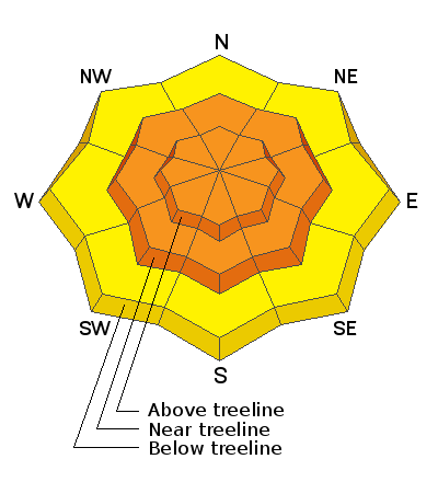
Low
Moderate
Considerable
High
Extreme
Learn how to read the forecast here
Special Announcements
We know there is a lot of uncertainty regarding the Coronavirus, but the Utah Avalanche Center is planning to continue issuing regular avalanche forecasts into April.
Weather and Snow
Camp Jackson and Buckboard Flat are both reporting 10" of new snow this morning so expect to find well over a foot up high. Strong SE winds that have plagued us for nearly a week finally backed off around midnight and have shifted to more westerly. Snowfall should continue this morning though it looks to taper off by around noon. 2"-4" more are possible. SW winds will blow in the 15-20 mph range with gusts into the 30's. High temps will be in the upper 20's. Unsettled weather will keep us under mostly cloudy skies with a chance of snow through Saturday. We'll see brief ridging on Sunday before the next Pacific low begins its trek into our region Mon-Tue.
Snow totals at Buckboard Flat (8924')
Snow totals at Camp Jackson (8858')
General Announcements
This forecast is from the U.S. Forest Service, which is solely responsible for its content. This forecast describes general avalanche conditions and local variations always occur.