Overnight SW winds picked up ahead of the next trough of low-pressure diving across the Great Basin. Today look for increasing clouds and blustery southwest winds with a chance for snow developing this afternoon and into the evening. Points north and those areas favored by NW flow will see the best chance for snow. Winds will shift to the NW as the trough passes through and temps will plummet into the single digits. Sunday should be dry and clear with breezy NW winds. Conditions remain dry through Tues with a slight chance for snow brewing Tues night into Wed.
Snowpack Discussion
It was a beautiful day in the mountains yesterday and my partner Kevin Dressel and I took advantage of the last day for powder snow on southerly aspects. By afternoon the strong sun and warm temperatures moistened the snow surface and sun-exposed slopes will be crusted over today. Plenty of soft dry powder remains on sheltered, northerly aspects, but you still need to keep your slope angles under 30 degrees to avoid triggering an avalanche. Buried persistent weak layers of loose, sugary snow exist deep in the snowpack and storm snow from last week has added stress to these weak layers. Fresh deposits of wind drifted snow today will add further stress.
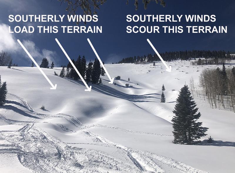
Photo below illustrates the type of terrain that should still be avoided. Slope is: 1) steep 2) subject to wind loading 3) northerly facing and therefore harboring layers of weak, sugary, faceted snow.
Under the current conditions, tickling slopes from below can cause avalanches to release from above.
No new avalanche activity has been observed since Brian Murdock reported this
avalanche on Horse Head Mountain on Monday. It likely ran naturally sometime during the storm last weekend.