Forecast for the Abajos Area Mountains

Eric Trenbeath
Issued by Eric Trenbeath on
Friday morning, December 31, 2021
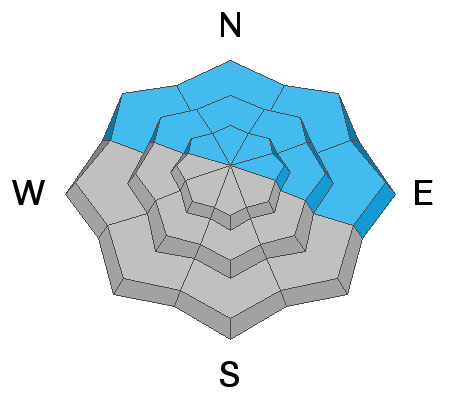
The avalanche danger remains CONSIDERABLE on steep, mid and upper elevation, wind drifted slopes that face NW through E and human triggered avalanches are likely in these areas. Be alert to changing conditons and signs of increasing instability such as cracking and collpasing in the snowpack, and developing recent deposits of wind drifted snow.
The avalanche danger is MODERATE on low elevation northerly aspects and on mid and upper elevation slopes facing the south side of the compass where you can detect recent deposits of wind drifted snow.
It's also still very low tide out there. Beware of rocks, stumps, and deadfall lurking beneath the surface.
Low
Moderate
Considerable
High
Extreme
Learn how to read the forecast here
Weather and Snow
Get current and past 24-hour readings from these real-time weather links.
Snow totals and temps at Buckboard Flat (8924')
Snow totals and temps at Camp Jackson (8858')
The strom system is on our door stop with 4"-8" possible accompanied by moderate to strong southwest winds. Snow showeres should linger into this evening with another couple of inches possible after sunset. High temps today will be in the mid 20's. Tonight winds will back off and shift to the NW and temps will plummet into negative territory. New Year's Day will see cloudy skies and a chance for scattered snow showers, blustery NW winds, and frigid temps in the single digits. Sunday will be cold, clear, and sunny.
Snowpack
Snow totals are up to between 12" and 15" since last Friday night with locally higher amounts at upper elevations. Coverage prior to this storm cycle was quite thin with most sun and wind exposed slopes still showing lots of grass and occasional patches of bare ground. Northerly facing slopes above about 9500' have held snow since October, and this old snow has formed a weak, sugary, faceted layer at the base of the snowpack and this is where the trouble is. Recent and wind drifted snow has formed a dense slab over top of this weak, sugary snow and human triggered avalanches on steep, wind drifted slopes that face NW through E are likely. On slopes facing W and SE you may find unstable deposits of wind drifted snow. Wind drifts are recognizable by their smooth, rounded appearance and cracking is a sign of instability.
Avalanche Problem #1
Persistent Weak Layer
Type
Location
Likelihood
Size
Description
A classic setup of strong snow over weak snow is developing on upper elevation, northerly aspects that retained snow from October. This October snow has become loose, weak, and sugary, or as we say, faceted. This faceted snow has formed a persistent weak layer at the base of the snowpack. Recent and wind drifted snow has formed a dense slab on top of this weak snow creating an unstable situation, and human triggered avalacnhes up to 2' deep are likely on steep, northerly facing slopes at mid and upper elevations.
Photo illustrates a cohesive slab from the Dec 10 storm sitting on top of loose, weak, sugary faceted snow from October.
Avalanche Problem #2
Wind Drifted Snow
Type
Location
Likelihood
Size
Description
Blowing and drifting snow has formed new wind slabs on leeward slopes that face primarily NW through E, but the gusty, erratic behavior of the winds may have deposited snow on a variety of aspects. Look for fresh drifts on the leeward sides of terrain features such as sub ridges, gully walls, and rock outcroppings. Fresh drifts are recognizable by their smooth, rounded appearance, and cracking is a sign of instability. On northerly aspects, wind drifted snow has added stress to older slabs on top of a buried persistent weak layer and dangerous, human triggered avalanches 2'-3' deep are possible. Avoid steep, wind drifted slopes, especially those that face the north side of the compass.
General Announcements
Who's up for some free avalanche training? Get a refresher, become better prepared for an upcoming avalanche class, or just boost your skills. Go to https://learn.kbyg.org/ and scroll down to Step 2 for a series of interactive online avalanche courses produced by the UAC.
This forecast is from the U.S. Forest Service, which is solely responsible for its content. This forecast describes general avalanche conditions and local variations always occur.