Observer Name
UAC Staff
Observation Date
Friday, January 8, 2021
Avalanche Date
Friday, January 8, 2021
Region
Salt Lake » Park City Ridgeline » Dutch Draw
Location Name or Route
Dutch Draw - Final Accident Report
Elevation
9,800'
Aspect
East
Slope Angle
39°
Trigger
Skier
Trigger: additional info
Unintentionally Triggered
Avalanche Type
Soft Slab
Avalanche Problem
Persistent Weak Layer
Weak Layer
Facets
Depth
2'
Width
150'
Vertical
400'
Caught
1
Carried
1
Buried - Fully
1
Killed
1
Accident and Rescue Summary
A 31-year-old male snowboarder from Clinton, Utah, was killed in an avalanche in Dutch Draw area off of Silver Peak. The snowboarder was riding with a skier, and neither of them was carrying any avalanche rescue gear. The pair was riding in the Canyons Village area of the Park City Mountain Resort, where they took four chair lift rides, ultimately bringing them to the top of the 9990 chairlift around 9:40 a.m. They hiked a short distance to access the Dutch Draw area at the top of the chairlift via the backcountry exit gate. From this gate, they left the ski area boundary, entered into the backcountry, and followed a ridgeline to the top of Silver Peak.
At the top of the Silver Peak, the rider began his descent of a slope called Conehead. When the snowboarder was midway down the slope, the skier started her descent. After making two turns, the avalanche broke at her feet, and the snowboarder was still midway down the slope where he was caught, carried, buried, and died from the avalanche. The skier was not caught in the avalanche.
Other avalanches along the Park City Ridgeline in the last week have been triggered remotely from ridegtops while others have been triggered by people low on slopes. It cannot be determined how this avalanche was triggered. It is likely that this avalanche was triggered by at least one of the two people on the slope or possibly by both.
Photo of avalanche path with skier’s tracks entering the crown. The avalanche crown to looker's right was triggered with explosives.

Photo of the entire avalanche path from the bottom, looking upwards from the debris.

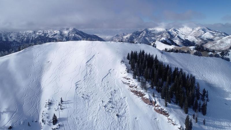
Aerial image of the slide path, the left-most crown is the human triggered avalanche. The right-most crown was explosive triggered.
Rescue
The skier who was not caught in the avalanche called 911 at 10:09 a.m. and 911 dispatch notified PCMR patrol, who then requested air support. In addition to the skier, there was a party of two and a party of one who had been riding in the area. Helicopters from the Utah Department of Public Safety (DPS) and AirMed responded. A helicopter from Lifeflight was also in the air and available if needed. The skier was transported from the scene via the DPS helicopter, and the other three people left on foot. Once the scene was clear, explosives were dropped from the DPS helicopter and triggered one avalanche to the looker’s right of the original avalanche.
Following the explosive work to make the scene safe from additional avalanches, rescue personnel from Summit County Search and Rescue, Park City Mountain Ski Patrol, the Park City Fire District, and Wasatch Backcountry Rescue arrived on the scene. An initial search was done with avalanche transceivers and a RECCO detector, but the snowboarder was found with an avalanche rescue dog. He was buried 2 feet deep and dug out of the debris at 2:30 p.m. His snowboard was still attached to one foot while his other foot had been pulled out of his boot. No obvious signs of significant trauma were reported.
Photo of the recovery location, looking up at the slide path above.

The Park City Ski Patrol searched the debris for signs of any additional burials using avalanche transceivers, a RECCO detector, and the dog team. Witness accounts and the number of tracks on the slope also helped confirm there was only one burial.
Terrain Summary
The Dutch Draw slope has been the scene of fatal avalanches in December 2019, February 2012, and January 2005.
The initial open slope of the ridge is about 30-32 degrees in steepness. It would appear to be relatively benign terrain to an advanced skier or snowboarder. Following a blind rollover, a short distance from the summit, the slope steepens to 38-40 degrees where the avalanche crown was located.
Photo of the terrain and slide path. The map below from the Wasatch Backcountry Skiing Map
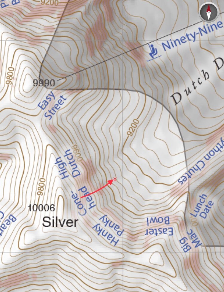
Classification for this avalanche is SS-AS/AR-R2-D2-O
Avalanche crown slope angle: 39 degrees
Burial location: 40.653056, -111.590278
Avalanche Width: 150 feet
Avalanche Length: 600 feet
Alpha angle: 32 degrees
The vertical drop of the avalanche was approximately 400 feet. The snowboarder was carried approximately 200 vertical feet.
The short video from December 2019 below shows the backcountry gate's view at the top of the 9990 chairlift, where you exit the ski resort boundary and enter the backcountry.
Weather Conditions and History
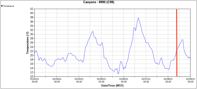
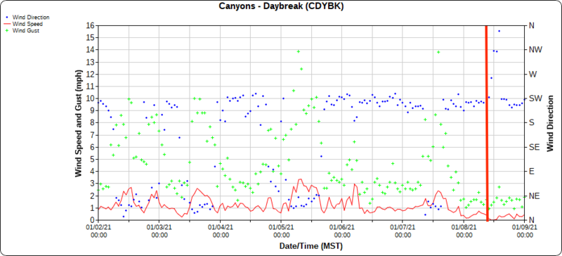
On the day of the accident, skies were partly cloudy, winds were generally light and westerly, and temperatures were in the mid-20s F.
In the week leading up to the accident, there were two small storms, and many human triggered avalanches in the area. Storm 1 on January 3rd brought 1-4 inches of new snow and moderate winds out of the southwest at upper elevations. The following day on January 4th, a human-triggered avalanche occurred about 2 miles north of the 9990 chairlift in the backcountry on a slope called Sound of Music, an east aspect at 9,200'. Storm 2 on January 5th brought 8-10 inches of new snow (containing 0.75 - 0.9 inches of water) with moderate to strong westerly winds. That day, 10 human-triggered avalanches were reported to the UAC. On January 6th and 7th, nine human triggered avalanches continue to be reported. Almost all activity involved avalanches failing in weak, faceted snow now buried 1-2.5 feet deep.
A look at the weather the 30 days leading up to the accident:
The two charts below show the wind and temperatures 7 days before the accident from the 9990 weather station which is approximately 1/3 mile NNW of the accident. Vertical red line is approximately the time of the accident.
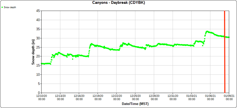
The three charts below show the temperatures and winds for 7 days before the accident, and total snow depth for 30 days before the accident from the Daybreak weather station which is approximately 1 mile SE of the avalanche. Vertical red line is approximately the time of the accident.
Comments
Snowpack
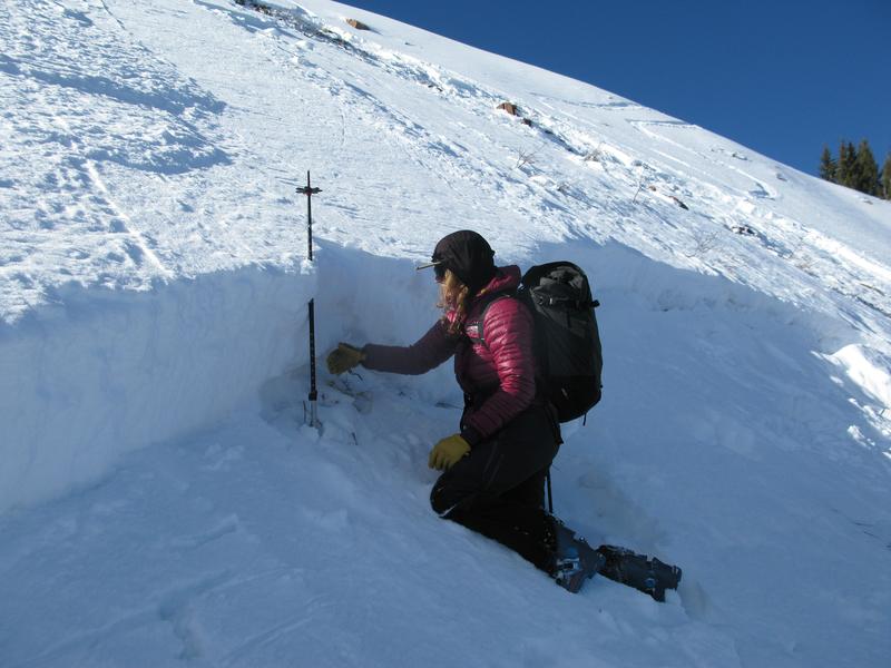
We dug a snowpit on a safe representative slope nearby and found a snowpack structure that has been seen widespread across the Park City Ridgeline. The layers shown in our snowpit profile were similar to the ones in the crown of the avalanche.
Snowpit profile below. The red line indicates the weak layer on which the avalanche fractured.

The layer of concern is a varying thickness layer of facets sitting on top of a melt-freeze crust that likely formed during the end of November and the beginning of December. This facet crust interface has been seen widespread across the Park City Ridgeline. The avalanche failed within the weak facets sitting atop the supportable melt-freeze crust. The avalanche initially failed mid-slab in some places, stepping down to the melt-freeze crust, but did not step all the way into the facets at the ground in any places on the crown or slide path.
Photo of the crown. (Photo: A. Van Houten)
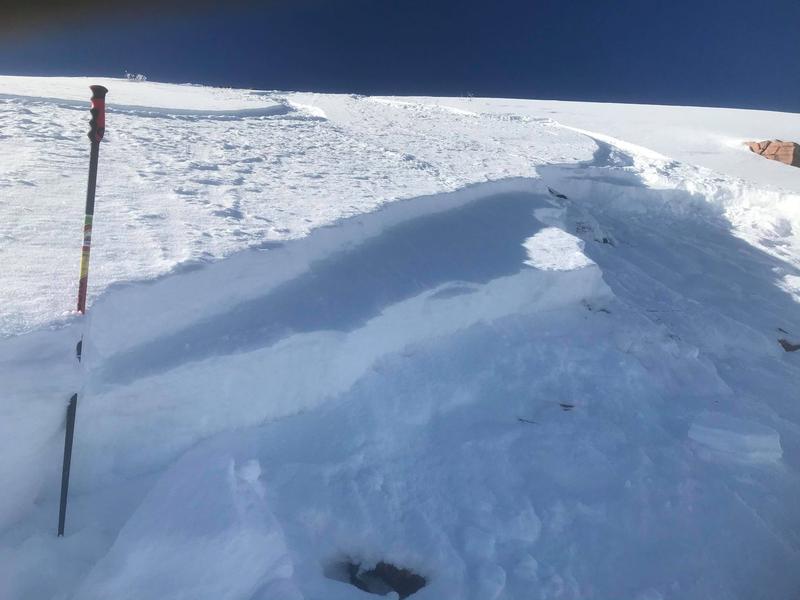
Photo showing crown depth lower on the slope where the avalanche had more uniformly broken in the facets on the top of the supportable melt-freeze crust.
Avalanche Danger
On the day of the accident, the avalanche danger was rated CONSIDERABLE on the slope where this avalanche occurred. Friday's avalanche forecast is available HERE.
Photo showing the forecast trend leading up to Friday.

On Saturday, January 9th UAC Forecasters Nikki Champion, Trent Meisenheimer, Craig Gordon and PCMR Snow Safety Team Members visited the site.
Our deepest condolences go out to the friends, family, rescuers, and everyone affected by this tragic accident.
Coordinates


