Forecast for the Uintas Area Mountains

Craig Gordon
Issued by Craig Gordon on
Friday morning, February 14, 2025
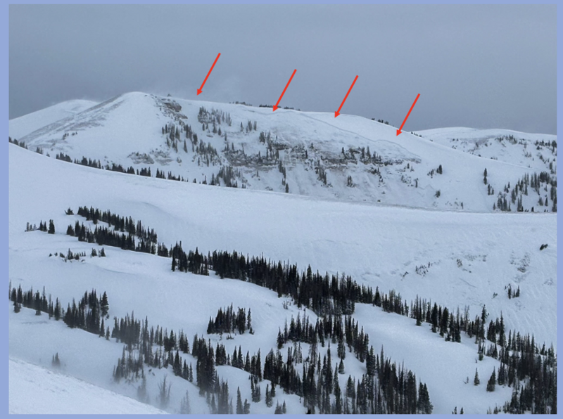
This is absolutely the real deal... the walls are officially caving in... it's Valentines Day and there's nothing romantic about not coming home to our families tonight... so let's not screw this up-
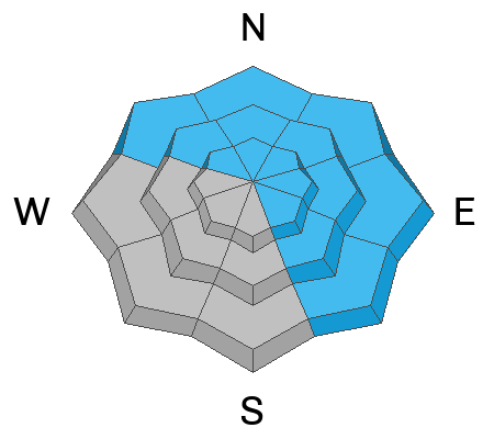
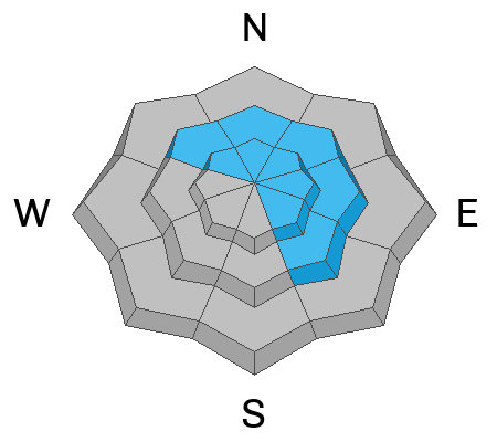
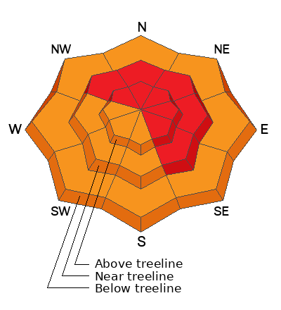
HIGH avalanche danger exists on mid and upper elevation slopes facing the north half of the compass. Both natural and human triggered avalanches are VERY LIKELY. Any avalanche triggered today is gonna result in a large, dangerous, UNSURVIVABLE, tree snapping, we don't come home to our family kinda avalanche.
Even lower elevations get in on the act where you'll find CONSIDERABLE avalanche danger and human triggered avalanches are LIKELY.
Avalanche conditions are SUPER SKETCHY-
We wanna see you getting out and enjoying this amazing storm but most importantly, we wanna see all of our backcountry family come home safely at the end of the day.
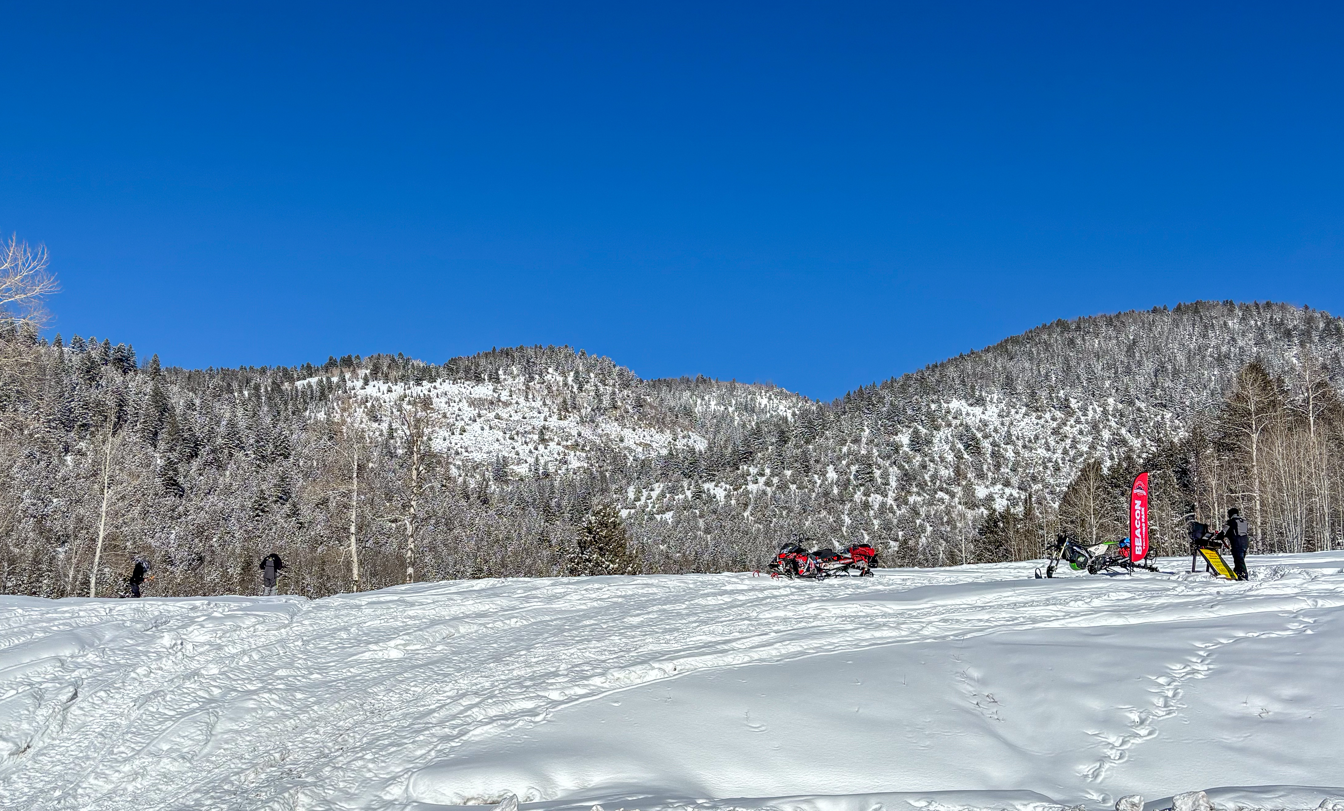
So here's our exit strategy... we can ride safely today by choosing miles and miles of big open meadows, far away from avalanche runout zones, and with no overhead hazard... that means no steep slopes above or adjacent to where we're riding.
Low
Moderate
Considerable
High
Extreme
Learn how to read the forecast here
Avalanche Warning
What- The avalanche danger for the warning area is HIGH today and may rise to EXTREME in some areas this weekend.
When- Very dangerous avalanche conditions are expected through the weekend.
Where- For all the mountains of Utah and Southeast Idaho, including the Wasatch Range, Bear River Range, Uinta Mountains, Wasatch Plateau, Manti Skyline, the La Sal Mountains, the Tushar Range....
Impacts- Heavy snow and drifting by strong winds have created widespread areas of unstable snow and very dangerous avalanche conditions at all elevations. Natural and human-triggered avalanches are likely. People should avoid travel in all avalanche terrain and keep out of avalanche runouts. This means you should stay off of and out from under slopes steeper than 30 degrees.
Weather and Snow
Nowcast- Over-the-hood and over-the-head... February's Snow Moon delivers! Now, let's do the overnight numbers- Upper Currant Creek 15" snow/1.7" H20, Mirror Lake Corridor 11"/1.4" H2O, Chalk Creek 12"/ 1.3" H20 and it's still puking snow. Southwest winds blow in the 40's as temperatures climbed into the 20's overnight.
Forecast- West to southwest flow continues to light up the Uinta's, delivering another good round of snow, water, and wind. My hunch is an additional 10" of snow stacks up with over an inch of SWE. It'll be warm with temperatures climbing into the high 20's. Southwest winds blow in the 30's along the ridges and crank in 50's near the peaks. A blast of cold air tonight brings in lower density snow to finish off the storm.
Futurecast- Look for a brief break in the action as high pressure builds into the area later Saturday into early Sunday. Another winter storm slides into our zone Sunday afternoon.
Here we go. Our longtime partners at the City of Salt's National Weather Service issued a Winter Storm Warning for the western Uinta Mountains.
Recent Avalanches
Meaty, beaty, big, and bouncy... the Uinta's came alive midday Thursday with an uptick in winds. Andy Nassetta is on a nearby ridge and literally watches the dust settle as a hanging snowfield in Upper Mill Fork delivers a massive 1200’ wide, 2'-10’ deep, very connected, tree snapping, drainage crashing, naturally triggered, Uinta-kinda avalanche.
Get up to speed by checking out obs, avalanches and trip reports from across the range and beyond, here!
Ad
Avalanche Problem #1
Persistent Weak Layer
Type
Location
Likelihood
Size
Description
These are the kind of conditions that kill riders so there's no reason to second guess, try to outsmart, or thread the needle on this one. Avalanches are breaking to the dirt. Slopes facing the north half of the compass are bullseye terrain.
The good news is... the coverage is absolutely remarkable and there's miles and miles of terrain to ride without even having to put ourselves at risk. Avoidance is key right now and all the avy-savvy folks I know are simply avoiding terrain where the problem exists and still get in a great day of riding. Done and done!
Avalanche Problem #2
Wind Drifted Snow
Type
Location
Likelihood
Size
Description
24 hour data dump from Windy Peak (10,661')
Yesterday's winds began nuking earlier than expected, changing the landscape, and forming drifts in unusual locations... and that was even before it began snowing! Now with storm snow available to work with, drifts are widespread and found tip to tail and cross-loaded in chutes and gullies and lower downslope than you might expect. Ya gotta be on your game today and avoid any fat looking rounded pillow of snow, because once initiated, it'll break deep and wide.
Avalanche Problem #3
New Snow
Type
Location
Likelihood
Size
Description
Generally, new snow instabilities are pretty straight-forward and begin stabilizing rather quickly. The curve ball here is that there is a ton of new snow even at lower elevations like around our cabins and foothills. So... we need to avoid travel under steep slopes even if we're taking the dog out for a walk, trail running, or snowshoeing.
Additional Information
The UAC Avalanche Transceiver Training Park is rocking and rolling at the Nobletts trailhead. Break out your gear, dust off your backcountry partners, and sharpen your perishable rescue skills with some practice!
General Announcements
We are always looking for snow and avalanche observations or just general riding conditions. In the meantime reach out to us with questions, concerns, or if you see anything in your travels! Contact us directly through the info below:
  • Craig Gordon | Craig@utahavalanchecenter.org, 801-231-2170, or
  • Andrew Nassetta | Andy@utahavalanchecenter.org, 860-460-8142.
This forecast is from the U.S.D.A. Forest Service, which is solely responsible for its content. This forecast describes general avalanche conditions and local variations always occur. This forecast was issued on Friday, February 14th at 04:30AM and expires 24 hours after it was issued.