Forecast for the Ogden Area Mountains

Trent Meisenheimer
Issued by Trent Meisenheimer on
Saturday morning, December 21, 2024
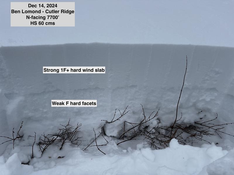
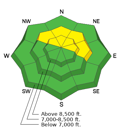
The avalanche danger is MODERATE on mid and upper-elevation slopes facing northwest through north through east, where it is possible to trigger an avalanche 1-2 feet deep, failing on a persistent weak layer of faceted snow. Recently, wind-loaded slopes at the upper elevations have been the most prone to avalanches.

Sluffing of loose wet snow should be expected with strong sunshine and warm temperatures.
Low
Moderate
Considerable
High
Extreme
Learn how to read the forecast here
Special Announcements
Now is a great time to dial in your safety gear, including putting fresh new batteries in your beacons! Local shops across the state will be handing out free Batteries for Beacons from now until February 1, 2025. All you need to do is fill out a quick survey and grab the AAA or AA batteries you need to keep your beacon fresh this season. Find participating shops and more info here.
Weather and Snow
Happy Solstice!
Under clear skies, the mountain temperatures range from 28 °F at low-elevation trailheads to 45 °F at Ben Lomond 7,700'. The wind has picked up from the southwest, blowing 15-20 mph with gusts into the 30s across the upper elevation terrain. Ogden Peak is blowing 25-30 mph gusting to 36 mph.
Today, we will see an increase in southwest wind as high pressure slides east as a storm passes overhead through Idaho and Montana. We will only see passing clouds at times. Temperatures will rise into the mid-40s and 50s °F once again. Southwest wind is forecast to blow 10-20 mph with gusts into the 20s and 30s.
We will see a small storm Sunday evening into Monday with a few inches of snow. Another storm is on tap for Christmas with what looks to be a pattern change to ring in the new year. Fingers crossed, we get some snow!
Recent Avalanches
No new avalanche activity was reported in the Ogden backcountry yesterday. Find all observations HERE.
Ad
Avalanche Problem #1
Persistent Weak Layer
Type
Location
Likelihood
Size
Description
A persistent weak layer - or PWL - of faceted snow exists on northerly-facing slopes at the mid and upper-level elevations where it is possible to trigger an avalanche up to 1-2 feet deep and over 100 feet wide. Avalanche activity and field work this week inform us that the slopes that are most prone to slide are recently wind-loaded and have a slab of stronger snow on top of the buried PWL.
I am unsure if today's increase in southwest wind will be able to drift snow onto lee slopes. Therefore, be on the lookout for new wind drifting today. Any slope loaded by the wind will be more susceptible to an avalanche.
General Announcements
This information does not apply to developed ski areas or highways where avalanche control is normally done. This forecast is from the U.S.D.A. Forest Service, which is solely responsible for its content. This forecast describes general avalanche conditions and local variations always occur.