Join us at our 2nd Annual Blizzard Ball

Forecast for the Salt Lake Area Mountains

Nikki Champion
Issued by Nikki Champion on
Monday morning, December 9, 2024
The avalanche danger is LOW. With a trace of new snowfall and multiple days of elevated wind speeds, carefully evaluate snow and terrain in areas where wind-transported snow could accumulate, potentially forming wind slabs near ridgelines that may fail on a buried layer of facets. Avoid thinner snowpack areas, where buried obstacles could lurk just beneath the surface.
Low
Moderate
Considerable
High
Extreme
Learn how to read the forecast here
Weather and Snow
This morning, skies are partly cloudy, and for the first time in about a week, there is no temperature inversion. Trailhead temperatures range from the mid-teens to low 20s, while ridgetop temperatures are in the single digits. As of 5AM there has been no measurable snowfall in some places and a trace amount in others. Winds at 9,000-foot ridgelines are blowing from the west at 20 mph, gusting up to 30 mph. At 11,000-foot ridgelines, winds are from the northwest, sustained in the mid-40s mph, with overnight gusts reaching the low 60s mph.

Today, a weak Pacific Northwest storm will bring scattered snow showers to Utah, resulting in minimal accumulations. Snow may linger into the late afternoon or evening before high pressure returns. Expect increasing clouds, with temperatures in the upper teens to low 20s. Winds at 9,000-foot ridgelines will be out of the northwest at 15 mph, gusting to 20 mph, and west-northwest at 30 mph, gusting to 35 mph, at 11,000-foot ridgelines. Snowfall totals will range from a trace to up to 3 inches by evening, with water equivalents of 0.05" to 0.20".

A weak ridge brings dry conditions and above-average temperatures Wednesday, with some valley haze likely but short-lived. A weak storm Thursday into Friday may produce light snow in northern Utah’s higher elevations and help clear the air, though moisture is limited. Another system late Saturday into Sunday could bring slightly more mountain snow, but significant precipitation remains unlikely.
Recent Avalanches
There has been no recent avalanche activity. That being said, great observations continue to trickle in.
Check out all recent observations HERE.
Ad
Avalanche Problem #1
Persistent Weak Layer
Type
Location
Likelihood
Size
Description
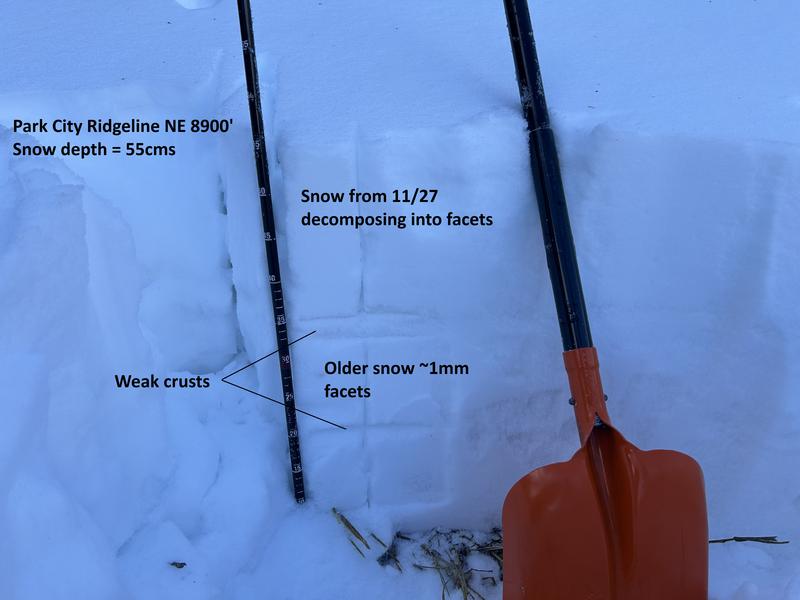
The persistent weak layer (PWL) dominating much of the snowpack on north-facing slopes continues to lose strength. As new snow or wind arrives, this weak structure will struggle to support additional weight and may begin to collapse. Take note of which slopes, aspects, and elevations are or are not holding snow, so you’ll know which areas to avoid during the next storm.
Great photo from Observer A. Paradis on the Park City Ridgeline, showing a snowpack almost entirely composed of facets and crust interfaces.

Weak snow is also forming on the surface and you can learn more about surface hoar HERE. The question is whether or not the warmer temperatures and wind will destroy this surface weakness before it snows?
Additional Information
While you're waiting for more snow, dive deeper into avalanche philosophy with Drew Hardesty HERE and HERE.
General Announcements
This information does not apply to developed ski areas or highways where avalanche control is normally done. This forecast is from the U.S.D.A. Forest Service, which is solely responsible for its content. This forecast describes general avalanche conditions and local variations always occur.