Forecast for the Moab Area Mountains

Eric Trenbeath
Issued by Eric Trenbeath on
Sunday morning, December 1, 2024
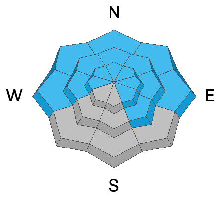
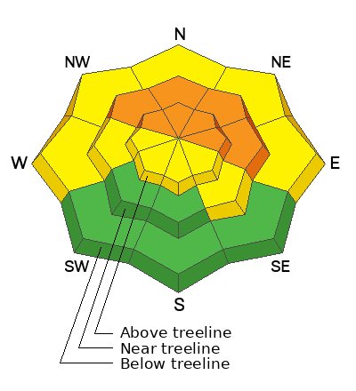
The avalanche danger remains CONSIDERABLE on steep slopes near and above treeline facing NW-N-E. In these areas, human triggered avalanches failing on a persistent weak layer of faceted snow at the base of the snowpack are likely. On slopes facing W, SE, and on low elevation northerly aspects the danger for this type of avalanche is MODERATE but the consequences are no less severe.
A MODERATE danger for triggering shallow, fresh slabs of wind drifted snow exists on all aspects in upper elevation, wind exposed terrain.
The danger is mostly LOW on slopes facing SW-S near treeline and below, and on low elevation SE aspects. Small avalanches on isolated terrain features are possible.

Conditions remain thin and rocks, stumps, and dead fall still pose a significant hazard.
Low
Moderate
Considerable
High
Extreme
Learn how to read the forecast here
Special Announcements
We have several events coming up to kick off the winter season:
Thursday, December 5 - FREE Know Before You Go avalanche awareness talk 6 PM at the Grand County Public Library
Saturday, December 7 - 17th Annual Utah Snow and Avalanche Workshop (USAW) - Information and tickets available here.
Saturday, December 14 - 3rd Annual UAC Moab/LUNA Winter Kickoff Party, 6 PM at the MARC. Information and tickets available here.
Geyser Pass Road: The Geyser Pass Road is plowed but snowpacked and slick in some areas. All wheel drive and good tires recommended. Thank you Grand County!
Weather and Snow
6 A.M. Snow and Weather Data
24 Hour Snow: 0" 72 Hour Snow: 0" Season Total Snow: 44" Depth at Gold Basin: 25"
Winds on Pre-Laurel Peak: NW 15-20 Temp: 15° F Percent of Normal (SWE): 109%
Weather
Ridge top winds from the NW have averaged around 15-20 mph for the last 24 hours but it seems to be very elevation dependent. It's been mostly calm below treeline. Today, look for sunny skies, light westerly winds, and high temps in the lower 30's. Conditions remain dry for at least a week.
General Conditions
The snowpack is showing signs of adjusting to last week's heavy load. Outward signs of instability such as cracking and collapsing are becoming less frequent, and stability tests in some areas are less reactive. In the words of Dave Garcia, the lack of obvious red flags may give one a sense of stability and "It might draw you into skiing bigger terrain and setting off a booby trap." (Read his observation here) The bottom line is that poor snowpack structure remains - a dense slab of strong snow exists over a layer of weak, sugary facets, and this is not a situation to be trusted.
Last week's dense snow has made for supportable skiing and riding and conditions are far better than they should be considering how little snow there really is. Low angle, northerly aspects remain fast and soft, and you are able to stay above many of the rocks, stumps, and dead fall. It's still low tide out there however, so use caution.
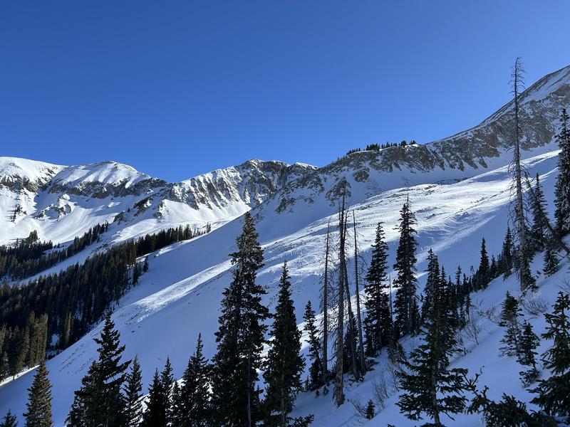
Photo below illustrates the overall good coverage we have for this time of year. Note wind loaded ripple affect center right. Suspect unstable wind slabs in areas where the surface looks like this. (Dave Garcia photo)
Snowpack and Weather Data
Gold Basin SNOTEL site (10,000')
SNOTEL site near Geyser Pass Winter Trailhead (9600')
Wind Station on Pre-Laurel Peak (11,400')
NWS forecast for the La Sal Mountains.
Ad
Avalanche Problem #1
Persistent Weak Layer
Type
Location
Likelihood
Size
Description
A dense, cohesive slab exists on top of a layer of weak, faceted snow at the base of the snowpack. This layer exists at all elevations on slopes facing W-N-E, and on SE aspects near and above treeline that still held snow prior to the storm. The danger is greatest on steep slopes near and above treeline that face NW-N-E, but human triggered avalanches are possible on all aspects where this structure is present. This problem will be with us for awhile even though signs of instability are decreasing. In fact, it now becomes even more scary as you aren't sure which slopes will slide and which won't. In some cases, a slope can be skied or ridden multiple times before it releases. Avoidance of slopes steeper than 30 degrees remains the best course of action, especially those slopes that have a northerly aspect.
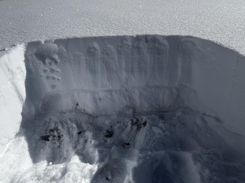
Photos below illustrates the structure of a strong, dense slab over weak, faceted snow.
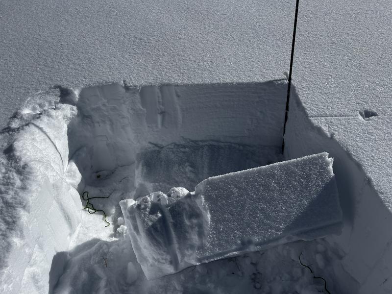
Photo below illustrates the results of an extended column test performed on a west aspect at 10,300' on November 27. (ECTP 11)
Avalanche Problem #2
Wind Drifted Snow
Type
Location
Likelihood
Size
Description
Remain on the lookout for shallow, fresh slabs of wind drifted snow on the leeward sides of ridge crests and terrain features in exposed terrain. Fresh drifts often have a smooth, rounded, or rippled appearance. They also may sound or feel hollow underneath. Cracking is a sign of instabilty.
Additional Information
Sign up for text alerts to get the most up to date information about changing conditions, road plowing, special avalanche announcements.
Follow us on Instagram @utavy_moab
General Announcements
This forecast is from the U.S.D.A. Forest Service, which is solely responsible for its content. This forecast describes general avalanche conditions and local variations always occur.