Check out our Holiday Auction

Forecast for the Provo Area Mountains

Dave Kelly
Issued by Dave Kelly on
Saturday morning, November 30, 2024
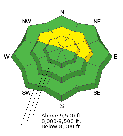
The avalanche danger is MODERATE on slopes facing northwest through north and east at the mid and upper elevations where it may be possible to trigger an avalanche up to 2' deep and 80' wide failing on a persistent weak layer of faceted snow near the ground. The avalanche danger is LOW on all other aspects and elevations.
As our snowpack adjusts to the most recent snow; the in-your-face nature of this problem such as cracking, collapsing, and recent avalanches will be harder to see. Carefully assess where these buried facets may be before ascending or descending a slope greater than 30° in steepness.
Low
Moderate
Considerable
High
Extreme
Learn how to read the forecast here
Special Announcements
The 17th Annual Utah Snow and Avalanche Workshop (USAW) is scheduled for Saturday December 7th - Information and tickets available here.
If you trigger or see an avalanche adjacent to the road or one of the ski areas and are sure no one was caught in the avalanche, call the nearest mountain dispatch and alert them to the situation, this will allow SAR teams to stand down, preventing them from being subjected to unnecessary hazard.
  • Sundance Dispatch- (801-223-4150)
Quick refresher on Backcountry Emergencies and Avalanche Response HERE. You may just save a life
Weather and Snow
Under clear skies mountain temperatures are in the teens to low 20's°F. Some localized stations like Aspen Grove are in the low teens °F. Winds are blowing primarily from the west- southwest in the single digits at the 8,000' ridgelines and from the west in the high teen's gusting to the 20's MPH at the highest ridgelines. Down canyon winds are blowing in the 20's MPH and should switch directions and blow upcanyon later this afternoon
The snow surface is a mixed bag. You'll find melt freeze crust on the southerly aspects in the morning that will warm up in the afternoon sun. The surface on the north facing slopes is starting to facet and there are still wildflowers and rocks poking through on all aspects.
Today, skies will be mostly clear with high clouds in the early afternoon. Temperatures will be 19-24°F and winds will blow from a westerly direction 5 gusting to 10 at the 9,000 ridgelines and from the west 25 gusting to 30 MPH at the 11,000 ridgelines. The freezing level will be at valley level and slowly rising over the next few days as an inversion sets in. The forecast looks good for continued facet growth on northerly facing aspects over the next week.
Recent Avalanches
The last reports of avalanches in the Provo Area mountains are from Tuesday November 26th. Check out Woody's avalanche observations HERE.

Just north of the Provo Area Mountains we've had reports of rider triggered avalanches failing on facets on north facing slopes. This is similar to what you may find in the high elevation north-east terrain in the Provo Area. The below video shows propagation on the Two Dogs Avalanche (north facing slope 10,260').
Video: (Sam K)
Ad
Avalanche Problem #1
Persistent Weak Layer
Type
Location
Likelihood
Size
Description
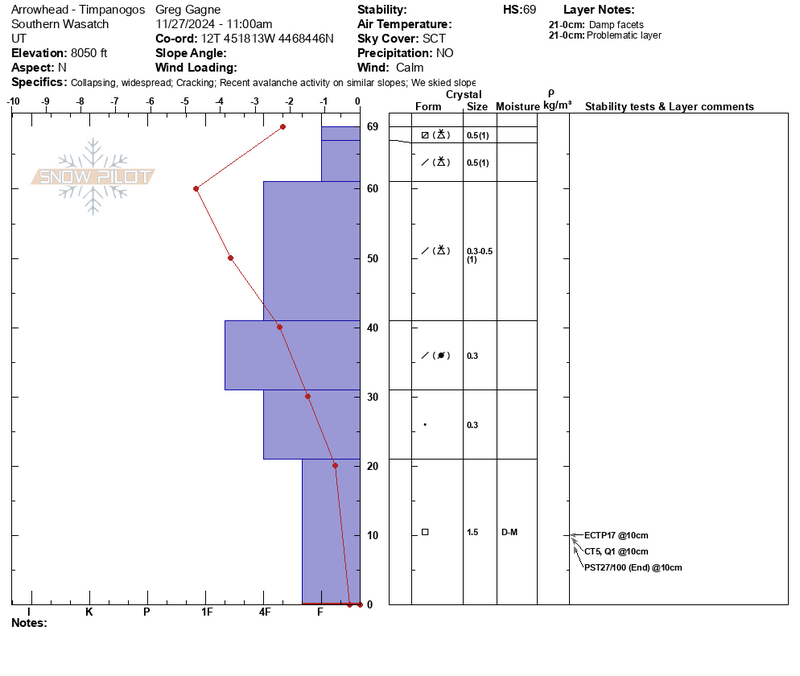
If you choose to venture onto slopes where this persistent weak layer (PWL) may exist, dig down and look for the structure of strong (harder/firmer) snow on top of weak (softer/looser) snow. If you see this structure, it is may be possible to trigger an avalanche up to 2' deep and over 80' wide. This problem has been most notable on aspects facing north-east but we can't take it off other aspects until we have more information.

Snowpilot profile from Greg's recent field day in Provo with Woody from UDOT. This profile shows strong snow over weak snow near the ground.
General Announcements
This information does not apply to developed ski areas or highways where avalanche control is normally done. This forecast is from the U.S.D.A. Forest Service, which is solely responsible for its content. This forecast describes general avalanche conditions and local variations always occur.