Check out our Holiday Auction - Sign Up for the Utah Snow and Avalanche Workshop (USAW)

Forecast for the Moab Area Mountains

Dave Garcia
Issued by Dave Garcia on
Wednesday morning, February 7, 2024
Very strong Southerly winds and heavy snowfall have caused the avalanche danger to rise to HIGH in the La Sal Mountains. Deep and dangerous natural avalanches failing on a buried persistent weak layer are LIKELY. Human-triggered avalanches are VERY LIKELY. The danger is most prominent on slopes near treeline and above that face W-NW-N-NE-E-SE. On all other slopes, the danger is CONSIDERABLE and humans are LIKELY to trigger avalanches within the new snow and in fresh slabs of wind-drifted snow.
These are very dangerous avalanche conditions. Travel in avalanche terrain is not recommended.
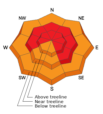
Low
Moderate
Considerable
High
Extreme
Learn how to read the forecast here
Special Announcements
Road Conditions: The Geyser Pass Road will be very challenging this morning with up to a foot of new snow (mostly up high) and very strong winds. Expect to encounter deep drifts on the upper section of the road.
Grooming: Trails will be snow covered today.
Weather and Snow
6:00 a.m. Snow and Weather Data
24 Hour Snow 12" 72 Hour Snow 12" Season Total Snow 119" Depth at Gold Basin 47"
Winds on Pre-Laurel Peak: SSE 35 G44 Temp 27 Percent of Normal: 105%

Weather
Skies are overcast and it is currently snowing. The atmospheric river event will continue today. Snowfall could be heavy at times. A foot of new snow has fallen overnight and we should see another 6-12" of accumulation today. Southerly winds overnight blew in the 40's MPH with gusts into the mid 50's MPH. Strong Southerly winds will continue to blow throughout the day at 25-30 MPH with gusts around 40 MPH. Some thunder is possible due to convective activity. Snowfall rates will decrease overnight into Thursday, but another shortwave trough comes in from the desert Southwest Thursday night. Snowfall will continue, through Saturday. Totals for Friday and Saturday don't look as impressive as today's event, but we will see accumulating snow each day until things finally calm down Saturday night.
General Conditions
Today will be full-on storm skiing with heavy snow and strong winds. The avalanche danger is HIGH, and backcountry travelers should avoid all avalanche terrain. Trail breaking will be deep and difficult. There is already a foot of new snow. The combination of continued heavy snowfall and very strong winds will produce a natural avalanche cycle. The buried persistent weak layer (PWL) will be overloaded by accumulating and wind-drifted snow. Deep and dangerous avalanches will occur naturally on a variety of aspects. Human-triggered avalanches are very likely. In addition to the destructive avalanches failing on the PWL, humans are likely to trigger avalanches on fresh slabs of wind-drifted snow on all aspects. Finally, dry-loose and soft slab avalanches will be possible within the new snow. If this sounds complicated, that's because it is. However, the travel advice remains very simple, travel in avalanche terrain is not recommended.
Snowpack and Weather Data
Gold Basin Storm Stake (10,000')
Gold Basin SNOTEL site (10,000')
SNOTEL site near Geyser Pass Winter Trailhead (9600')
Wind Station on Pre-Laurel Peak (11,400')
NWS forecast for the La Sal Mountains.
Recent Avalanches
Last Saturday we saw a widespread natural avalanche cycle. These were deep and dangerous avalanches failing on the buried persistent weak layer of faceted snow. Natural avalanches occurred on slopes facing W-NW-N-NE. More avalanches like these will happen today. On Sunday, there was a very large (R3, D3) human-triggered avalanche on the NE face of Mt. Tukno. The weekend's avalanche activity is a good indicator of what will happen today with rapid loading. The La Sal avalanche data base has been recently updated and you can check out all of the recent avalanches here.
Ad
Avalanche Problem #1
Persistent Weak Layer
Type
Location
Likelihood
Size
Description
All of the new snow is falling on a weak snowpack. The persistent weak layer (PWL) is now buried more than 3 feet below the surface. The widespread avalanche activity over the weekend shows the PWL remains very sensitive. Heavy accumulations and blowing and drifting snow from very strong winds will easily overload this layer and produce another natural avalanche cycle. Slopes that don't avalanche on their own will be left teetering on the brink of collapse, and humans are very likely to trigger avalanches on any steep slope. If you are venturing into the mountains today the strategy is simple, avoid all avalanche terrain.
Avalanche Problem #2
Wind Drifted Snow
Type
Location
Likelihood
Size
Description
Southerly winds overnight reached the extreme range and gusted into the mid-50's MPH. These winds have been sustained since Monday. Backcountry travelers will encounter both soft and hard slabs of wind-drifted snow in the mountains today. These slabs will be most prominent near treeline and above, but we have seen strong winds at very low elevations and wind-drifted snow will penetrate into the below treeline zone as well. You can expect hard, stiff slabs to form further down a slope then you might expect. This is a dangerous situation, because it allows you to get further out on the slab before it breaks above you.
These winds will continue to blow and drift snow and overload the buried PWL. Any avalanche triggered in a wind slab has the ability to step down to the PWL causing a very deep and dangerous avalanche. Travel advice remains the same, avoid all avalanche terrain.
Avalanche Problem #3
New Snow
Type
Location
Likelihood
Size
Description
There is a foot of new snow, and moderate to heavy snowfall will continue throughout the day. Dry-loose avalanches and storm slab avalanches will be possible. The type of avalanche will depend on how well the new snow bonds compared to the rate of snowfall. Small test slopes are a great way to look for signs of instability, like cracking and sluffing in the new snow. High precipitation intensity (2 inches per hour) will make avalanches easy to trigger.
If you are up skiing today, it is a good day to be mindful of what is around you in the terrain. Avoid gullies and terrain traps where new snow avalanches can pile up quickly.
Additional Information
Want some more insight into the La Sal Mountains as well as the communal impacts of a tragic avalanche? Check out the latest UAC podcast with forecaster Eric Trenbeath where he discusses the range, it's often treacherous snowpack, and how the devastating avalanche in February, 1992, affected the Moab community.
Our avalanche beacon checker sign and beacon training park are up and running. A huge thanks to Talking Mountain Yurts for sponsoring those this season!
Sign up for forecast region-specific text message alerts. You will receive messages about changing avalanche conditions, watches, warnings and road plowing closures.
Follow us on Instagram @utavy_moab
General Announcements
This forecast is from the U.S.D.A. Forest Service, which is solely responsible for its content. This forecast describes general avalanche conditions and local variations always occur.