Check out our Holiday Auction - Sign Up for the Utah Snow and Avalanche Workshop (USAW)

Forecast for the Moab Area Mountains

Eric Trenbeath
Issued by Eric Trenbeath on
Saturday morning, April 15, 2023
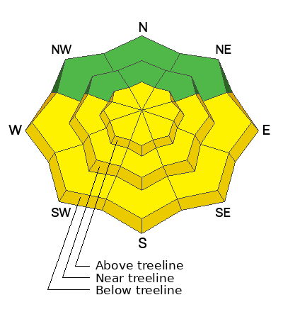
A MODERATE danger exists for human triggered avalanches involving fresh slabs of wind drifted snow on steep slopes facing N-E-S above treeline. Shallow sluffs may also occur in very steep terrain on all aspects.

A MODERATE danger also exists for loose, wet sluffs on sun exposed slopes. Avoid steep slopes when they become wet and sloppy.

Cornices are massive, give them a wide berth.
Low
Moderate
Considerable
High
Extreme
Learn how to read the forecast here
Special Announcements
Sunday will be our last regularly scheduled daily forecast.
Geyser Pass Road: A few inches of snow will quickly melt off today creating muddy conditions.
Grooming: Gavin pulled an all-nighter last night and all trails are groomed for the weekend!
Weather and Snow
6:00 a.m. Snow and Weather Data
24 Hour Snow 3" 72 Hour Snow 7" Season Total Snow 322" Base Depth at Gold Basin 96"
Temp 14°F Winds on Pre-Laurel Peak: NW 25-30 G 40

Weather
Sunny skies are on tap through the weekend as a transient ridge builds over the region. High temps today will climb into the mid 30's, and up into the mid 40's on Sunday. The only fly in today's ointment is the pesky NW winds. They started ramping up yesterday evening, averaging 25-30 mph for the last six hours along ridge tops. They should back off some as the day gets going. After Sunday's peak warm up, cooler temperatures and an unsettled pattern return for next week.
General Conditions
6"-8" of new snow since Thursday night should make for some pretty good conditions today in areas that haven't been affected by the NW winds. Hopefully they haven't damaged things too much. On the flip side, fresh slabs of drifted snow exist on slopes facing north through east through south above treeline. The new snow may not bond well to the underlying crust, and the slick surface may allow slabs to break wider than expected. Suspect slopes that have about 8" or more of drifted snow. The new snow will be at it's most vulnerable when the sun hits it today, and we could see some small, direct action, loose wet sluffs on sun exposed slopes. These shouldn't be too problematic, but it's good policy to avoid steep slopes that have been too long under the sun this time of year.
Snowpack and Weather Data
Gold Basin Storm Stake (10,000')
Gold Basin SNOTEL site (10,000')
SNOTEL site near Geyser Pass Winter Trailhead (9600')
Wind Station on Pre-Laurel Peak (11,400')
NWS forecast for the La Sal Mountains.
Recent Avalanches
Ad
Avalanche Problem #1
Wind Drifted Snow
Type
Location
Likelihood
Size
Description
Be on the lookout for fresh deposits of wind drifted snow on steep slopes above treeline that face primarily north through east through south. Drifts are recognizable buy their smooth, rounded appearance, and cracking is a sign of instability. Even a small triggered wind slab could carry you over a cliff, or take you for a long ride in areas of more extreme terrain.
Avalanche Problem #2
Wet Snow
Type
Location
Likelihood
Size
Description
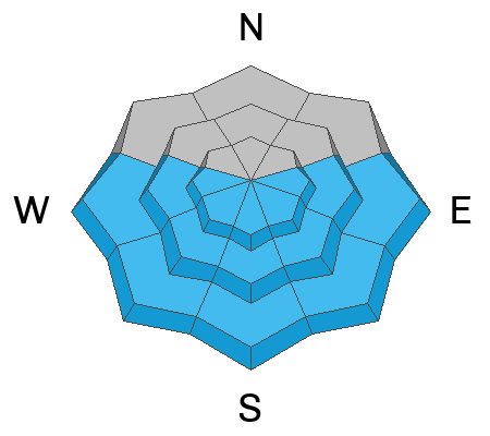
As the day heats up the new snow will be in it's most vulnerable state and we could see some small, direct action, loose wet sluffs. Rollerballs and pinwheels are signs of increasing instability. Avoid steep slopes when they get wet and sloppy.
General Announcements
This forecast is from the U.S.D.A. Forest Service, which is solely responsible for its content. This forecast describes general avalanche conditions and local variations always occur. This forecast will be updated by 7:30 tomorrow morning.