Forecast for the Skyline Area Mountains

Brett Kobernik
Issued by Brett Kobernik on
Friday morning, January 13, 2023
The overall danger rating is MODERATE today.
Human triggered avalanches are possible especially on upper elevation north through east facing slopes.
That said, the new snow has had 48 hours to settle and stabilize and the chances for triggering anything are becoming less.
Low
Moderate
Considerable
High
Extreme
Learn how to read the forecast here
Special Announcements
State Road 31 is still closed from the top of Fairview Canyon through Huntington Canyon for snow removal today. The closure is at the intersection of State Road 264 through mile marker 33 in Huntington Canyon. The north Skyline Drive trailhead is accessible as well as State Road 264. Photo below: Crews clearing snow from an avalanche that buried the road.
Weather and Snow
Current Conditions: Thursday was a beautiful day in the mountains with plenty of fresh powder and sun. Temperatures got into the low to mid 30s and many sunny facing slopes became damp. You'll find melt/freeze crusts on them this morning. The wind speeds were light and remain pretty light this morning from the southwest.
Mountain Weather: It looks like another nice day out there again today with temperatures again into the low to mid 30s. We might not see quite as much sun as high clouds will be streaming through. Wind will be from the southwest and will gradually increase in speed through the day. More clouds move in on Saturday ahead of the next storm. We could see some light snowfall Saturday afternoon. Most of the snow will be Saturday night through mid day Sunday. Rough estimates as of this morning look like 6 to 12 inches by late Sunday. More storms are shaping up for next week.
Recent Avalanches
Explosive control work on Thursday in Huntington Canyon pulled out the remaining slabs adjacent to a natural avalanche that blocked the road early Wednesday morning. These avalanches broke 4 feet deep down to the ground. Crews are now working to clear the debris. NOTE: These avalanches are in unique terrain on very steep man made road cuts and are not very representative of average conditions on the Skyline right now.
Ad
Avalanche Problem #1
Normal Caution
Type
Location
Likelihood
Size
Description
The snowpack is really settling and stabilizing nicely. There was natural avalanche activity within the new snow from the last storm. This new snow seems to have stabilized and does not appear very sensitive to people after a couple of days of settling. As far as I know, there were no significant avalanches that broke into the old November Persistent Weak Layer during or after the last storm. This is good news. (TAP/CLICK FOR FULL UPDATED DETAILS OF THE NOVEMBER WEAK LAYER PROGRESSION)
Personally, I'm willing to start stepping out cautiously into some selective steeper terrain. A lot has happened in a short amount of time so I'm holding my cards fairly tight still. However, all indicators are pointing to better stability.
If you are thinking about getting into steeper terrain, here are some thoughts:
  • Only expose one person at a time to steep slopes.
  • Make sure your party is not grouped up at the bottom of steep slopes.
  • Make sure everyone is equipped with the proper avalanche gear and knows how to use it.
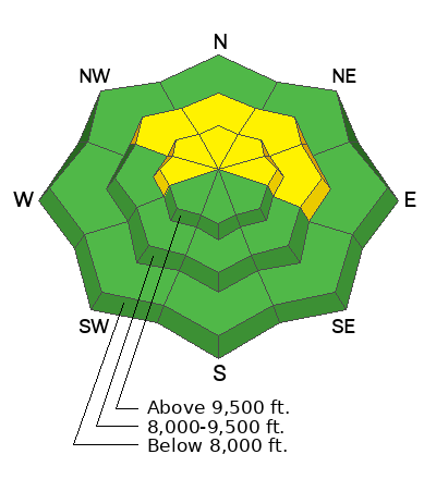
  • The most likely places to find trouble are going to be on the more radical steep upper elevation terrain that faces northwest, north, northeast and east.
  • Don't monkey around with cornices. They are large, pretty fresh and are likely to break off if provoked.
General Announcements
This forecast is from the U.S.D.A. Forest Service, which is solely responsible for its content. This forecast describes general avalanche conditions and local variations always occur.