Check out our Holiday Auction - Sign Up for the Utah Snow and Avalanche Workshop (USAW)

Forecast for the Moab Area Mountains

Eric Trenbeath
Issued by Eric Trenbeath on
Monday morning, January 2, 2023
DANGEROUS AVALANCHE CONDITIONS
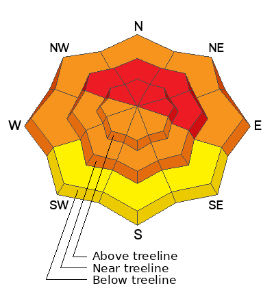
The avalanche danger is HIGH today on all steep, wind drifted slopes near and above treeline that face NW-N-NE-E. Avoid being on or under steep slopes in these areas where natural and human triggered avalanches up to 4' deep are likely. A CONSIDERABLE avalanche danger exists on W-SW-S-SE aspects near treeline and above, and on steep northerly facing slopes below. In these areas, human triggered slab avalanches involving new and wind drifted snow could step down into buried persistent weak layers producing deeper, and more dangerous avalanches. Avalanche terrain should be avoided today. Stay off of and out from under slopes steeper than 30 degrees and avoid avalanche run out zones.
Low
Moderate
Considerable
High
Extreme
Learn how to read the forecast here
Avalanche Warning
* WHAT...The avalanche danger is HIGH across northern, central, southeast, and southwest Utah.
* WHERE...For most mountains in Utah and southeast Idaho, including the Wasatch Range, Bear River Range, Uinta Range, Manti-Skyline, Fish Lake Region, La Sal and Abajo Mountains of Southeastern Utah, Pavant Range, Tushar Range, and Cedar City area mountains.
* WHEN...In effect from 6AM MST this morning to 6AM MST Tuesday
* IMPACTS...Very dangerous avalanche conditions exist. Natural and human triggered avalanches are likely on many slopes and may be triggered at a distance. Stay off of and out from under slopes steeper than 30 degrees.
Special Announcements
Road Conditions: Snow is accumulating on the road since the last plow and the top is rutted and soft. 4x4 with good tires recommended.
Grooming: LUNA groomed all trails on Friday. 16" of snow has fallen since.
Weather and Snow
24 Hour Snow 7" 72 Hour Snow 16" Season Total Snow 115" Base Depth at Gold Basin 59"
Winds on Pre Laurel Peak SSE 20 G30 Temp 24F
Weather
A potent storm system is tracking through the Four Corners this morning bringing more snow and wind to the mountains. After a day of strong southerly winds yesterday with gusts to 57 mph, it started snowing again around 10:00 pm last night. Southerly winds remained constant in the 20-30 mph range. Snowfall should continue today and linger into tonight with another 5"-9" possible. The storm moves on by tomorrow though we'll continue to see cloudy skies and a chance for snow. We'll see a break on Wednesday with the next chance for snow developing by Thursday.

General Conditions
It's been a wild start to the New Year with conditions this weekend. Since Friday we've seen 16" of snow, developed a rime crust up to at least 11,000', and endured southerly winds over 50 mph. Cummulative snowfall since things picked up last Tuesday is now over 3' at 4.5" of Snow Water Equivalent. Several large natural avalanches averaging 4' deep occured on Wednesday, and a reactive persistent weak layer was observed on all aspects. Slopes that have not avalanched are teetering on the brink as more snow is incrementally added and slopes steeper than 30 degrees should be avoided. The balance is most tenuous on steep, northerly aspects where dense, wind drifted snow has built thick slabs over the persistent weak layer. In these areas, avalanche terrain should be given a wide berth by staying clear of run out zones.

Snowpack and Weather Data
Gold Basin Storm Stake (10,000')
Gold Basin SNOTEL site (10,000')
SNOTEL site near Geyser Pass Winter Trailhead (9600')
Wind Station on Pre-Laurel Peak (11,400')
NWS forecast for the La Sal Mountains.
Recent Avalanches
Here is a list of avalanches from last Wednesday's natural cycle. No recent avalanches have been reported.
Ad
Avalanche Problem #1
Persistent Weak Layer
Type
Location
Likelihood
Size
Description
A persistent weak layer (PWL) of faceted snow that developed during the cold dry period in mid November exists on all aspects and elevation bands in the La Sal range. Dangerous avalanche conditions exist on any slope that harbors this buried PWL including those facing south. On northerly aspects, new and wind drifted snow has added more stress to this buried weak layer, and human triggered avalanches up to 4' deep or more are likely. The snowpack is undergoing a severe test right now. Once this round of snow is finished, we'll have a better idea about the future of our snowpack. For now, all slopes steeper than 30 degrees should be avoided.
Avalanche Problem #2
Wind Drifted Snow
Type
Location
Likelihood
Size
Description
Blowing and drifting snow has created unstable slabs a foot or more deep on leeward slopes facing W-N-E near and above treeline. Dangerous in and of themselves, triggered wind slabs on these aspects are likely to produce much deeper and more dangerous avalanches failing on a buried persistent weak layer. Avoid all steep, wind drifted slopes.
Avalanche Problem #3
New Snow
Type
Location
Likelihood
Size
Description
Dense, inverted slabs have been developing in the snow that has fallen since Friday. As new snow continues to accumulate, the likelihood for human triggered, soft slab avalanches will increase on all aspects. Any avalanche triggered within the new snow has the potential to step down into a buried, persistent weak layer causing a deeper, more dangerous avalanche. Travel advice remains the same, avoid avalanche terrain.
Additional Information
General Announcements
This forecast is from the U.S.D.A. Forest Service, which is solely responsible for its content. This forecast describes general avalanche conditions and local variations always occur. This forecast will be updated by 7:30 tomorrow morning.