Forecast for the Skyline Area Mountains

Brett Kobernik
Issued by Brett Kobernik on
Saturday morning, December 31, 2022
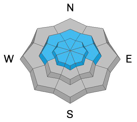
The overall avalanche danger is rated HIGH today.
Human triggered and natural avalanches are likely today.
Avoid all avalanche terrain which means staying off of and out from underneath slopes steeper than 30 degrees.
Avalanches can be triggered from a distance right now so it is important to not be underneath steep slopes where an avalanche can hit you from above.
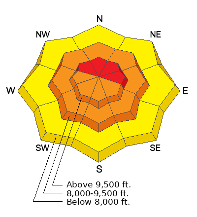
Low
Moderate
Considerable
High
Extreme
Learn how to read the forecast here
Avalanche Warning
What: The avalanche danger is expected to be HIGH.
When: In effect from 6 am MST Saturday morning to 6 am MST Monday
Where: For the mountains of northern and central Utah, including southeast Idaho. This includes the Wasatch Range, the Bear River Range, the Western Uintas, and the Manti-Skyline Plateau.
Impacts: Very dangerous avalanche conditions exist. With heavy snowfall and strong winds, both human-triggered and natural avalanches are likely. Stay off of and out from under slopes steeper than 30 degrees.
Weather and Snow
Current Conditions: The northern end of the Skyline picked up another 7 inches of snow in the last 24 hours. The southern end has only received a few inches. Temperatures are warm and the snow is dense. Most stations are right about 30˚F this morning. The rain/snow line is probably in the 8000' range. Wind has been from the southwest with moderate to strong speeds along the ridges.
Mountain Weather: We should see periods of snow continue this morning with perhaps a lull this afternoon then more snow tonight and through Sunday. Weather models insist on 1 to 2 inches of water so this should translate to another foot of snow or better by Monday. Temperatures will stay quite warm today and tonight then start cooling on Sunday. Wind will be from the southwest with moderate to strong speeds today, slowing on Sunday.
Ad
Avalanche Problem #1
Persistent Weak Layer
Type
Location
Likelihood
Size
Description
The buried Persistent Weak Layer of sugary faceted snow from November is active after the addition of Wednesday's foot of fresh snow. There have been reports of snowmobile triggered avalanches as well as people experiencing collapsing (whumpfing) of the snowpack. We'll see additional snow today through Sunday. The wind is going to continue to drift snow and load slopes. This is not the time to be in avalanche terrain.
General Announcements
This forecast is from the U.S.D.A. Forest Service, which is solely responsible for its content. This forecast describes general avalanche conditions and local variations always occur.