Forecast for the Skyline Area Mountains

Brett Kobernik
Issued by Brett Kobernik on
Wednesday morning, December 28, 2022
ANTICIPATE ELEVATED AVALANCHE DANGER THROUGH THE WEEK.
The avalanche danger is rated at CONSIDERABLE today.
Human triggered avalanches 1 to 3 feet deep are likely.
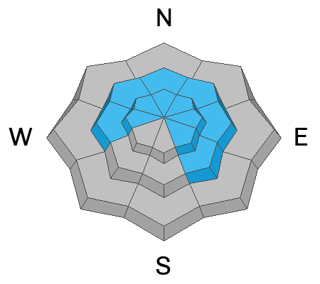
The most likely places to trigger an avalanche are on mid and upper elevation slopes steeper than 30˚ that face west through north through southeast.
Upper elevation steep slopes that face north through east are especially dangerous.
Low
Moderate
Considerable
High
Extreme
Learn how to read the forecast here
Weather and Snow
Current Conditions: Around a foot of new snow accumulated over the last 24 hours. It looks like the northern half of the Skyline did slightly better than the southern end. It's still snowing as of 7:00am and the snow level finally dropped to the valley recently. Ridgetop wind has been from the southwest and has been in the moderate speed category with some stronger gusts. It's been strong enough to drift snow in the higher terrain. Temperatures started out very warm with this storm. It rained up to around 8000', and briefly to 8500'. Temperatures have been gradually cooling and are in the mid 20s this morning.
Mountain Weather: We should see periods of snow today and tonight with a few more inches of accumulation possible. Wind will shift and blow from the northwest with moderate speeds. Temperatures will gradually cool later on today. We have a break in the action for Thursday and a more significant storm still on track for Friday and into the weekend.
Ad
Avalanche Problem #1
Persistent Weak Layer
Type
Location
Likelihood
Size
Description
The biggest avalanche threat today is an avalanche that breaks into the Persistent Weak Layer of faceted snow that formed in mid November. (click/tap here for updated details on this weak layer) I am unsure of just how sensitive the weak layer will be after this storm's additional load. The good news is that the weak layer has gained some strength recently and the new snow isn't all that big of a new load. The bad news is you can never trust a buried layer of sugary faceted snow until it is proven to be completely stable. I wouldn't screw around with steep slopes today. My strategy is to let the storms this week take their course and then reevaluate the stability of this weak layer after things have settled. My hope is that as these storms add more snow, we don't see any natural avalanches and don't experience cracking or collapsing. If we don't see any of that stuff, I'll feel pretty good that the weak layer has stabilized to the point of being safe. Until then, all bets are off.
General Announcements
This forecast is from the U.S.D.A. Forest Service, which is solely responsible for its content. This forecast describes general avalanche conditions and local variations always occur.