Check out our Holiday Auction

Forecast for the Logan Area Mountains

Toby Weed
Issued by Toby Weed on
Monday morning, December 26, 2022
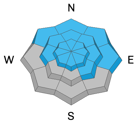
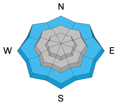
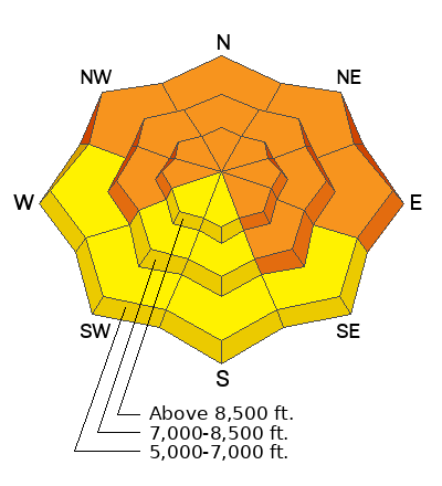
Heightened avalanche conditions exist on most slopes at all elevations, and areas with CONSIDERABLE danger remain on slopes with buried persistent weak layers and poor snow structure. Dangerous avalanches 1 to 4 feet deep could still be triggered remotely, from a distance or below. Above freezing temperatures and light rain at lower and mid elevations elevated the danger of wet avalanches on slopes with saturated surface snow.

People can safely venture into the backcountry by staying off of and out from under slopes steeper than 30°. Continue to evaluate snow and terrain carefully.
*PLAN ON VERY DANGEROUS AVALANCHE CONDITIONS DEVELOPING TUESDAY AS A WET AND WARM PACIFIC STORM IMPACTS THE REGION*
Low
Moderate
Considerable
High
Extreme
Learn how to read the forecast here
Special Announcements
As the end of the year approaches, please consider a donation to the UAC to support avalanche forecasting.
Didn’t get what you want for Christmas? Do your loved ones simply give you money for the holidays and say “Go buy something for yourself?” Support the UAC and get a great gift for yourself or your loved one at our Holiday Auction. The auction closes at 8:00 PM MT on January 2, 2023.
Weather and Snow
Last week's winds and snowfall created widespread slabs of wind drifted snow that overloaded a buried persistent weak layer buried 1 to 4 feet deep. The crazy winds and a bit of freezing rain in the past couple days have done a number on snow surface conditions, and there's not really much in the way of nice powder to be found these days. The good news is that a prolonged winter storm is headed our way this week, and we could get lots of snow in the mountains. Looks like very dangerous avalanche conditions and HIGH danger will likely develop on many backcountry slopes in the next couple days.
There is a misty rain/snow mix visible on Beaver's Webcams this morning, with less than an inch of accumulation overnight. It's 33° F at the 8400' Tony Grove Snotel where there is 49 inches of total snow. On Logan Peak winds are blowing from the west 15 to 25 mph.
  • It'll be mostly cloudy in the mountains today, with 8500' high temperatures around 34° F and 10 to 15 mph southwest winds.
  • Tonight will be partly cloudy, but with increasing winds from the southwest, cloudiness, and temperatures. Temperatures will top out around 31° F at 8500' with winds gusting around 40 mph.
  • Snow will fall in the mountains tomorrow, heavily at times. Expect 8500' temperatures around 32° F, and fairly strong winds blowing 25 to 30 mph and gusting well into the 40s from the southwest. 6 to 10 inches of accumulation is possible at upper elevations by evening.
  • Snowfall, heavy at times, will continue tomorrow night with another 9 to 13 inches possible by early Wednesday morning. Temperatures will drop to around 17° F, and winds will blow from the west-southwest 15-20 mph, with gusts around 35 mph.
We should see thing let up a bit on Wednesday and Thursday, but snow will continue to fall and accumulate in the mountains through the week and perhaps on into the new year...
Recent Avalanches
Avalanche activity spiked during last week's snow and wind, but there have been no avalanches reported since then. See our updated list of observed avalanches from the Logan Zone HERE and from across Utah HERE
Ad
Avalanche Problem #1
Persistent Weak Layer
Type
Location
Likelihood
Size
Description
Persistent weak layers formed in November continue to plague many slopes, and last week's windy storm created a thick slab overlaying the weak layers, which created poor snow structure and an unstable snow situation in many areas.
There's a good chance a person can trigger a slab avalanche on a buried persistent weak layer of facets 1-4 feet deep. Where the snow is deepest like at upper elevations, this layer may be starting to gain some strength, but in areas with shallower snow, like low elevations or places scoured by winds, this widespread layer of loose sugary snow remains weak.
Mark rode throughout Copenhagen Basin Friday and found an unstable layer of surface hoar on top of these facets (video below). He thought he would have easily triggered a slide if he had tried to ride on a steep slope. The party experienced plenty of collapsing.
***Since we don't trust slopes with this kind of buried persistent weak layer, we'll continue to avoid avalanche terrain where it exists by staying off and out from under slopes steeper than 30°.
Avalanche Problem #2
Wet Snow
Type
Location
Likelihood
Size
Description
Above freezing temperatures and a bit of rain are saturating the snow surface and causing elevated wet avalanche conditions on lower and perhaps mid elevation slopes.
Avoid being on or under steep slopes with saturated snow. Roller balls, pinwheels, and moist surface sluffs all indicate potential for wet avalanche activity.
Additional Information

Take the all-new online avalanche courses the UAC built for Know Before You Go or take other online courses listed on the KBYG website (Develop skills -> Online Learning).
Remember, when you leave the ski area boundary, Beaver Mt or Cherry Peak, you are entering the backcountry, and you could trigger dangerous avalanches....
  • Put fresh batteries in your transceiver and inspect your shovel and probe.
  • Practice Companion Rescue with your backcountry partners.
General Announcements
As the end of the year approaches, please consider a donation to the UAC to support avalanche forecasting.
Please submit your observations from the backcountry HERE.
For a list of avalanche classes from the Utah Avalanche Center go HERE
For information on where you can ride your sled or snowbike, check out this map of the winter travel plan for the Tony Grove and Franklin Basin Areas HERE.
This forecast is from the U.S.D.A. Forest Service, which is solely responsible for its content. This forecast describes general avalanche conditions and local variations always occur.