Check out our Holiday Auction

Forecast for the Logan Area Mountains

Nikki Champion
Issued by Nikki Champion on
Sunday morning, December 11, 2022
High winds and heavy snowfall will cause the avalanche danger to rise to CONSIDERABLE throughout the day. Pay attention to changing weather - avalanche danger will increase as this storm intensifies.
Today, there are two primary avalanche problems to watch for: (1) triggering a slab avalanche 1-3' deep in the weak faceted snow, and (2) both soft and hard slabs of wind-drifted snow that would likely steep down into the weak snow below.

You'll find nice powder and much safer conditions in lower-angle terrain, sheltered slopes, and at lower elevations.
Low
Moderate
Considerable
High
Extreme
Learn how to read the forecast here
Special Avalanche Bulletin
STRONG SOUTHERLY WINDS, COUPLED WITH DENSE, HEAVY SNOW WILL MAKE THE AVALANCHE DANGER RISE OVER THE NEXT 24 HRS, POTENTIALLY REACHING HIGH AVALANCHE DANGER BY THIS EVENING. LARGE, DANGEROUS AVALANCHES BECOME MORE LIKELY AS THE STORM MATERIALIZES. AVOID BEING ON, UNDER, OR ADJACENT TO STEEP WIND-DRIFTED SLOPES AND TERRAIN STEEPER THAN 30 DEGREES.
Special Announcements
Thanks for showing up Tuesday night and supporting the UAC. It was great to see everybody at the Cache! You made our annual Pray for Snow party/fundraiser a big success.

Join the Utah Avalanche Center and the Division of Outdoor Recreation to celebrate the Fourth Annual Avalanche Awareness week, from December 4 - December 11. Click HERE to view the full list of events for the week.
Weather and Snow
Last week's heavy snow and drifting overloaded many slopes plagued by buried weak layers and poor snow structure. Dangerous human-triggered avalanches remain possible for people to trigger, especially on previously drifted upper and mid-elevation slopes. With the new snow, and elevated winds on the horizon fresh drifts could be very sensitive and we can expect to see people triggering avalanches today at both mid and upper elevations. It's possible that a small avalanche overrunning a slope with poor snow structure could step down into sugary November snow and create a much larger hard-slab avalanche.
Although much less frequently in the last few days, observers continue to report localized audible collapses or "wumpfs" from across the zone. Collapsing indicates unstable snow and real potential for dangerous slab avalanches failing on a buried persistent weak layer.

The National Weather Service has issued a Winter Storm Warning that will go into effect this morning at 11:00 am lasting through Tuesday at 5:00 pm. A significant winter storm will impact the area through at least Tuesday, with the potential for lingering snow into Wednesday. Strong south-to-southwesterly winds will continue through the day today and into tonight, with gusts well above 50 mph. Snow will develop this afternoon, becoming heavy near 3-6 PM tonight. Total snow accumulations of 12 to 24 inches. Temperatures will remain in the mid-30s F throughout the day, before plummeting into the mid-teens F overnight.
Snowfall may decrease in intensity late Monday morning into Monday afternoon, and redevelop later Monday afternoon into Monday evening with additional accumulation.
With this storm, avalanche conditions will rapidly be on the rise. Snowfall rates may exceed 2 inches per hour at times, which will greatly increase the sensitivity of the snowpack.
Recent Avalanches
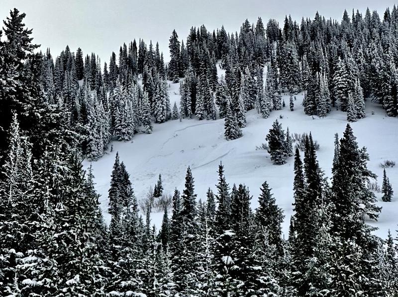
Yesterday, there was one skier-triggered avalanche reported from Providence Canyon. This avalanche was unintentionally triggered on a North aspect, at 8700'. It failed as a soft slab sitting on atop facets 2.5' deep. It broke 100' wide and ran 500' in distance. The skier was alerted via radio and able to safely traverse off the avalanche.
Find full observation HERE.

Several people ventured into the backcountry terrain on the Beaver Backside last Wednesday and some reported collapsing, but no avalanches were reported from the area.
Remember, when you leave the ski area, you are entering the backcountry and you could trigger dangerous avalanches.

***See our updated list of observed avalanches from across Utah HERE
Ad
Avalanche Problem #1
Persistent Weak Layer
Type
Location
Likelihood
Size
Description
We've found buried layers of sugary snow at all elevations and on slopes facing every direction. The persistent weak layer (PWL) problem has the potential to get worse as widespread slopes with poor snow structure are overloaded, and the problem is likely to be an issue for a while. This afternoon, we are adding two huge stressors to this fragile snowpack in the form of heavy snowfall and elevated winds. We can't know if this will be the tipping point that will cause the snowpack to become unglued, but we do know that the avalanche danger and likelihood of avalanches will be on the rise again.
  • Areas plagued by a very sensitive PWL consisting of buried feathers of surface hoar are also widespread, but we've found them mostly in sheltered low and mid-elevation terrain. Persistent weak layers consisting of surface hoar are notoriously tricky, often surprising and sometimes catching experienced avy pros off guard. Avalanches failing on buried surface hoar may occur on lower angled slopes than you might expect.
  • Red Flags indicating a persistent weak layer instability will include audible collapses or wumpfs and shooting cracks. Sometimes no red flags are apparent and you have to dig down into the snow to find the sugary weak layer.
  • Slab avalanches failing on a buried persistent weak layer could be remotely triggered from a distance, hopefully not from below.
Avalanche Problem #2
Wind Drifted Snow
Type
Location
Likelihood
Size
Description
Over the last 24 hours, the southwesterly winds have remained elevated. These strong winds in combination with snow available for transport will have drifted snow and formed fresh slabs.
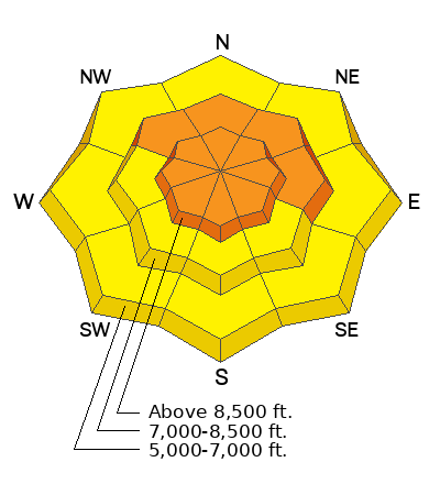
Sustained high winds can deposit snow around terrain features on almost any aspect, called cross-loading. For this reason, I would expect to find slabs of wind-drifted snow forming at all mid and upper-elevation slopes, especially along terrain features such as ridgelines, sub-ridges, and gullies that allow for snow to catch and accumulate. These wind drifts will be particularly touchy on aspects facing northwest through north through east due to the direction of the wind. Any avalanche triggered within the wind-drifted snow can step down into deeper weaker layers creating a much larger avalanche.
Today look for slopes with any signs of wind-drifted snow, such as cracking, hollow noises, and pillow-shaped snow, and avoiding those slopes.
In zones protected from the wind, we could begin to see some avalanches within the new snow later this afternoon. While overall snow totals are important, what we truly pay attention to is what RATE snowfalls and how quickly it loads the snowpack. We call this precipitation intensity, and if those rates stay elevated or increase sooner than expected we could see the avalanche danger spike and more new snow avalanches occurring.
During times of high precipitation intensity, both fast-running sluffs and soft slab avalanches could become possible by the later afternoon and early evening.
Additional Information
Take the all-new online avalanche courses the UAC built for Know Before You Go or take other online courses listed on the KBYG website (Develop skills -> Online Learning).

Get your avalanche rescue gear ready for winter.
  • Put fresh batteries in your transceiver and update the firmware.
  • Inspect your shovel and probe.
  • Get your airbag backpack ready by possibly doing a test deployment and update the firmware if it is an electric version.
  • Practice Companion Rescue with your backcountry partners.
General Announcements
Please submit your observations from the backcountry HERE.
For a list of avalanche classes from the Utah Avalanche Center go HERE
For information on where you can ride your sled or snowbike, check out this map of the winter travel plan for the Tony Grove and Franklin Basin Areas HERE.
The Tony Grove Road and other forest roads in the Logan Ranger District are not maintained for wheeled vehicles in the winter.
This information does not apply to developed ski areas or highways where avalanche control is normally done. This forecast is from the U.S.D.A. Forest Service, which is solely responsible for its content. This forecast describes general avalanche conditions and local variations always occur.