Check out our Holiday Auction

Forecast for the Logan Area Mountains

Nikki Champion
Issued by Nikki Champion on
Saturday morning, December 10, 2022
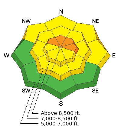
The avalanche danger is CONSIDERABLE on steep upper elevation slopes facing northwest, north, northeast, and east, where yesterday's new snow and elevated westerly, and southwesterly winds have created both soft slabs of freshly wind-drifted snow and previously drifted hard slabs 1-3' deep. Avalanches that are initially triggered within the wind-drifted snow can step down into the widespread buried persistent weak layer. Conservative decision-making will be essential today.
The avalanche danger is MODERATE on upper-elevation slopes facing west, southwest, south, and southeast, all mid-elevation slopes, and low-elevation slopes facing northwest, north, northeast, and east.

You'll find nice powder and much safer conditions in lower-angle terrain, sheltered slopes, and at lower elevations.
Low
Moderate
Considerable
High
Extreme
Learn how to read the forecast here
Special Announcements
Thanks for showing up Tuesday night and supporting the UAC. It was great to see everybody at the Cache! You made our annual Pray for Snow party/fundraiser a big success.

Join the Utah Avalanche Center and the Division of Outdoor Recreation to celebrate the Fourth Annual Avalanche Awareness week, from December 4 - December 11. Click HERE to view the full list of events for the week.
Today's Beacon Clinic location has been moved. Due to the early opening of Beaver Mountain and adequate snow in the valley, the clinic will be held at USU Aggie Legacy Fields on the north side of the USU ARC. Parking is to the east of the fields.
Weather and Snow
Last week's heavy snow and drifting overloaded many slopes plagued by buried weak layers and poor snow structure. Dangerous human-triggered avalanches remain possible for people to trigger, especially on previously drifted upper and mid-elevation slopes. Fresh drifts could be very sensitive and we can expect to see people triggering avalanches of wind-drifted snow today at upper elevations. It's possible that a small avalanche overrunning a slope with poor snow structure could step down into sugary November snow and create a much larger hard-slab avalanche.
Although much less frequently in the last few days, observers continue to report localized audible collapses or "wumpfs" from across the zone. Collapsing indicates unstable snow and real potential for dangerous slab avalanches failing on a buried persistent weak layer.

This morning, temperatures are in the upper teens and low 20° Fs. Skies are overcast and winds are blowing from the west-southwest at speeds of 15-25 mph with gusts near 35 mph.
Today, skies will remain overcast and the temperatures will climb into the upper 20° Fs. It will continue to be rather breezy throughout the day, with 15 to 25 mph southwesterly winds, and gusts around 35 mph.
Avalanche danger will surely rise later this weekend, as a prolonged period of snowy weather is expected to begin Saturday night through early next week. This storm brings the potential for substantial accumulation.
Recent Avalanches
No new avalanches were reported in the backcountry since last weekend when several remotely triggered and some large natural avalanches were reported.
Yesterday, observers noted obvious red flags from Steam Mill, including large "whumps" and obvious wind transport occuring.
Several people ventured into the backcountry terrain on the Beaver Backside on Wednesday and some reported collapsing, but no avalanches were reported from the area.
Remember, when you leave the ski area, you are entering the backcountry and you could trigger dangerous avalanches.

***See our updated list of observed avalanches from across Utah HERE
Ad
Avalanche Problem #1
Persistent Weak Layer
Type
Location
Likelihood
Size
Description
We've found buried layers of sugary snow at all elevations and on slopes facing every direction. The persistent weak layer (PWL) problem has the potential to get worse as widespread slopes with poor snow structure are overloaded, and the problem is likely to be an issue for a while.
Areas plagued by a very sensitive PWL consisting of buried feathers of surface hoar are also widespread, but we've found them mostly in sheltered low and mid-elevation terrain. Persistent weak layers consisting of surface hoar are notoriously tricky, often surprising and sometimes catching experienced avy pros off guard. Avalanches failing on buried surface hoar may occur on lower angled slopes than you might expect.
  • Red Flags indicating a persistent weak layer instability will include audible collapses or wumpfs and shooting cracks. Sometimes no red flags are apparent and you have to dig down into the snow to find the sugary weak layer.
  • Slab avalanches failing on a buried persistent weak layer could be remotely triggered from a distance, hopefully not from below.

Poor Snowpack structure found on a Southwest aspect off the Beaver Creek road. Find full observation HERE.
Avalanche Problem #2
Wind Drifted Snow
Type
Location
Likelihood
Size
Description
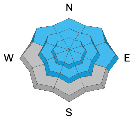
Over the last 24 hours, the west and southwesterly winds began to pick up. With new snow available for transport, even a small bump in winds will begin drifting snow. Sustained high winds can deposit snow around terrain features on almost any aspect, called cross-loading. For this reason, I would expect to find slabs of wind-drifted snow forming at all upper-elevation slopes, especially along terrain features such as ridgelines, sub-ridges, and gullies that allow for snow to catch and accumulate. These wind drifts will be particularly touchy on aspects facing northwest through north through east due to the direction of the wind, and where the wind drifted snow will be sitting on top of the weak faceted snow. Any avalanche triggered within the wind drifted snow can step down into deeper weaker layers creating a much larger avalanche.
Today look for slopes with any signs of wind drifted snow, such as cracking, hollow noises, and pillow-shaped snow, and avoiding those slopes.
Additional Information
Take the all-new online avalanche courses the UAC built for Know Before You Go or take other online courses listed on the KBYG website (Develop skills -> Online Learning).

Get your avalanche rescue gear ready for winter.
  • Put fresh batteries in your transceiver and update the firmware.
  • Inspect your shovel and probe.
  • Get your airbag backpack ready by possibly doing a test deployment and update the firmware if it is an electric version.
  • Practice Companion Rescue with your backcountry partners.
General Announcements
Please submit your observations from the backcountry HERE.
For a list of avalanche classes from the Utah Avalanche Center go HERE
For information on where you can ride your sled or snowbike, check out this map of the winter travel plan for the Tony Grove and Franklin Basin Areas HERE.
The Tony Grove Road and other forest roads in the Logan Ranger District are not maintained for wheeled vehicles in the winter.
This information does not apply to developed ski areas or highways where avalanche control is normally done. This forecast is from the U.S.D.A. Forest Service, which is solely responsible for its content. This forecast describes general avalanche conditions and local variations always occur.