Check out our Holiday Auction - Sign Up for the Utah Snow and Avalanche Workshop (USAW)

Forecast for the Moab Area Mountains

Dave Garcia
Issued by Dave Garcia on
Wednesday morning, December 7, 2022
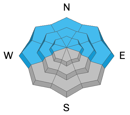
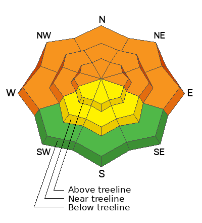
With new snow and moderate winds the avalanche danger will rise to CONSIDERABLE today on all slopes that face W-N-E. Dangerous conditions are developing in the backcountry and natural avalanches failing on a buried persistent weak layer will be possible and human triggered avalanches are likely. There is a MODERATE danger of triggering an avalanche in wind drifted snow near treeline and above on all aspects.
With the danger on the rise, do not try to outsmart today's avalanche problems. Stick to low angle terrain with nothing steep above you.
Low
Moderate
Considerable
High
Extreme
Learn how to read the forecast here
Special Announcements
Join us for the 1st Annual UAC Moab/LUNA Winter Kickoff Party on Saturday, Dec 10 at the MARC. The event will be from 7-9 PM. Get your tickets here.
The Utah Avalanche Center wants to give you free batteries for your beacons. Head on over to Moab Gear Trader to pick up your free batteries. While you are there, scan a QR code to fill out a quick survey and be entered to win some avalanche rescue gear.
Join the Utah Avalanche Center and the Division of Outdoor Recreation to celebrate the Fourth Annual Avalanche Awareness Week, from December 4 - December 11. Click HERE to view a full list of events throughout the state.
Road Conditions: Grand County has not yet begun plowing the road to Geyser Pass Trailhead. The road is hard-packed snow and slick in places. Good tires and all wheel drive are recommended.
Grooming: The Geyser Pass Road above the winter trailhead closes on Dec 15. Grooming will commence after that, but but for now, the road above the trailhead is snowpacked and well traveled and cross country ski conditions are pretty good.
Weather and Snow
24 Hour Snow 5" 72 Hour Snow 5" Season Total Snow 46" Base Depth at Gold Basin 27"
Winds on Pre Laurel Peak SSE 7 G 9 Temp 19F
A mild southerly flow will continue to affect the La Sals and four corners region today and tonight. After a break in the action yesterday afternoon, snowfall started again around 4 AM. The next 12 hours should bring us 4-6" of snow, with an additional 4-6" falling tonight. When it's all said and done storm totals by Thursday morning will be 12-16" with an inch of water. Thursday and Friday will be sunny with our next chance for snow on Sunday.
Five inches of snow fell yesterday morning. SW winds were light and skiing and riding conditions will be good this morning and will get even better as the day goes on. The new snow will blanket a mix of scoured slopes and old hard wind drifts in the alpine. These drifts overlie a base of very weak faceted snow. I do not have much confidence in this very weak snow structure. Snow will continue to pile up today. As storm totals increase we will see a corresponding rise in avalanche danger. It's also still low tide out there with lots of rocks, stumps, and logs lurking about.
Gold Basin Storm Stake (10,000')
Gold Basin SNOTEL site (10,000')
SNOTEL site near Geyser Pass Winter Trailhead (9600')
Wind Station on Pre-Laurel Peak (11,400')
NWS forecast for the La Sal Mountains.
If you are getting up into the mountains please submit an observation and let us know what you are seeing!
Recent Avalanches
A list of avalanches for the La Sal Range can be viewed here
Ad
Avalanche Problem #1
Persistent Weak Layer
Type
Location
Likelihood
Size
Description
A cold dry period for two and half weeks in mid November resulted in a very weak snowpack. A persistent weak layer of faceted snow developed at all elevations on aspects facing W-N-E. This weak foundation of snow was buried by seven inches of new snow on 11/29. Yesterday morning we added five inches of snow and half an inch of water. Today's storm will continue to add more weight and stress on top of buried weak layers. The slab is slowly building on top of a very fragile snowpack. Small incremental loading can create deceptively dangerous avalanche conditions. Rather than bringing it all down at once, we slowly add stress to the snowpack until finally it fails. Audible collapsing and cracking are obvious signs that the weak snow is failing. Today is a good day to stick to low angle slopes and dense trees. This storm is going to be the first real test of this buried persistent weak layer. The best strategy is to not mess around with it and give the snowpack time to adjust to the new load. We could see a natural avalanche cycle starting later today and tonight.
Avalanche Problem #2
Wind Drifted Snow
Type
Location
Likelihood
Size
Description
South winds will pick up once again as the storm continues. Southerlies will blow in the 15-20 mph range. There will be plenty of new snow available for transport. Look for fresh slabs of wind drifted snow developing near treeline and above. Wind drifted snow has the potential to form on any aspect, but fresh drifts will be most obvious on leeward slopes that face W-N-E.
  • Fresh drifts or wind slabs are often smooth and round looking.
  • Wind slabs often form on the lee side of exposed ridges and in and around terrain features. Watch for and avoid drifts on gully walls, under cliff bands, along sub-ridges, in scoops, saddles, and sinks.
  • Wind drifted snow is stiffer and more cohesive than non drifted snow. Hard drifts can sound hollow and drum like.
  • Fresh slabs of wind drifted snow on top of a buried persistent weak layer will only make conditions more dangerous. In these areas you can trigger a bigger, deeper, wider, and more dangerous avalanche.
Additional Information
General Announcements
This forecast is from the U.S.D.A. Forest Service, which is solely responsible for its content. This forecast describes general avalanche conditions and local variations always occur.