Join us at our 2nd Annual Blizzard Ball

Forecast for the Provo Area Mountains

Drew Hardesty
Issued by Drew Hardesty on
Thursday morning, April 7, 2022
A MODERATE danger exists in the upper elevations of the Provo mountains. Human triggered avalanches are possible. Watch for shallow wet loose avalanches on the steep sunlit slopes with daytime warming.
Low
Moderate
Considerable
High
Extreme
Learn how to read the forecast here
Special Announcements
Weather and Snow
Skies are clear.
Mountain temperatures are in the mid-20s. Northwest winds are blowing 15mph with gusts to 20. Along the 11,000' level, winds are blowing 30-35mph with gusts to 50.
Fair and mild conditions are expected today and tomorrow ahead a series of increasingly cold and wet storms slated for this weekend and into next week.
Backcountry travel is easy and fun with a few inches of dense snow and some wind-effect capping myriad crusts. Southerly aspects will have a short lived crust this morning that will soften with daytime warming.

A sharp but dry cold front slices through Utah Saturday, dropping mountain temperatures to the low single digits by Sunday. This paves the way for an what looks to be a wet and stormy pattern for the week. Stay tuned.
Recent Avalanches
None. The Provo area mountains shed a lot of avalanches over the past week and a half, primarily due to the excessive heat and record breaking temperatures two weekends ago. Natural avalanches are easy to see from the high country.

Find all observations HERE.
Ad
Avalanche Problem #1
Wind Drifted Snow
Type
Location
Likelihood
Size
Description
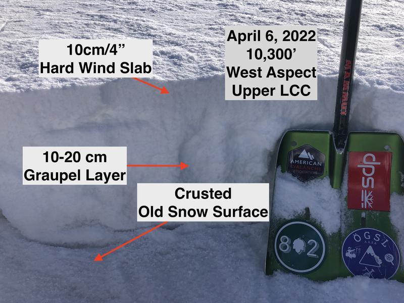
Pockets of wind slab exist in isolated terrain. Greg's snow profile from yesterday in the central Wasatch mirrors the Provo conditions and his comments are worth repeating: "Getting caught in a small avalanche involving a wind drift that fails in the graupel and runs on the slick crust as a bed surface where it would be difficult to self-arrest could be consequential in very steep, rocky terrain."
On upper elevation northerly slopes, any avalanche may potentially step down to a strengthening layer of facets (PWL) 1-2' deep.

My partner and I traveled through the south fork of Big Springs yesterday and our observation can be found HERE> .
General Announcements
Who's up for some free avalanche training? Get a refresher, become better prepared for an upcoming avalanche class, or just boost your skills. Go to https://learn.kbyg.org/ and scroll down to Step 2 for a series of interactive online avalanche courses produced by the UAC.
This information does not apply to developed ski areas or highways where avalanche control is normally done. This forecast is from the U.S.D.A. Forest Service, which is solely responsible for its content. This forecast describes general avalanche conditions and local variations always occur.