Check out our Holiday Auction

Forecast for the Logan Area Mountains

Toby Weed
Issued by Toby Weed on
Saturday morning, January 22, 2022
In the Central and Northern Bear River Range, in sheltered terrain and at lower and mid elevations, the snow is stable, the danger LOW, and avalanches are unlikely. However, heightened avalanche conditions and MODERATE danger may exist at upper elevations in the Wellsville Range, the Southern Bear River Range, and the Logan Peak Area, where people might trigger shallow slab avalanches of wind drifted snow.
  • Use normal caution.
  • Also, evaluate snow and terrain carefully in drifted upper elevation terrain.
Low
Moderate
Considerable
High
Extreme
Learn how to read the forecast here
Special Announcements
Thanks to the generous support of our local resorts and Ski Utah, discount lift tickets are now available. Support the UAC while you ski at the resorts this season. Tickets are available HERE
Weather and Snow
The 8400' Tony Grove Snotel reports 18°F, and there is just under 6 feet (71 inches) of total snow at the site containing 128% of normal SWE for the date. Winds out of the northwest are blowing around 10 mph this morning at the 9700' CSI Logan Peak weather station. Expect sunny skies and fair weather in the mountains today, continuing through weekend and beyond. High temperatures around 27°F are expected at 8500' today, dropping with clearing skies tonight to around 14°F. Moderate northeast winds are expected today, veering more from the east tonight.

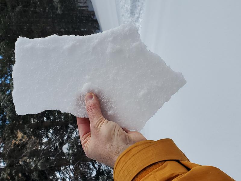
A few inches of new snow didn't change avalanche conditions much, but it capped and preserved weak surface snow created in many areas by high pressure conditions in the last couple weeks. Thursday night, winds drifted the few inches of fresh snow around at upper elevations, but a thin rime-crust formed on the snow surface (at least in the Central and Northern Bear River Range) and this appears to be gluing the shallow drifts in place.
Observers report a widespread thin rime-crust on the new snow surface in the Central and Northern Bear River Range.

I started up into East Banks (across from Red Banks) in Logan Canyon Thursday to look at the snow. Right away I encountered horrible snow conditions with the thick crust from the 1-6 rainstorm no longer supportable, but now a widespread brittle breakable crust capping a thick layer of very weak dry faceted snow. Needless to say, I didn't go very far.
Recent Avalanches
Due to the benign January weather it's been a couple weeks since any significant avalanche activity occurred in the Logan Zone.

Check HERE for all the latest observations and avalanche activity.
Ad
Avalanche Problem #1
Wind Drifted Snow
Type
Location
Likelihood
Size
Description
A few inches of new snow from Thursday night hasn't changed avalanche conditions much, but westerly winds were plenty strong enough to drift the fresh snow around at upper elevations. In many areas a thin rime-crust formed on the snow surface and appears to be holding things together, but people still might trigger stubborn shallow slabs of wind drifted snow up to about a foot deep on upper elevation slopes steeper than 30°. Yesterday's rime-crust was reported in the Central and Northern Bear River Range, but it was not reported in the Ogden Zone, and it may not be present in the Logan Peak Area, Southern Bear River Range, or the Wellsville Mountain Wilderness.
  • Watch for and avoid fresh drifts, corniced slopes, and stiffer wind drifted snow in and around terrain features like sub-ridges, gully walls, and cliff bands.
  • Avoid travel on drifted steep slopes above terrain traps like trees or benches.
Avalanche Problem #2
Normal Caution
Type
Location
Likelihood
Size
Description
  • Although increasingly unlikely as time passes, people still might trigger dangerous avalanches breaking several feet deep on faceted snow near the ground on isolated slopes steeper than 30°. Watch for and avoid very steep slopes with thin snow cover (3 feet or less), especially if you sink into weak snow or can poke your ski pole through loose snow to the ground.
  • It is important to stay in the habit of practicing safe backcountry travel protocols by not exposing more than one person at a time to potential avalanches, and convince your riding companions to check and practice with their avalanche rescue equipment.
Additional Information
  • Always follow safe backcountry travel protocols. Go one person at a time in avalanche terrain, (anytime while traveling on or under backcountry slopes steeper than 30°) while the rest of your party watches from a safe area.
  • Check your avalanche rescue equipment, change your batteries, and practice often with your backcountry partners.
    Check slope angles, and to avoid avalanches stay off of and out from under slopes steeper than 30° and adjacent slopes. Video Here
General Announcements
Who's up for some free avalanche training? Get a refresher, become better prepared for an upcoming avalanche class, or just boost your skills. Go to https://learn.kbyg.org/ and scroll down to Step 2 for a series of interactive online avalanche courses produced by the UAC.
  • Check out all the upcoming education classes and clinics HERE.
  • Please submit your observations from the backcountry HERE.
This information does not apply to developed ski areas or highways where avalanche control is normally done. This forecast is from the U.S.D.A. Forest Service, which is solely responsible for its content. This forecast describes general avalanche conditions and local variations always occur.