Check out our Holiday Auction

Forecast for the Logan Area Mountains

Toby Weed
Issued by Toby Weed on
Saturday morning, January 15, 2022
The snow is stable, the danger LOW, and avalanches are unlikely. Low danger does not mean no danger. Loose wet avalanches are possible in the heat of the day, especially in sheltered sunny terrain. Although unlikely, people still might trigger dangerous avalanches breaking several feet deep on faceted snow near the ground on isolated upper elevation slopes steeper than 30°.
Use normal caution.
Low
Moderate
Considerable
High
Extreme
Learn how to read the forecast here
Weather and Snow
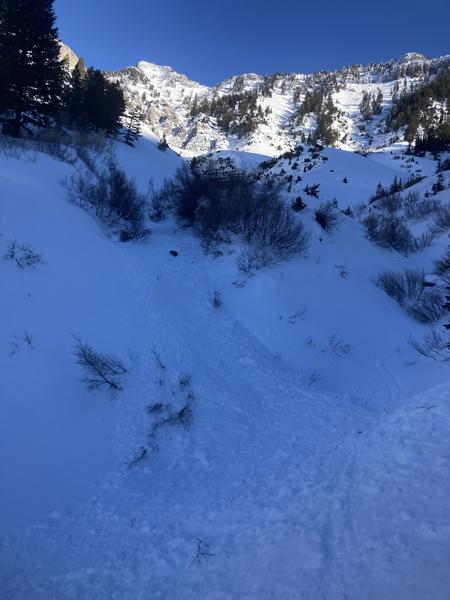
You don't sink into the deep supportable snow more than a couple inches in most places. Even if you get off you sled, your don't sink in all that far, and it's pretty easy to walk around in boots in many areas. We found a rain-crust all the way to the top of Beaver Mountain from last week's storm (1-6-2022), now capped by a dusting to couple inches of frosty recrystallized powder. We found apparently stable snow at upper elevations in the Central Bear River Range, with easy traveling conditions on a mostly firm snow surface. The terrain is now nicely filled in and smoothed out. Many rock outcroppings and smaller cliff bands are completely covered by a heavy blanket of thick and now pretty hard snow from last week's monsoon and last year's Holiday storms.
Here is what we found on Thursday in the Cornice Ridge Area, west of Tony Grove Lake.

The 8400' Tony Grove Snotel reports 23°F this morning and there is 74 inches of total snow containing 146% of average SWE for the date. Winds out of the northwest are blowing around 20 mph this morning at the CSI Logan Peak weather station. Expect fair weather in the mountains again today, continuing through the weekend and beyond. High temperatures at 8500' will be around 30°F today and will drop to around 14°F tonight. Tomorrow's weather will be similar to today's, with temperatures topping out around 27°F. Our next chance for a little snow comes in the middle of the week, on Wednesday.
Unfortunately, weak layers form and become weaker during high pressure weather conditions, with dry air and cold clear nights. A weak sugary layer will continue to develop on the snow surface right above Thursday's hard rain-crust, and sugary faceted snow near the ground will continue to grow and weaken where snow cover is shallow.
Recent Avalanches
Heavy snow, wind drifting, and rain on snow caused many natural avalanches to occur during last week's storm across the zone. Since then no significant new avalanches were reported, and it's been about 3 weeks since any deep avalanches failing on that nasty sugary buried persistent weak layer near the ground occurred in the Logan Zone.

Yesterday, an observer spotted some fresh minor loose wet activity in the Cherry Creek Area in the Mount Naomi Wilderness.
Check HERE for all the latest observations and avalanche activity.
Ad
Avalanche Problem #1
Normal Caution
Type
Location
Likelihood
Size
Description
Dangerous deep hard slab avalanches are unlikely. Avoid very steep rocky slopes with shallow snow cover where you sink into weak sugary faceted snow. The deeply buried persistent weak layer is apparently dormant, and it's unlikely that a person could trigger a dangerous avalanche breaking on sugary snow near the ground. Isolated very steep rocky slopes with thin snow cover are the most suspect, and you might have to dig down into the snow to find weak faceted snow or poor snow structure. Small loose wet avalanches are possible in sheltered sunny terrain in the middle of the day, especially around rocks or cliffs.
LOW danger means the snow is stable and avalanches are unlikely on most slopes in the backcountry, but whenever you venture into the mountains you need to use your head and travel with caution. It'll be a great weekend to get out into the backcountry and enjoy fantastic weather and great views. There is not much powder to be found these days, but there is some nice soft recrystallized surface snow in sheltered upper elevation terrain. Supportable snow makes for easy and fast travel up high, but a breakable crust makes midday travel a bit more challenging at low and mid elevations.

  • Get in the habit of always practicing safe backcountry travel protocols by not exposing more than one at a time to avalanche risk, and convince your traveling companions to practice with their avalanche rescue equipment.
Additional Information
  • Always follow safe backcountry travel protocols. Go one person at a time in avalanche terrain, while the rest of your party watches from a safe area.
  • Check your avalanche rescue equipment, change your batteries, and practice often with your backcountry partners.
    Check slope angles, and to avoid avalanches stay off of and out from under slopes steeper than 30° and adjacent slopes. Video Here
General Announcements
Who's up for some free avalanche training? Get a refresher, become better prepared for an upcoming avalanche class, or just boost your skills. Go to https://learn.kbyg.org/ and scroll down to Step 2 for a series of interactive online avalanche courses produced by the UAC.
  • Check out all the upcoming education classes and clinics HERE.
  • Please submit your observations from the backcountry HERE.
This information does not apply to developed ski areas or highways where avalanche control is normally done. This forecast is from the U.S.D.A. Forest Service, which is solely responsible for its content. This forecast describes general avalanche conditions and local variations always occur.