Check out our Holiday Auction

Forecast for the Logan Area Mountains

Toby Weed
Issued by Toby Weed on
Sunday morning, January 2, 2022
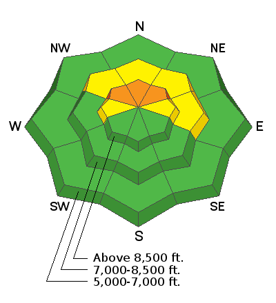
Areas with dangerous avalanche conditions and CONSIDERABLE danger exist at upper elevations on slopes facing the northern half of the compass. People are likely to trigger dangerous avalanches breaking 4 to 6 feet deep on a buried persistent weak layer near the ground if they venture into steep terrain in these areas. Conditions are much safer, there is LOW danger, and the snow is generally stable on slopes that were bare or only shallowly covered when snow started falling at the beginning of December, including most sunny and lower elevation slopes.
  • Careful snowpack evaluation, cautious route-finding, and conservative decision making are essential for safe travel in the backcountry today.
  • Continue to avoid and stay out from under steep upper elevation slopes facing northwest, north, and northeast.
Low
Moderate
Considerable
High
Extreme
Learn how to read the forecast here
Weather and Snow
With beautiful sunny skies and so much fresh powder, today is ripe for accidents. Please don't let all the beautiful powder lure you into forgetting about the dangers lurking beneath. Continue to stay away from high north-facing terrain where avalanches are likely. There is plenty of great powder everywhere and many safer terrain options to ride. Now is the time to ride in the sunshine on south-facing slopes. Better yet, ride in the meadows and on slopes less than 30 degrees in steepness with nothing steeper above.
The Holiday storms dumped several feet of snow across the Logan Zone, and brought snow totals back up to well above normal for this time of year. There is now 64"of total snow at the 8400' Tony Grove Snotel, containing 109% of normal SWE for the date. I'm reading -11°F at the Hwy 89 summit sheds and 3°F at the summit of Logan Peak, where westerly winds are blowing about 25 mph.

Today will be sunny and cold, with high temperatures at 8500' rising to about 18°F, 14 to 21 mph west-southwest winds, and wind chill values as low as -17°F! Southwest winds will increase tomorrow ahead of more snowy weather Tuesday, continuing through the work week, with significant accumulations likely in the mountains.
Recent Avalanches
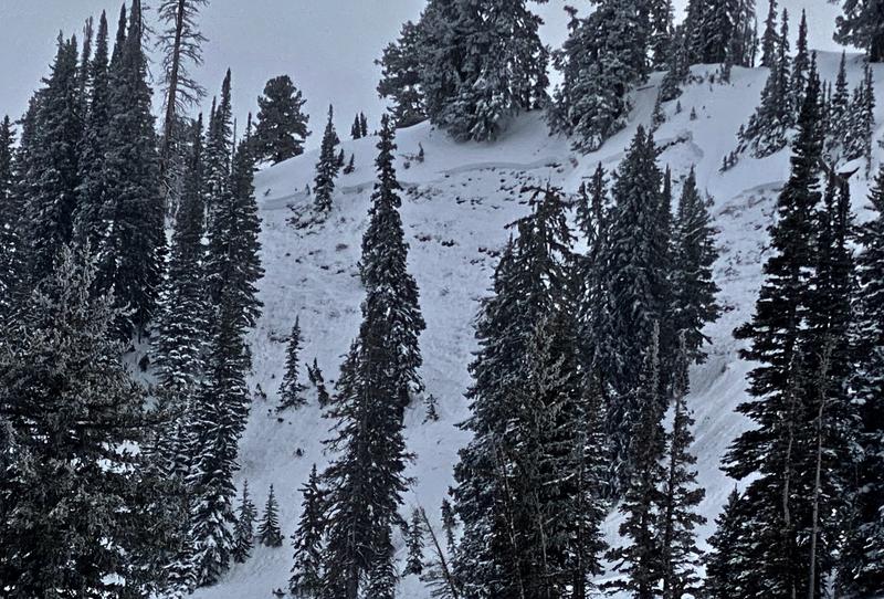
There were several natural avalanches that happened on Providence Peak earlier this week like the one below.

Check HERE for all the latest observations and avalanche activity.
Ad
Avalanche Problem #1
Persistent Weak Layer
Type
Location
Likelihood
Size
Description
I will continue to avoid mid and upper elevation northerly facing slopes. These slopes have a buried persistent weak layer of weak, sugary facets near the ground that could fracture and produce slab avalanches 4-6 feet deep and hundreds of feet across. Avalanches could be triggered remotely, from a distance or from flat terrain under steep slopes. It's a very different situation at lower elevations and on south facing slopes where this persistent weak layer near the ground doesn't exist.
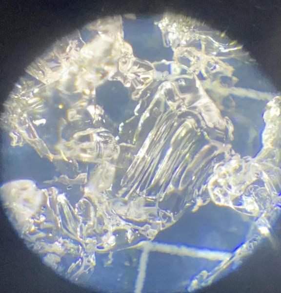
The photo below is a close up of what the faceted snow looks like. Notice the striations or straight lines that form when the snow crystals change into a weak faceted crystal. Cold temperatures like today's cause a temperature gradient in the snowpack and these sugary snow crystals to develop. I am noticing rapid development of faceted snow at low elevations these days, especially where the existing snow is still shallow.
Additional Information
  • Always follow safe backcountry travel protocols. Go one person at a time in avalanche terrain, while the rest of your party watches from a safe area.
  • Check your avalanche rescue equipment, change your batteries, and practice often with your backcountry partners
General Announcements
Who's up for some free avalanche training? Get a refresher, become better prepared for an upcoming avalanche class, or just boost your skills. Go to https://learn.kbyg.org/ and scroll down to Step 2 for a series of interactive online avalanche courses produced by the UAC.
  • Check out all the upcoming education classes and clinics HERE.
  • Please submit your observations from the backcountry HERE.
This information does not apply to developed ski areas or highways where avalanche control is normally done. This forecast is from the U.S.D.A. Forest Service, which is solely responsible for its content. This forecast describes general avalanche conditions and local variations always occur.