Join us at our 2nd Annual Blizzard Ball

Forecast for the Provo Area Mountains

Greg Gagne
Issued by Greg Gagne on
Friday morning, December 17, 2021
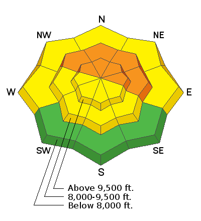
There is a CONSIDERABLE avalanche danger on slopes steeper than 30° at the mid and upper elevations on aspects facing northwest through north and east where recent storm snow and wind-blown snow has overloaded a layer of faceted snow down near the ground. Avalanches may break down 2-3' deep and propagate hundreds of feet wide.
Other than low-elevation southerly aspects which have a Low danger, there is a Moderate danger on all other aspects where you may encounter fresh wind drifts or sluffing in the low-density storm snow.

Fortunately, several days of regular snowfall, cold temperatures, and a low sun angle are providing excellent riding conditions on southerly aspects as well as lower-angled slopes on northerly aspects that are not below or connected to steeper slopes.
Low
Moderate
Considerable
High
Extreme
Learn how to read the forecast here
Weather and Snow
Currently: Skies are overcast and a few additional inches of snow fell overnight. Winds are out of the west/northwest and along 10,500' ridges are averaging in the teens with gusts in the 20's mph. Winds at 11,000' are averaging in the 30's mph with gusts in the 40's and 50's mph. Temperatures average from the high single digits to mid teens.
Storm snow and water totals over the past 36 hours are approaching a foot with nearly an inch of water.
For today, temperatures will climb into the teens and the west/northwest winds will slowly diminish throughout the day, averaging in the low teens with gusts in the 20's mph along mid-elevation ridges. Along the highest elevation ridgetops at 11,000' winds will average in the 20's with gusts in the 40's. We may pick up a trace to a few inches of snow this morning before skies begin to clear out ahead of a weekend of sunshine.
Recent Avalanches
Although centric to the Salt Lake mountains, our first Week in Review has been published, featuring significant avalanche activity and weather events over the past week.

No backcountry avalanches were reported from the Provo mountains on Thursday. Further north in the Salt Lake mountains two avalanches were reported from the backcountry on Thursday:
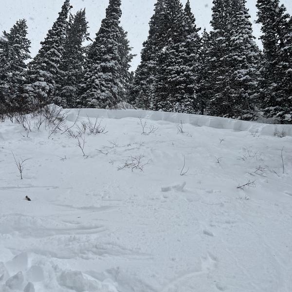
- Pink Pine - 2' deep 125' wide. (photo below)
- Main Porter Fork - 2' deep 150' wide.
Both were skier-triggered, failing on the layer of Autumn Facets.
Wednesday was a very active day with 10 backcountry avalanches in the Salt Lake mountains reported to the UAC. This includes a near-miss in Hidden Canyon in the Brighton Backcountry. Drew visited the site yesterday and his video tells the story of this near-miss accident as well as the dangerous conditions on slopes where the persistent weak layer is present.
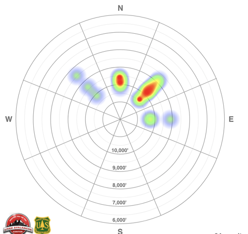
The following heat map shows the distribution of avalanche activity in the Salt Lake mountains since Thursday, December 9:
Ad
Avalanche Problem #1
Persistent Weak Layer
Type
Location
Likelihood
Size
Description
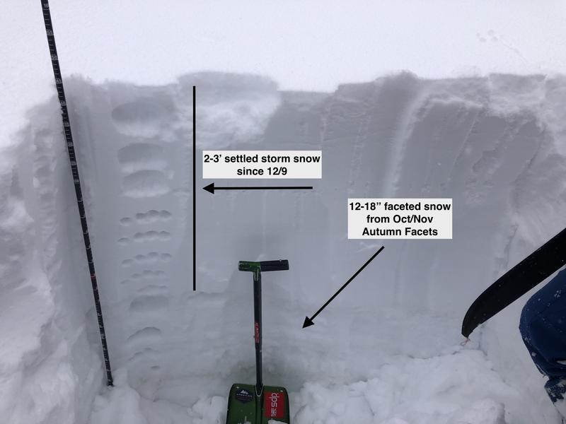
Dangerous avalanche conditions exist on mid and upper elevation slopes steeper than 30° on aspects facing northwest through east where 2-3' of storm snow and wind-blown snow over the past 9 days have overloaded weak, faceted snow (a persistent weak layer, or PWL) in the bottom of the snowpack. Avalanches may break down 2-3' deep (possibly deeper) and propagate hundreds of feet wide. The photo below illustrates this structure:
Avalanches may be triggered remotely (from a distance) and may break well above you. Existing tracks are no indication of stability. What concerns me is that the snowpack is slowly becoming a little less reactive - perhaps fewer collapses, maybe fewer remotely-triggered avalanches - providing a false sense of a stable snowpack. Don't be lulled into this sort of thinking - conditions are dangerous on aspects where the PWL is present.
My advice is simple: do not travel on or underneath slopes steeper than 30° at the mid and upper elevations on slopes facing northwest through north and east.
General Announcements

This information does not apply to developed ski areas or highways where avalanche control is normally done. This forecast is from the U.S.D.A. Forest Service, which is solely responsible for its content. This forecast describes general avalanche conditions and local variations always occur.