Forecast for the Provo Area Mountains

Issued by Nikki Champion on
Wednesday morning, December 8, 2021
Wednesday morning, December 8, 2021
For today we have a LOW avalanche danger throughout the mountains of Northern Utah. A LOW avalanche danger means that we generally have safe avalanche conditions. Watch for and avoid unstable snow on isolated terrain features.
As always, carry a transceiver, probe, shovel, and have a partner when in the backcountry. Practice safe travel protocol by only exposing one person at a time to avalanche terrain.
HEADS UP: Avalanche conditions will be rapidly changing over the next few days, with new snow and increased winds the weak snow sitting on Northerly facing terrain will become an issue. When the snowfall does come, the areas that have enough snow to enjoyably ride will be exactly where the problem is.
HEADS UP: Avalanche conditions will be rapidly changing over the next few days, with new snow and increased winds the weak snow sitting on Northerly facing terrain will become an issue. When the snowfall does come, the areas that have enough snow to enjoyably ride will be exactly where the problem is.

Low
Moderate
Considerable
High
Extreme
Learn how to read the forecast here
 Special Announcements
This week is the third annual avalanche awareness week here in Utah. There is a lot going on with over 20 different events around the state. You can find all the events HERE.
 Weather and Snow
Under mostly clear skies, there is an inversion in the mountains. Temperatures range from the low-20s F° at lower elevations, to upper-20s F° at upper elevations. Winds have transitioned to the south-west and are now blowing at speeds of 5-15 mph at mid-elevations and near 30 mph at upper elevation ridgelines.
Today, a winter storm system will begin moving its way into Northern Utah. Temperatures will climb into the low-40s F°, and winds will remain southwesterly averaging 10-20 mph at mid-elevations, with gusts below 25 mph at the highest ridgelines.
Tonight, high-density snow will begin to develop with a mild Southwest flow. By early Thursday morning winds will transition from the south-west to west-north-westerly and with that switch, will come lower density snow and cooler temps. The heaviest snowfall rates will be Thursday morning through early Thursday afternoon. The storm totals are still looking optimistic, with us expecting 14-28" (1.5-2.5" H2O) by Friday evening. Keep your fingers crossed.
Unfortunately, the past 13 days of no new snow has made the riding and turning conditions pretty heinous. Still, one with a strong will can find soft snow in the most wind and sun-protected terrain; otherwise, it's crusts, dirt, and rocks.
 Recent Avalanches
Avalanche Problem #1
Normal Caution
Type
Location

Likelihood
Size
Description
For today, keep an eye out for isolated shallow drifts of wind-blown snow at upper elevations. Watch for and avoid areas with stiff hollow sounding snow. As well, pay attention to any changing conditions, if snowfall begins earlier than expected the avalanche danger will rise as the snowfall rates increase.
HEADS UP: Avalanche conditions will be rapidly changing over the next few days, over the past two weeks, clear and cold nights have subjected our shallow snowpack to a wide variety of temperatures causing it to weaken and become faceted. This weak sugary snow will become an issue once loaded with new storm snow. When the snowfall comes, the areas that have enough snow to enjoyably ride will be exactly where the problem is.
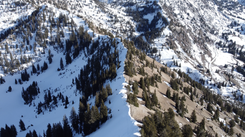
This faceted snow lives on slopes where the old snow from October and November hasn't been able to melt. Look at the photo below; the southerly facing terrain is bare dirt and will pose no threat of avalanches once it snows. Since October, the northerly facing terrain has held snow, becoming a weak layer. Once we load these slopes with new storm snow (slab), they will avalanche. Weak layer + Slab = Avalanche
If we get high snowfall totals, sticking to low angle terrain on the aspects holding snow will be our only option.


