Forecast for the Uintas Area Mountains

Craig Gordon
Issued by Craig Gordon on
Saturday morning, April 3, 2021
As temperatures flirt with record territory and with marginal refreezes on tap... expect the danger of wet avalanches to increase through the weekend
For today-
The snowpack is locked in place this morning, but temperatures soar and the danger of wet avalanches increases to MODERATE on all slopes. As the day wares on human triggered avalanches are POSSIBLE on steep, sun-baked slopes, especially during the heat of the day. So, if the snow you're riding on becomes damp or unsupportable, swing over to a cooler aspect. Or... if the bottom is falling out, simply call it a day.
Low
Moderate
Considerable
High
Extreme
Learn how to read the forecast here
Special Announcements
Sunday, April 4th, will be the last of our regularly scheduled forecasts for the western Uinta Mountains.
Thank you to everyone who helped make our Spring Campaign a huge success. We are grateful for your donations and what they will allow us to accomplish next season. We look forward to continuing to serve you with our forecasting, education, and awareness programs in new and exciting ways.
Weather and Snow
Nowcast-
Skies remained clear overnight, but temperatures barely cooled into the mid and upper 30's where they rest early this morning. Southerly winds are light, blowing just 5-15 mph even along the high peaks. Riding and turning conditions are taking a hard hit and just getting to the snow is a bit of a challenge. However, a legit corn cycle is underway, but you'll have to get to it early today. And remember- the key to a productive corn harvest is to follow the sun, tagging the snow as it warms and becomes more user friendly, but knowing when it's time to leave before the bottom falls out. And while it's not quite like slack-lining, it is a curious balancing act.
Forecast-
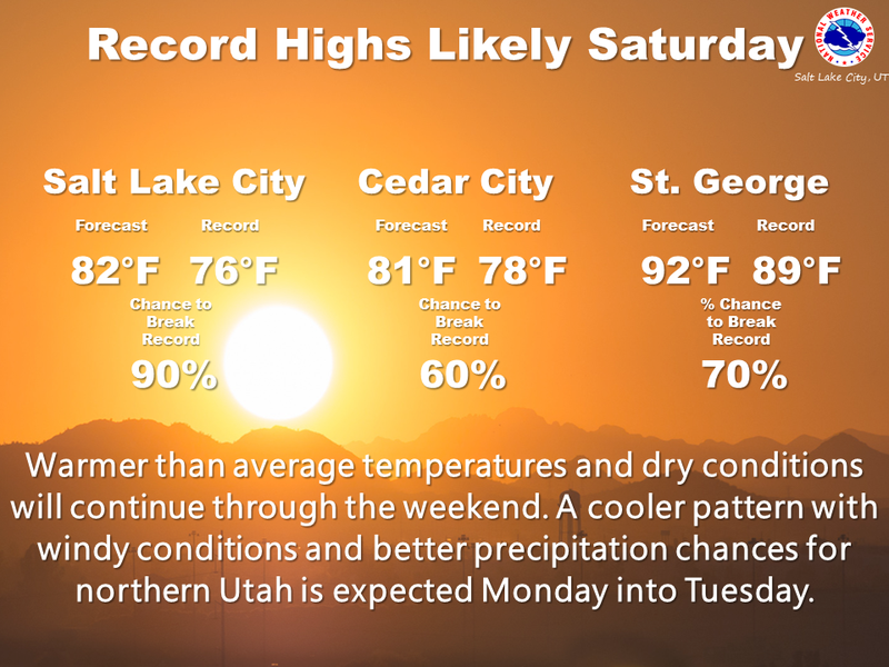
The graphic above says it al... the heat is on! High pressure delivers sunny skies with temperatures quickly climbing into the low to mid 60's later today. Southwest winds remain reasonable and blow in the 20's along the high ridges.
Futurecast-
Sunny, warm, and windy for Sunday with a passing storm system on tap for Monday into Tuesday which delivers cooler temperatures and a light snow shower or two.
Looking for real-time temps, snow, or wind?
Click HERE and then on the "western Uinta" tab for western Uinta specific, weather station network.
Recent Avalanches
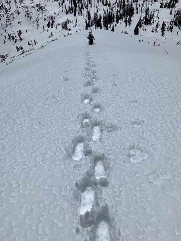
Weston Shirey putting the booter in to access high alpine terrain around the Crystal Lake zone yesterday. He reports.... "Overall we saw about 6" of damp or corn snow sliding on a very hard crust layer just below, while roller balls and active wet loose slides were easy to ski cut on steep south terrain."
You can find a great trip report HERE.

Observations, trip reports, and avalanches found here.
Ad
Avalanche Problem #1
Wet Snow
Type
Location
Likelihood
Size
Description
A few considerations for today...
Wet snow avalanches-
While the pack experienced a deep, solid refreeze earlier this week, the heat is on the next few days and the bottom may start to fall out. And while to snow in upper elevations may remain supportable, think about your exit strategy and remember to avoid terrain traps like road cuts and gullies where heavy, cement-like, tree snapping snow can stack up very deeply. Should the snow you're riding on become damp, manky, or unsupportable, simply switch to a cooler aspect or call it a day and move on to other activities.
Dry snow avalanches-
More the exception than the rule and isolated to steep, leeward terrain in the wind zone, there might be a lingering wind drift or two that'll react to our additional weight. Not particularly widespread, but remember... if you're tagging steep, technical terrain, be aware that even a small slide could knock you off your feet and boss you around. So, the ticket to riding safely today is simply look for and avoid any fat, rounded piece of snow, especially if it sounds hollow like a drum
Additional Information
Yes there's snow up high, but getting to it is becoming an exercise in patience.
I will update this forecast by 7:00 AM tomorrow, Sunday, April 4th.
Your observations are important, so please let me know what you're seeing... click HERE and contribute to this amazing community based program
General Announcements
If you see or trigger an avalanche or just wanna let me know what you're seeing you can reach me directly at 801-231-2170 or craig@utahavalanchecenter.org
This forecast is from the U.S.D.A. Forest Service, which is solely responsible for its content. This forecast describes general avalanche conditions and local variations always occur.