Forecast for the Uintas Area Mountains

Craig Gordon
Issued by Craig Gordon on
Monday morning, March 22, 2021
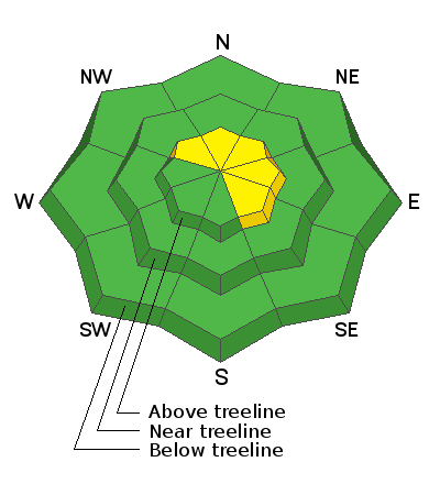
In the wind zone, at and above treeline you'll find MODERATE avalanche danger and human triggered avalanches are POSSIBLE, especially on steep, wind drifted, leeward slopes facing the north half of the compass.
And here's something to consider... if you're getting into steep, technical terrain, even a small slide can knock you off your ride, potentially slam you into a tree, and throw a curve ball at your day.
Lose some elevation and you lose most of the problem. Mid and low elevation wind sheltered terrain offers generally LOW avalanche danger.
Low
Moderate
Considerable
High
Extreme
Learn how to read the forecast here
Special Announcements
Our Spring Avy Awareness Campaign is in full swing from March 16th- March 30th. Please help us save lives through avalanche forecasts and education. Consider making a donation to show your support.
Weather and Snow
Nowcast-
Skies are clear, temperatures in the single digits and low teens, and northerly winds are about as light as they get, blowing less than 10 mph even along the high peaks. Saturday night's storm set its sights on the North Slope, delivering a solid foot of snow, while terrain south of Trial Lake got slightly short-changed, stacking up just half the total storm snow. In either case, riding and turning conditions went from zero to hero, but ya shoulda been here yesterday, as Sunday's strong sunshine kissed most of our terrain and all but high northerlies took on some heat and now offer varying degrees of surface crust.
Forecast-
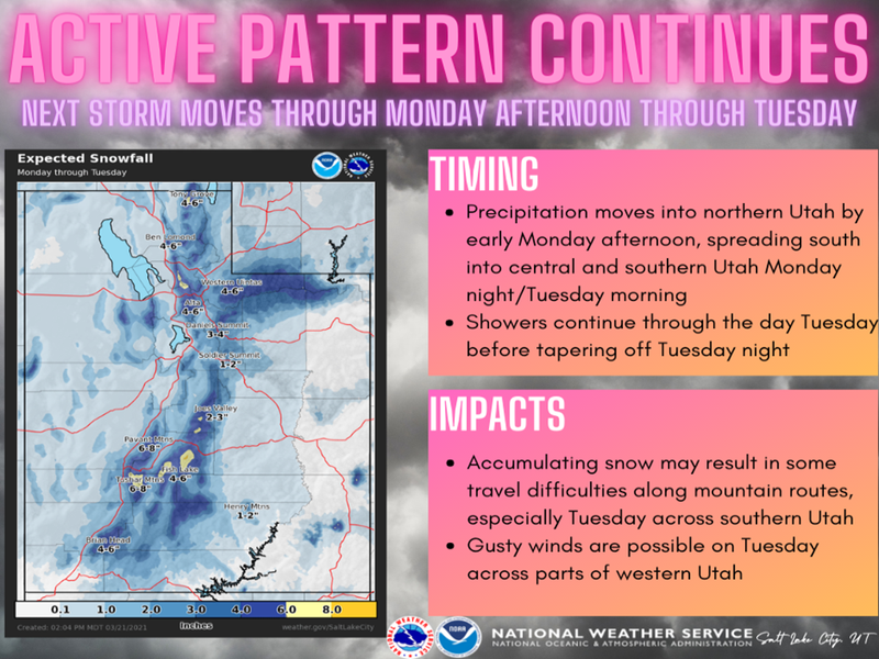
Clouds roll into the area later this morning and light snow showers develop this afternoon as a disorganized storm slides through the region. Temperatures climb into the upper 20's and low 30's and winds shift to the west and northwest, bumping into the 30's late in the day. We can expect a few inches of snow overnight.
Futurecast-
Light snow is on tap for Tuesday, a break in the action Wednesday and another storm slated for Thursday.
Looking for real-time temps, snow, or wind?
Click here and then on the "western Uinta" tab for western Uinta specific, weather station network.
me. Snow begins stacking up in earnest and temperatures dive into the 20's with the arrival of colder, more unstable air. In addition, lightening is a good possibility. A good shot of snow stacks up 8"-10" by the time things wind down overnight.
Recent Avalanches
No significant avalanche activity to report

Observations, trip reports, and avalanches found here.
Ad
Avalanche Problem #1
Wind Drifted Snow
Type
Location
Likelihood
Size
Description
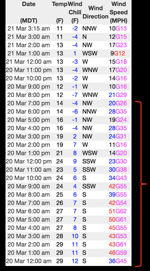
Data in the image above from Windy Peak (10,662') from Saturday into Sunday, clearly illustrates nuking winds through most of the morning along with a midday frontal passage, cooler temperatures, and diminishing winds.
Yesterday, most of our terrain got shrink-wrapped by warm temperatures and strong sunshine. However, there may be a lingering wind drift or two that remains sensitive to our additional weight today. While most of our issues are confined to steep, leeward, upper elevation terrain, Saturday's strong winds cross-loaded terrain features like chutes and gullies and slabs formed lower downslope than we usually expect to see. That's all pretty straight-forward... now here comes the tricky stuff because recent drifts are gonna be camouflaged with fresh snow, making them hard to detect. In any case, today you'll want to look for and avoid fat, rounded pillows of snow, especially if they sound or feel hollow like a drum. And you don't have to ride blind... tweak small test slopes like road cuts to see how they're reacting before tagging big terrain or committing to pre-planned objectives.
Additional Information
I will update this forecast by 7:00 AM tomorrow, Tuesday, March 23rd.
Your observations are important, so please let me know what you're seeing... click HERE and contribute to this amazing community based program
General Announcements
If you see or trigger an avalanche or just wanna let me know what you're seeing you can reach me directly at 801-231-2170 or craig@utahavalanchecenter.org
This forecast is from the U.S.D.A. Forest Service, which is solely responsible for its content. This forecast describes general avalanche conditions and local variations always occur.