Join us at our 2nd Annual Blizzard Ball

Forecast for the Provo Area Mountains

Nikki Champion
Issued by Nikki Champion on
Saturday morning, March 20, 2021
This morning the overall avalanche danger is LOW rising to MODERATE as the storm develops. Today's new snow may produce soft slab avalanches or long-running sluffs. Additionally, the elevated winds may create unstable slabs of wind-drifted snow at mid and upper elevations.
Pay attention to the changing weather and increased snowfall rates, if the snowfall rates increase the sensitivity of the new snow will increase as well.
Low
Moderate
Considerable
High
Extreme
Learn how to read the forecast here
Special Announcements
The 2021 Spring Awareness Campaign is underway. Help us save lives through avalanche forecasts and education. Consider making a donation to show your support HERE.
Weather and Snow
This morning, Skies are broken and temperatures are in upper 30s and mid 40s. Winds are primarily from the south and gusty. At mid-elevations winds are averaging in the twenties with gusts in the 40s to 50s mph. At the upper elevations, winds are averaging in the 30s with gusts in the 50s.
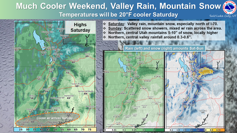
Today, a winter weather advisory goes into effect this morning at 6AM. A cold front will cross northern Utah this morning into early afternoon, and this will bring strong winds and heavy snowfall. Temperatures will be in the mid 40s. Winds will stay elevated throughout the day, with peak gusts this morning up to 55 mph at upper elevations and 30 mph at mid elevations. Snowfall totals today should be between 3-5" before 6PM this evening.
The strongest snowfall of the day will come late morning into the early afternoon. The storm totals could bring us 3-7 inches of snow, and up to .80” inches of water by tomorrow evening.
Weather story from the National Weather Service - Find full Winter Weather Advisory HERE.
Recent Avalanches
Only minimal avalanche activity was reported from Friday, including minor wet-loose activity.

Our Week in Review - where we highlight significant snow and avalanche activity from this past week has been published.
Ad
Avalanche Problem #1
New Snow
Type
Location
Likelihood
Size
Description
The issue is simple today, as the snowfall intensity increases, the avalanche danger is going to increase as well. The cold front moving in this morning is predicted to have periods of very high snowfall rates, as well as overall high snowfall totals. All of this new snow is going to have a variety of excellent bed surfaces to slide on and once the snowfall begins, I expect to see shallow new snow avalanches in the backcountry today.
With the generally warm temperatures, I expect the new snow to be fairly cohesive and should break as a shallow soft slab, but, with so many supportable bed surfaces, fast running sluffs are also likely today, especially in the upper elevations. The type of avalanche will come down to how quickly the new snow bonds, versus how quickly the snow is falling from the sky. Watch for signs of instability such as cracking and sluffing. Even a small slide can have serious consequences in big, steep terrain or if you’re above cliffs.
Today, the sensitivity of the new snow largely depends on the rate of snowfall. During higher rates of snowfall (greater than 1 inch per hour) avalanches will be easier to trigger. Pay attention to changing weather and increased snowfall rates.
Avalanche Problem #2
Wind Drifted Snow
Type
Location
Likelihood
Size
Description
This morning the winds are cranking, with gusts near 50 mph. These high southwesterly winds may create fresh wind drifts on any aspect at the mid and upper elevations. These wind drifts will be generally shallow and isolated to terrain features that allow for drifting new snow to accumulate, such as ridges, sub-ridges and gullies.
Look for obvious signs of wind-drifted snow, such as pillow-shaped slopes, cracking and whumpfing, and avoid those slopes.
Additional Information
General Announcements
Please visit this website with information about Responsible Winter Recreation by the Utah Office of Outdoor Recreation.

This information does not apply to developed ski areas or highways where avalanche control is normally done. This forecast is from the U.S.D.A. Forest Service, which is solely responsible for its content. This forecast describes general avalanche conditions and local variations always occur.