Forecast for the Abajos Area Mountains

Issued by Chris Benson on
Wednesday morning, February 3, 2021
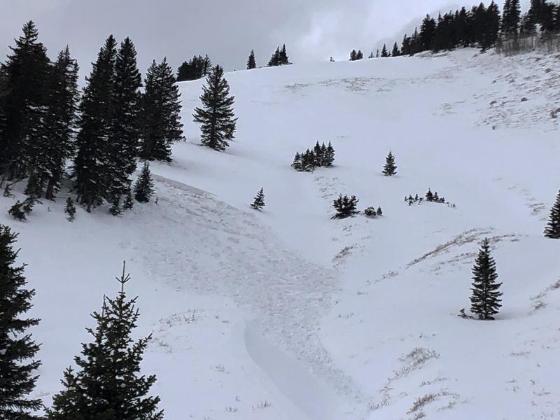
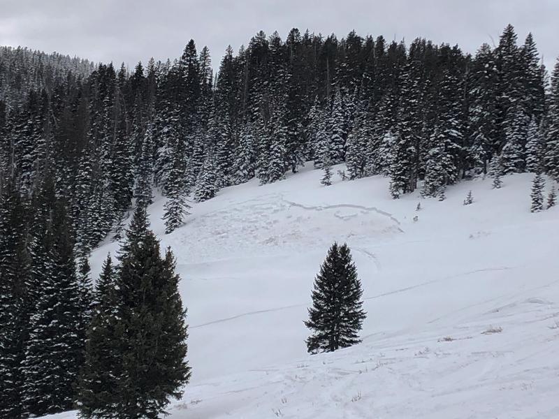
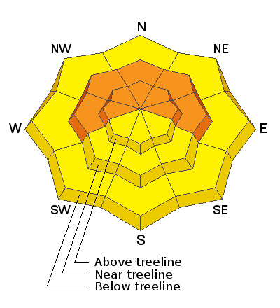
The avalanche danger is CONSIDERABLE on steep slopes facing W-N-E near and above treeline, and deep and dangerous human triggered avalanches are likely in these areas. Cautious route-finding and conservative decision-making are essential. Although it is becoming more difficult to trigger an avalanche, recent tragic events in the region highlight our precarious and unpredictable snowpack. Avalanches can be triggered from a distance and break wider and farther than expected. Elsewhere the danger is MODERATE. Warm temperatures and light overnight freezes over the last two days also warrant caution, as the "avalanche dragon" gets grumpy when things don't freeze. Stay away from slopes that display signs of warming such as roller-balls and punchy, moist snow.
Low
Moderate
Considerable
High
Extreme
Learn how to read the forecast here
Special Announcements
The Colorado Avalanche Information Center reports that three skiers are still missing after a large avalanche in the San Juan Mountains. You can read the preliminary report HERE. Additionally, the final report from a fatal accident on Saturday near the Park City Ridgeline can be read HERE. Our thoughts go out to those affected by this tragic accident, especially the family and friends of the victims.
Weather and Snow
24 Hour Snow 0" 72 Hour Snow 0" Wind SSW 20 G40 Temp 31F
Yesterday, southerly winds ranged from 15-20 mph at ridgetop. An overcast cloud layer at about 10,000' obscured the mountains for much of the day. With intermittent clear skies and these clouds acting like a blanket, we had yet another warm day temps reaching 37 F yesterday at 10,000'. Temperatures have been hovering near freezing overnight. Today, expect broken skies followed by increasing clouds and lowering ceilings throughout the day. High temperatures in the mid 30s and steady southwesterly winds 30-40 mph with gusts up to 50 mph before shifting to the northwest and dying down. Currently, there isn't much snow available for transport so not expecting wind slabs to form. The approaching storm will start warm, with a mix of rain/snow with snow starting at around 8,000'. Thunder-snow is a possiblity. While scattered storms may occur throuought the day, the main pulse will arrive this evening with an expected 1-3" from this system.
Snow totals at Buckboard Flat (8924')
Snow totals at Camp Jackson (8858')
Snowpack Discussion
It has been 4 days since our last loading event, which added much needed snow to our thin, weak, and meager snowpack. Warm temperatures over the last two days have helped the recent snow settle and adjust to the significant snow totals from last week. At sunny, lower elevation areas, reports of roller-balls and moist snow confirm that some wet-loose activity probably occured yesterday. Without a solid overnight-freeze, much of the snowpack remains in a weakend state from warm daytime temperatures. On more northerly aspects at higher elevations, dangerous slabs 2'-3' deep are perched above the weak underlying snowpack, and conditions are primed for deep and dangerous human triggered avalanches.
Recent Avalanches
Large, destructive and deadly avalanches continue to be reported from adjacent zones. On Monday, a large avalanche on a NE aspect at 11,500' caught and carried four skiers, three of which are still missing. Yesterday, a near miss occured on the Skyline at 10,000' on a north-aspect. Both of these events highlight that persistant slab avalanches are sensitive to triggering, and may break wider and farther than you might expect.
On Friday (1/29/2021), several slab avalanches were observed that failed on weak, sugary snow near the ground on steep, NE aspects. One near North Creek Pass is reported to be snowmobile triggered. Recent avalanches are clear signs of instability.
Mathew Cozart reported observing several avalanches on Sunday (1/31/21). Read his report here.
Additional Information
Information on outdoor recreation - The State of Utah created this webpage with information about recreating on both state and federal public lands during the current health crisis.

New to the backcountry (including riding at closed resorts) - Watch the award-winning, 15 minute Know Before You Go video, or take the 5-part, free online-learning series.
General Announcements
This forecast is from the U.S. Forest Service, which is solely responsible for its content. This forecast describes general avalanche conditions and local variations always occur.