Observation Date
3/30/2020
Observer Name
Derek DeBruin
Region
Ogden » Snowbasin
Location Name or Route
Ogden, Snowbasin Periphery, Porky's/Surprise
Comments
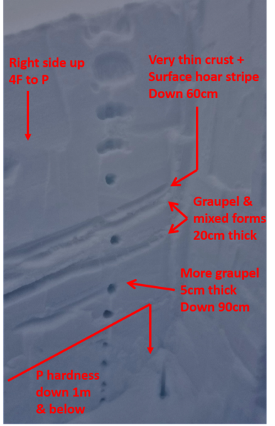
Went looking for the buried thin crust and surface hoar combination referenced in the recent No Name avalanche and found it. Dug on a 24 degree NE facing slope at 8600ft just north of the Needles and east of Porky's (near the Surprise run and the Porcupine lift, but outside the resort boundary). Found a 20cm thick pile of graupel mixed in 60cm below the surface. Sitting atop this was a very thin crust next to a stripe of barely visible surface hoar, feathers just poking out upon close examination. About 10cm below this was another 5cm layer of graupel. 1m down and below was a thick, contiguous mass of P hardness snow. See annotated photo below. Despite the structural evidence, there were no obvious shovel tilts/shears at the crust/surface hoar layer, things mostly preferring to break about 15cm down at a density change in the new snow. This density change yielded CT14 and ECTN17 15cm down (again NOT on the layer that avalanched on Friday, 20200327).
Spooky, and an indication that this particular problem may be more widespread, at least in the Mount Ogden/Snowbasin zone.

For those planning to get out at Snowbasin and hoping to minimize their exposure to avalanche hazard such as the one described above, the permitted uphill route utilized when the resort is operating is a good option that minimizes exposure to avalanche hazard. This assumes that you take the traverses and do not go directly up Sweet Revenge, and also that you take the same route down.
Today's Observed Danger Rating
Moderate
Tomorrows Estimated Danger Rating
Moderate
Coordinates


