Brett Kobernik from the Manti-Skyline will be over paying a visit, and he'll be handling the forecast for the next couple of days while I'm over in the San Juans. Thanks Brett!
The UAC's Avy Awareness Auction is currently underway with tons of great gear, jewelry, artwork and experiences available.
Visit the auction page here to help support the UAC's spring avalanche awareness and outreach efforts.
A new version of the UAC IOS application is
now available on the Apple App Store. This version fixes many of the issues that occur when running IOS 13.
Road Conditions: The most recent snow has been well packed in by traffic. The road is slick and icy in places.
Grooming report: LUNA (Lower Utah Nordic Alliance) groomed all trails on Monday. Thanks Matt!
24 Hour Snow 0" Weekly Snow 2" Base Depth in Gold Basin 48" Wind N 15 mph G25 Temp 4F
Weather: NW winds finally backed off a bit around midnight last night after cranking most of the day yesterday in the 25-30 mph range with frequent gusts into the 40's. It looks like they're going to be back at it again today though slightly more northeasterly. Skies will be mostly sunny and high temps will be in the mid-teens. With that cold north wind a blowin, it's going to be downright frigid up there. We should start to get a break from the wind late tonight. Sunny skies and gradually warming temperatures are on tap through Saturday.
Snowpack: The weekend storm brought a disappointing 2" of new snow to the mountains. It was nevertheless nice to see a fresh coat of white on things and the new snow did make for a decent refresh, especially in sheltered areas where the underlying snow was soft and recrystallized. Unfortunately, yesterday's winds wreaked havoc on exposed terrain so sticking to sheltered areas below treeline will be your best bet for finding decent conditions.
Over the past several weeks, the snowpack has been transforming into a pile of loose, sugary, facets and the underlying structure is at its weakest point of the season. The most recent snow hasn't added much of a load but recent wind drifts may still be sensitive wherever they exist on top of loose, weak, recrystallized snow. With an eye to the future, the snowpack is in very poor shape to withstand a significant load, so expect a dramatic change in avalanche conditions if and when a new snow load finally comes.
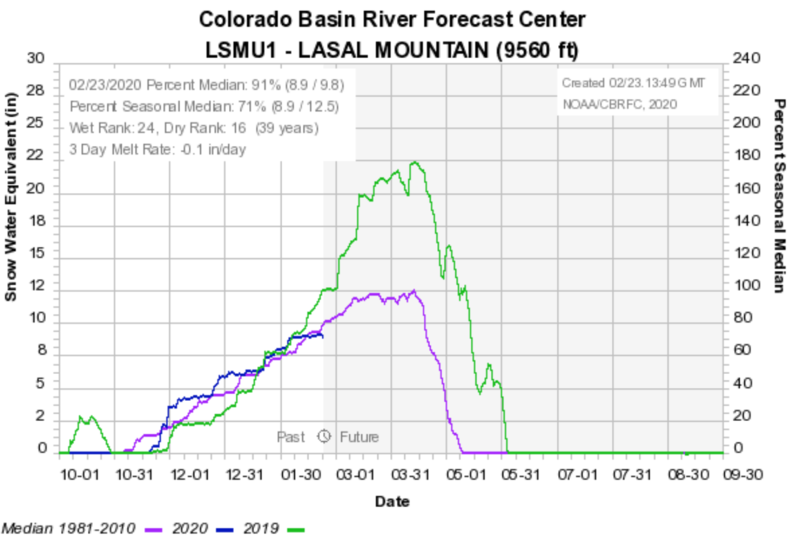
Remarkably, we've only just dipped below the median snowpack average and are still hanging in there at 91%.
The SE Utah region is still over 100%.