Forecast for the Moab Area Mountains

Eric Trenbeath
Issued by Eric Trenbeath on
Friday morning, February 7, 2020
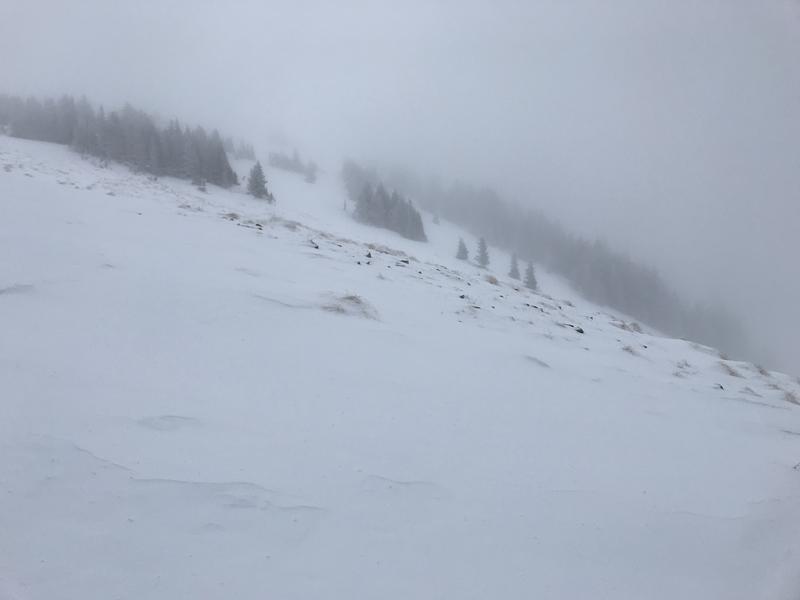
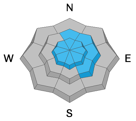
The avalanche danger remains MODERATE today and human triggered avalanches involving wind drifted snow are possible. The danger is greatest on upper elevation slopes facing N-NE-SE, but strong and shifting winds have deposited drifts on all aspects. Drifts can be found adjacent to wind-scoured terrain, with subtle terrain features making all the difference. Drifts may also be found farther downslope than usual. Wind drifts are recognizable by their smooth, rounded appearance and cracking is a sign of instability. In areas where the underlying snow is shallow and weak, a triggered wind drift may cause a deeper and more dangerous avalanche. Choose terrain carefully and avoid steep slopes with recent deposits of wind drifted snow.
Low
Moderate
Considerable
High
Extreme
Learn how to read the forecast here
Special Announcements
Are you looking to improve your avalanche skills? We are offering a Backcountry 101: Introduction to Avalanches class on February 15-16 in Moab. Click here to register A huge thanks to Moab Gear Trader for sponsoring this course. Please visit them for all your winter backcountry needs.
Road Conditions: Grand County has plowed and widened the road. A big thanks to them for keeping access open this winter!
Grooming report: Matt from LUNA (Lower Utah Nordic Alliance) groomed on Wednesday. Thanks Matt!
Weather and Snow
24 Hour Snow T" Weekly Snow 10" Base Depth in Gold Basin 50" Wind NW 15 G 25 mph Temp 22F
Weather: After blowing in the 20-30 mph range with gusts into the 40's for most of the day yesterday, NW winds started backing off around midnight last night. Low clouds are hanging over the mountains this morning but we should see partly sunny skies later today. NW ridge top winds will be moderate, with high temps in the upper 20's. An active weather pattern is bringing heavy snowfall to northern Utah and north-central Colorado but unfortunately, we are being left high and dry. The next cold front will drop down from the NW Saturday evening bringing us a chance for snow on Sunday.
Snowpack: Strong and shifting winds over the past several days have worked over the snow surface in exposed terrain leading to what observer Nate Ament described as "a complex patchwork of variable snow surfaces and wind deposits on multiple aspects." Read Nate's observation here. Need I say more? For best snow conditions to wind sheltered terrain below treeline.
Underneath the surface, the snowpack is taking the form of a mid-season continental snowpack on an average year, with varying depths and strengths minus the depth hoar. In most areas above about 10,500', the pack is deep and strong with a depth of 4'-5'. But sun and wind-exposed slopes, and rocky areas right around treeline and below have shallower and weaker snow. In most cases, these weaker snow areas are not yet a problem. Isolated concerns exist in areas of steep, rocky, or sparsely wooded extreme terrain where wind drifted snow has been added to the underlying weak snow.
Wind, temperature, humidity on Pre Laurel Peak (11,700')
Storm totals at Gold Basin Study Plot (10,000').
Snotel site near Geyser Pass Trailhead (9600').
NWS weather forecast
It was a day for the intrepid out there yesterday. Nate Ament photo.
Recent Avalanches
Our repeat running favorite in Tele Gold pulled out again sometime during the storm. For details see this report from Brian Hays.
Ad
Avalanche Problem #1
Wind Drifted Snow
Type
Location
Likelihood
Size
Description
Human triggered avalanches involving recent deposits of wind drifted snow continue to be your primary concern today. Though your greatest concern continues to be on steep, wind loaded slopes that have N-E-SE aspects, Strong and shifting winds over the past days have deposited drifts on all sides of the compass. Deep drifts can be found adjacent to wind-scoured terrain, with subtle terrain features making all the difference. Drifts may also be found farther downslope than usual. Wind drifts are recognizable by their smooth, rounded appearance and cracking is a sign of instability. Choose terrain carefully and avoid steep slopes with recent deposits of wind drifted snow.
Avalanche Problem #2
Persistent Weak Layer
Type
Location
Likelihood
Size
Description
We've been seeing some cracks develop in our generally strong snowpack, particularly in our mid-elevation band just below treeline. In these areas, the snowpack is shallower, between 3'-4' deep, and layers of weak faceted snow are beginning to develop. This storm, with an inch of water weight, is the second incremental test of these buried weak layers. Add drifting and the load may be significant enough for a skier or rider to trigger a deeper and more dangerous avalanche in areas of more extreme terrain. Avoid steep, wind drifted slopes, especially in areas where you suspect the underlying snowpack is shallow and weak.
We've also been tracking a reactive weak layer on SE facing slopes. I hoped the warm temps over last weekend would have put an end to this concern, but I'm still getting reports of collapsing where wind deposited snow has added stress to this buried weak layer.
General Announcements
My radio interview on KZMU about the history of backcountry skiing in the La Sals, avalanche accidents, and unique snowpack has been saved in perpetuity. You can listen to it here.
Check out the avalanche beacon training park at the Geyser Pass Trailhead and practice your rescue skills!
This forecast is from the U.S. Forest Service, which is solely responsible for its content. This forecast describes general avalanche conditions and local variations always occur.