Forecast for the Abajos Area Mountains

Eric Trenbeath
Issued by Eric Trenbeath on
Monday morning, February 3, 2020
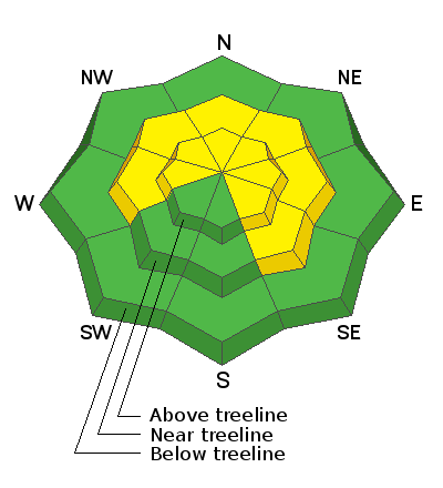
Expect a rising avalanche danger today. Strong southerly winds are blowing and drifting snow and the danger is MODERATE on steep, wind drifted slopes that face W-N-SE. Human triggered avalanches are possible in these areas and the danger will become more widespread throughout the day. Fresh drifts are often recognizable by their smooth, rounded appearance and cracking is a sign of instability. Be alert to changing conditions and avoid steep slopes with recent deposits of wind drifted snow.
Low
Moderate
Considerable
High
Extreme
Learn how to read the forecast here
Special Announcements
Are you looking to improve your avalanche skills? We are offering a Backcountry 101: Introduction to Avalanches class on February 15-16 in Moab. Click here to register. A huge thanks to Moab Gear Trader for sponsoring this course. Please visit them for all your winter backcountry needs.
New UAC Podcast: The Art of Storytelling Through Film - A Conversation with Trent Meisenheimer check it out HERE.
Weather and Snow
Weather: Winds are nuking! Since about midnight they have blown in the 40-45 mph range with gusts to 70 mph. The front has yet to arrive on this storm, expect passage sometime this morning. Though we could see periods of heavy snowfall, overall totals look to be fairly meager with only 2"-4" possible. But at least it will be windy! Today may be a good day to get a jump on some of those spring cleaning projects like sorting the sock drawer. Winds will taper off slightly during the day with a chance of snow lingering through tonight. High temps will be in the mid to upper 20's. Cold air will fill in behind the storm with lows tonight dropping to around zero. Cold air will remain through Wednesday, with high temps on Tuesday of around 1o degrees.
Snowpack: It's a mixed bag out there right now and strong winds will further erode the snow surface. Nevertheless, good snow can still be found. Kevin Dressel was up yesterday and reported finding good settled powder conditions in the trees on northerly aspects.
Underneath, the snowpack is also variable. In many areas above about 9500' the pack is deep and strong with a depth of 4'-5'. But sun and wind-exposed slopes, and steep rocky areas have shallower and weaker snow. Whether or not these weaker snowpack areas become unstable will depend on future snow loads.
Snow totals at Buckboard Flat (8924')
Snow totals at Camp Jackson (8858')
Recent Avalanches
General Announcements
This forecast is from the U.S. Forest Service, which is solely responsible for its content. This forecast describes general avalanche conditions and local variations always occur.