Forecast for the Moab Area Mountains

Eric Trenbeath
Issued by Eric Trenbeath on
Friday morning, January 31, 2020
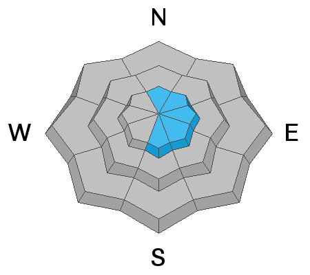
Northerly winds continue to blow and drift snow, and the avalanche danger remains MODERATE on all aspects at upper elevations. Look for recent deposits of wind drifted snow on the leeward sides of ridge crests and terrain features including sub-ridges, rock outcroppings, and gully walls. To avoid wind slabs, and to find the best snow, stick to mid and lower elevation, wind-sheltered terrain where the avalanche danger is generally LOW. There is also a MODERATE danger for triggering an avalanche on a buried persistent weak layer, particularly on wind loaded slopes that face S-SE. Other outlying areas of concern include steep, rocky, northerly facing terrain that has a shallow snowpack.
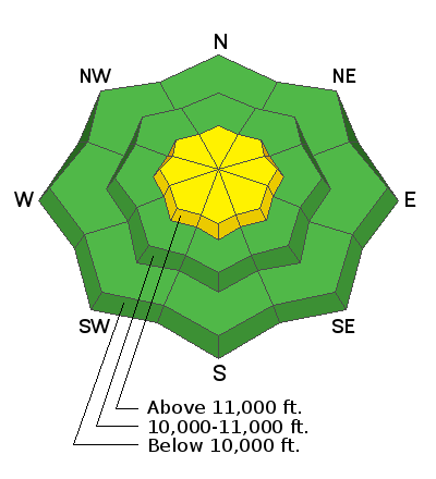
Low
Moderate
Considerable
High
Extreme
Learn how to read the forecast here
Special Announcements
Are you looking to improve your avalanche skills? We are offering a Backcountry 101: Introduction to Avalanches class on February 15-16 in Moab. Click here to register A huge thanks to Moab Gear Trader for sponsoring this course. Please visit them for all your winter backcountry needs.
New UAC Podcast: The Art of Storytelling Through Film - A Conversation with Trent Meisenheimer check it out HERE.
Road Conditions: Grand County plowed on Tuesday. The road is clear but snowpacked.
Grooming report: LUNA's (Lower Utah Nordic Alliance) dedicated groomer Matt Hebberd will be up grooming today insuring good conditions for the weekend.
Weather and Snow
24 Hour Snow 0" Weekly Snow 5" Base Depth in Gold Basin 50" Wind N 18 G30 mph Temp 13F
Weather: Northerly winds over the past 24 hours have blown in the 15-20 mph range with gusts into the 30's, and it looks like that trend will continue today. Skies will be sunny with high temps in the upper 20's. Dry conditions will remain through the weekend with a promising looking storm moving into the region on Monday.
Snow conditions: Sun and winds are taking a toll on the snow surface. Northerly winds are particularly bad for snow conditions since we seek northerly aspects for the best snow. Most open, exposed, north-facing terrain will bare the signs of wind damage, and most south-facing terrain will be sun crusted. You will have to seek sheltered terrain below treeline to find good snow today. Underneath, the snowpack is also variable. In many areas above about 10,500; the pack is deep and strong. Wind exposed slopes, and rocky areas right around treeline and below have shallower and weaker snow.
Wind, temperature, humidity on Pre Laurel Peak (11,700')
Storm totals at Gold Basin Study Plot (10,000').
Snotel site near Geyser Pass Trailhead (9600').
NWS weather forecast
Ad
Avalanche Problem #1
Wind Drifted Snow
Type
Location
Likelihood
Size
Description
Winds continue to blow and drift snow and new wind slabs may be found on all aspects at upper elevations. Slabs may be new and soft, or old and hard, often existing next to wind-scoured or wind-sculpted surfaces. Look for areas of drifted snow on the leeward sides of ridge crests and terrain features including sub-ridges, rock outcroppings, and gully walls. Suspect areas that have a hollow sound or feel to them and cracking is a sign of instability. To avoid wind slabs, and to find the best snow, stick to mid and lower elevation, wind sheltered terrain.
Avalanche Problem #2
Persistent Weak Layer
Type
Location
Likelihood
Size
Description
Spatial variability in the snowpack is the key phrase right now. Many areas have a deep and strong, underlying snowpack, while wind exposed areas, and rocky slopes right around treeline and below have a shallower and weaker snowpack. A prominent, and still reactive weak layer exists on SE-S facing slopes, and when wind-loaded, this layer will be reactive to the weight of a skier or rider. To avoid slopes that have a weak layer, stick to more sheltered terrain below ridge crests, and on slopes that have a deep, underlying snowpack.
General Announcements
My radio interview on KZMU about the history of backcountry skiing in the La Sals, avalanche accidents, and unique snowpack has been saved in perpetuity. You can listen to it here.
Check out the avalanche beacon training park at the Geyser Pass Trailhead and practice your rescue skills!
This forecast is from the U.S. Forest Service, which is solely responsible for its content. This forecast describes general avalanche conditions and local variations always occur.