Forecast for the Moab Area Mountains

Eric Trenbeath
Issued by Eric Trenbeath on
Tuesday morning, January 28, 2020
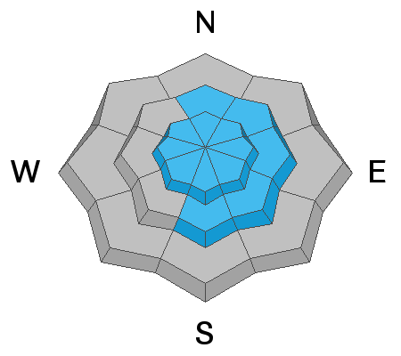
Unstable areas of wind drifted snow continue to be our primary concern and the avalanche danger is MODERATE. Steep, wind drifted slopes right around treeline and above that face N-NE-SE are the most likely areas for you to trigger an avalanche but unstable drifts may be found on all aspects at upper elevations. A triggered wind slab also has the potential to break into a buried persistent weak layer causing a deeper, and more dangerous avalanche. Areas of steep, rocky, more radical terrain are where you are most likely to find this problem. Slope by slope analysis is important at this time.
Low
Moderate
Considerable
High
Extreme
Learn how to read the forecast here
Special Announcements
Are you looking to improve your avalanche skills? We are offering a Backcountry 101: Introduction to Avalanches class on February 15-16 in Moab. Click here to register A huge thanks to Moab Gear Trader for sponsoring this course. Please visit them for all your winter backcountry needs.
New UAC Podcast: The Art of Storytelling Through Film - A Conversation with Trent Meisenheimer check it out HERE.
Road Conditions: Grand County will be plowing this morning. The gate will be closed while plowing is in progress.
Grooming report: Matt will be up grooming the lower mountain today.
Weather and Snow
24 Hour Snow 3" Weekly Snow 14" Base Depth in Gold Basin 46" Wind NW 15-25 mph Temp 6F
Weather: The mountains picked up 3" of new snow from yesterday's quick hitting system with maybe as much as 5" up high. Unfortunately, we may be a little hard pressed to find it today as NW winds have blown solidly for the past 24 hours in the 15-20 mph range with gusts to near 30. Today look for mostly sunny skies in the mountains this morning and hopefully, dissipating fog in the valleys. Northerly winds will blow in the 10-15 mph range, and high temps will rise to the mid and upper 20's. We should see increasing clouds today ahead of a weak system that will take a dive far to the south of us. Dry conditions are on tap for the rest of the week and into the weekend.
Snow conditions: The snowpack has seen it all over the past week starting with around 10" of snow last Wednesday. Sustained, moderate NW winds alternately drifted snow and scoured surfaces, while periods of sun and warm temperatures crusted over southerly aspects. Soft snow remains in sheltered locations and the most recent snow should provide a refresh in those same areas. Underneath, the snowpack is also variable. In many areas above about 10,500; the pack is deep and strong. Wind exposed slopes, and rocky areas right around treeline and below have shallower and weaker snow.
Wind, temperature, humidity on Pre Laurel Peak (11,700')
Storm totals at Gold Basin Study Plot (10,000').
Snotel site near Geyser Pass Trailhead (9600').
NWS weather forecast
Recent Avalanches
More reports of natural activity from last week's snow and wind event continue to trickle in. Chris Benson sent in this report of a natural avalanche he observed in Dark Canyon.
Jonathan Dutrow from Talking Mountain Yurts reported a wind slab avalanche on a SE aspect near Burro Pass.
Other slides detailed earlier:
Storm snow avalanche in Talking Mountain Cirque on the night of Wed 21.
Wind slab release from a repeat running path in Tele Gold that also likely ran sometime the night of Wednesday, Jan 21.
Wind slab avalanche from the night of January, 22.
Ad
Avalanche Problem #1
Wind Drifted Snow
Type
Location
Likelihood
Size
Description
Potentially unstable areas of wind drifted snow continue to be our primary concern. The most likely areas for you to encounter unstable wind slabs are on steep slopes facing N-E-SE right around treeline and above but drifting may exist on all aspects at upper elevations. In some cases, recent drifts may exist adjacent to scoured snow surfaces. Suspect smooth rounded pillows, or hollow feeling areas and avoid steep, convex slopes with blind breakovers that lure you beyond the point of no return.
Avalanche Problem #2
Persistent Weak Layer
Type
Location
Likelihood
Size
Description
Spatial variability in the snowpack is the key phrase right now. Many areas have a deep and strong, underlying snowpack, while wind exposed areas, and rocky slopes right around treeline and below have a shallower and weaker snowpack. In addition, I have observed a reactive, persistent weak layer on S-SE facing slopes. It's now been close to a week since the last significant load has been added to the snowpack and I don't have a great feel for how reactive these layers are at this point. We'll be out and about today trying to get a handle on this. Regardless, the problem isn't widespread, but it does exist on isolated terrain features on many aspects. Approach steep terrain with this in mind, particularly in areas of rocky, more radical terrain.
General Announcements
My radio interview on KZMU about the history of backcountry skiing in the La Sals, avalanche accidents, and unique snowpack has been saved in perpetuity. You can listen to it here.
Check out the avalanche beacon training park at the Geyser Pass Trailhead and practice your rescue skills!
This forecast is from the U.S. Forest Service, which is solely responsible for its content. This forecast describes general avalanche conditions and local variations always occur.