Forecast for the Skyline Area Mountains

Brett Kobernik
Issued by Brett Kobernik on
Friday morning, January 24, 2020
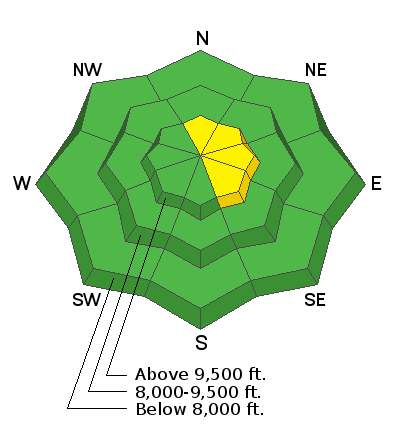
The avalanche danger remains generally LOW. A spotty MODERATE danger exists along the upper east facing ridges where a person could trigger a wind drift or cornice.
Low
Moderate
Considerable
High
Extreme
Learn how to read the forecast here
Weather and Snow
Current Conditions: Temperatures cooled off overnight and are around 20 at most mountain locations. The wind has slowed as well and is generally light from the west. You'll find dense creamy snow on the surface in many locations.
Mountain Weather: A ridge of high pressure dominates our weather pattern through the weekend. We'll see ridgetop highs around 30. A weak storm attempts to bust through later today but won't do much more than produce a few snow flurries. Saturday looks like a nice day with partly cloudy skies. There will be a few more clouds on Sunday and another small storm shaping up for Sunday night which might bring a few inches of snow.
Ad
Avalanche Problem #1
Normal Caution
Type
Location
Likelihood
Size
Description
It's pretty quiet out there right now. There's really not a lot to talk about as avalanche conditions go. Here are a few things to consider.
  • Continue to use caution on the steepest more east facing slopes where recently formed drifts and cornices are present.
  • Only put one rider at a time on steep slopes.
  • Don't regroup at the bottom of steep slopes where avalanche debris can pile up.
  • Be sure everyone has the proper avalanche rescue gear and knows how to use it.
Additional Information
This forecast is from the U.S. Forest Service, which is solely responsible for its content. This forecast describes general avalanche conditions and local variations always occur.