Forecast for the Provo Area Mountains

Drew Hardesty
Issued by Drew Hardesty on
Tuesday morning, January 7, 2020
A MODERATE danger exists for human triggered avalanches 8-16" deep on all aspects of the upper elevations. The MODERATE danger extends down to the mid-elevations on east to south to west facing aspects. Conditions are unusual and tricky on these sunny aspects.
Loose wet snow avalanches may be possible on the steepest sunlit slopes with daytime heating.
Low
Moderate
Considerable
High
Extreme
Learn how to read the forecast here
Special Announcements
Get discount lift tickets HERE. Thanks for this generous support from Utah Ski Resorts and Ski Utah. All proceeds go directly to supporting the UAC.
New to the backcountry or in need of a refresher? Consider taking a companion rescue course offered at Woodward Park City, January 14, 5:30-9 p.m.
Weather and Snow
Skies are partly cloudy with generally light westerly winds. Mountain temps are in the upper 20s. Ahead of tomorrow's weak storm (perhaps 2-4" expected), we'll see increasing high clouds, strengthening backing winds to the southwest, and temps warming to the mid to upper 30s. The long range models suggest a progressive and active weather pattern for the next 7-10 days.
Recent Avalanches
None reported from the backcountry yesterday.
Ad
Avalanche Problem #1
Persistent Weak Layer
Type
Location
Likelihood
Size
Description
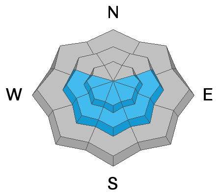
A poor and unstable snow structure exists in variable terrain on east to south to some westerly facing aspects at the mid and upper elevations. Persistent weak layers of faceted grains exist adjacent to a melt-freeze crust now buried 8-16" deep beneath the settled storm snow since New Year's. This unusually active structure on the sunny aspects is responsible for at least a dozen avalanches with a number of very close calls in the central Wasatch.
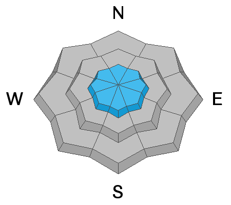
The bad news: this structure is likely to continue to catch people off guard as it is more common to have active Persistent Weak Layers on the northerly aspects. Collapsing and cracking of this layering is less evident than before and the danger may be less obvious.
The good news: on northerly aspects, we can get lured into the danger because the skiing and riding conditions are so good. Currently the northerly aspects with the good snow are generally safe with some isolated exceptions (see below). The sunny aspects with the danger now also host poor riding conditions.
A great deal of uncertainty exists with this issue. This structure, while most prominent on southeast to southwest facing aspects, is variable and inconsistent from canyon to canyon and perhaps slope to slope. *Mark and Trent have an excellent observation from upper Snake Creek yesterday addressing this issue and how to look for this problem HERE. Bo Torrey talks about the uncertainty with this unusual pattern HERE. I plan to avoid these areas that host these crusts (and poor skiing/riding) and instead recreate on non-wind drifted northerly terrain for now.
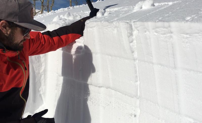
Photo of Trent looking at crusts (pcStaples)
Avalanche Problem #2
Wind Drifted Snow
Type
Location
Likelihood
Size
Description
A secondary concern revolves around lingering remnant generally hard wind drifts from the strong and veering southwest to northwest winds over the past 48 hours. If you're looking for them, they'll be most likely found in the highest elevations and exposed terrain (cross-loaded in Great NW cirque of Box Elder anyone?).
IF the southwest winds pick up earlier than expected, watch for new wind drifts in steep lee terrain.
Additional Information
A call for observations: if you are getting out in the backcountry of the Provo mountains, please let us know what you're seeing. You don't need to be an avalanche professional to report bull's eye conditions such as avalanches, cracking, collapsing or simply snow conditions.
General Announcements
This information does not apply to developed ski areas or highways where avalanche control is normally done. This forecast is from the U.S.D.A. Forest Service, which is solely responsible for its content. This forecast describes general avalanche conditions and local variations always occur.