Forecast for the Abajos Area Mountains

Issued by Eric Trenbeath on
Sunday morning, January 5, 2020
Sunday morning, January 5, 2020
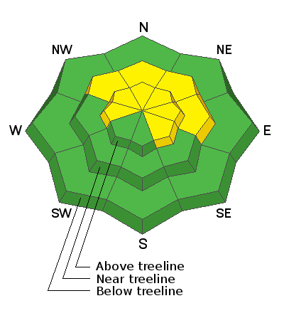
The avalanche danger is MODERATE and human triggered avalanches remain possible on steep, wind drifted slopes that have primarily a NW-N-E aspect. Some drifting and cross-loading may also exist on W and SE facing slopes. A triggered wind slab also has the potential to step down into a buried, persistent weak layer causing a deeper and more dangerous avalanche. You are most likely to encounter a persistent weak layer on steep, shady, northerly facing slopes. Most low elevation and south-facing terrain have LOW danger.

Low
Moderate
Considerable
High
Extreme
Learn how to read the forecast here
 Special Announcements
Grooming: The Hart's Draw road has been recently groomed to 70's Flat.
 Weather and Snow
The story for the past several days has been the wind. Yesterday, SW winds averaged 20-30 mph along ridge crests with gusts into the 40's. Mid-week, we had a relatively strong N wind event. This has resulted in blowing, drifting, and scouring of snow on all aspects at upper elevations. Today we'll continue to see blustery southerly winds in the 20-30 mph range. Skies will be mostly sunny and high temps will be in the upper 20's. The crystal ball is advertising a chance for snow and a more active pattern kicking in late this week.
Snow totals at Buckboard Flat (8924')
Snow totals at Camp Jackson (8858')
Wind, temperature, and humidity on Abajo Peak (11,000')
 Recent Avalanches
General Announcements
This forecast is from the U.S. Forest Service, which is solely responsible for its content. This forecast describes general avalanche conditions and local variations always occur.


