Forecast for the Provo Area Mountains

Trent Meisenheimer
Issued by Trent Meisenheimer on
Saturday morning, November 30, 2019
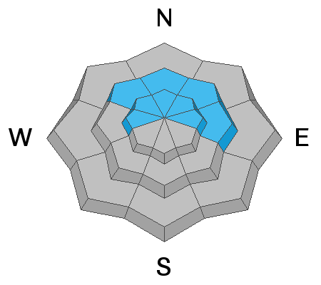
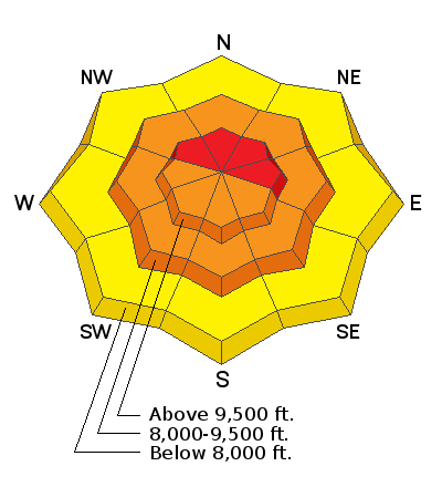
Today, the avalanche danger is HIGH on upper elevation slopes that face northwest through east for triggering an avalanche into old weak snow. Continued snow and winds mean natural avalanches are possible, and human-triggered avalanches are likely in steep wind drifted terrain. Mid-elevation slopes have a CONSIDERABLE hazard. Slopes at low elevations didn't have that weak faceted basal layer or much a snowpack at all before this storm, thus they have a MODERATE danger. Travel in avalanche terrain is not recommended.

What to do? The only viable strategy is to ride low angle slopes (less than 30 degrees in steepness) which are not steep enough for an avalanche and avoid being underneath steep slopes.
Low
Moderate
Considerable
High
Extreme
Learn how to read the forecast here
Avalanche Warning
IN EFFECT FROM 6 AM MST THIS MORNING TO 6 AM MST SUNDAY
FOR THE CENTRAL AND SOUTHERN WASATCH RANGE, INCLUDING THE WESTERN UINTAS.
THE AVALANCHE DANGER TODAY IS HIGH.
VERY DANGEROUS AVALANCHE CONDITIONS EXIST. HUMAN TRIGGERED AND NATURAL AVALANCHES ARE LIKELY. STAY OFF OF AND OUT FROM UNDER SLOPES STEEPER THAN 30 DEGREES. AVALANCHES MAY BE TRIGGERED FROM A DISTANCE OR FROM BENEATH STEEP SLOPES.
Special Announcements
The First Annual Statewide Avalanche Awareness Week is December 2-7. We have a week full of fun and educational events planned. Check out the schedule here.
Drew Hardesty released the first UAC podcast of the season " Early Season Essentials with Program Director Bo Torrey" check it out HERE.
Weather and Snow
Yesterday's cold front came in around noon shifting the winds to the northwest, dropping the temperatures and bringing snow to the valley floor. In the past 24 hrs the Provo area has picked up another 4-6" of new snow with 0.26" of water. Overnight and into this morning the westerly winds continue to blow at speeds of 5-15 mph gusting into the 20's at upper elevations. Temperatures plummeted yesterday afternoon and are now sitting in the teens °F.
As the storm exits to our east we will remain under a cold west-north-west flow and the northerly winds are expected to continue into the late afternoon with speeds of 10-15 mph gusting into the 30's. We should see another 2-5" of new snow this morning into the afternoon before tapering off later this evening.

What a week of weather!!! Storm snow totals since Monday the 25th are trickling in and it's impressive:
Provo Mountains: 24-33" snow (1.75 - 2.5" h20)
Wasatch Mountains: 50-70" snow (3.5 - 4.34" h20)
Park City Ridgline: 30-40" snow (2.5 - 3.0" h20)
Ogden Mountains: 40-50" snow (4.0 - 4.8" h20)
Recent Avalanches
There were no new observations from the Provo area. However, our neighbors to the north have been very active. Overnight Thursday the central Wasatch mountains went through a natural avalanche cycle with avalanches extending up to 1.5 miles wide on the northerly aspects. Yesterday, we had reports of widespread natural and human triggered activity in the backcountry on all aspects at the mid and upper elevations.
Ski areas triggered large full depth avalanches that failed on weak faceted snow found at the base of the snowpack. Veteran patrollers reported avalanches in areas they haven't seen slide in years. They also reported avalanches were being triggered from 300' feet away, running fast and far.
These avalanches were found on the northerly facing slopes and were 2-4' deep 100-300' feet wide failing at the ground on weak, sugary, faceted snow. Be sure to check out our observations page for more info on each reported slide. Found HERE.
Photo: Slab avalanche from the Days Fork ridgeline.
Ad
Avalanche Problem #1
Persistent Weak Layer
Type
Location
Likelihood
Size
Description
Dangerous and deadly slabs of snow hang in balance awaiting a trigger on aspects facing west through east at the mid and upper elevations. These avalanches are failing on a weak layer of faceted snow found at the base of the snowpack. Avalanches are 2-4' deep and hundreds of feet wide and likely unsurvivable. Avalanches can be triggered from a distance. Avoid being on, underneath, or adjacent to any steep slope.
The strategy is simple, AVOID AVALANCHE TERRAIN ALTOGETHER. There is no secret, if you head to steep northerly facing terrain you will find a deep and deadly avalanche.
Video: This is upper elevation Cottonwood ridgeline. This is why avalalnches are happening right now.
Avalanche Problem #2
Wind Drifted Snow
Type
Location
Likelihood
Size
Description
Overnight and into this morning the west-north-west winds have blown the new snow into sensitive drifts on all mid and upper elevation aspects. Expect both hard and soft slabs of wind drifted snow. Look for signs of sensitive wind drifted snow, such as shooting cracks, pillowy rounded snow, hollow sounding snow, and avoid those areas.
Avalanche Problem #3
New Snow
Type
Location
Likelihood
Size
Description
Over the past week the Provo area mountains have received 18-24" of new snow. This snow has come in many waves with a lot of different temperatures and densities. You cannot rule out new snow soft slab avalanches on all aspects at the mid and upper elevations. Use test slopes and stability tests to determine if the new snow is unstable.
General Announcements
This information does not apply to developed ski areas or highways where avalanche control is normally done. This forecast is from the U.S.D.A. Forest Service, which is solely responsible for its content. This forecast describes general avalanche conditions and local variations always occur.