Forecast for the Provo Area Mountains

Issued by Evelyn Lees on
Wednesday morning, November 20, 2019
Wednesday morning, November 20, 2019
Avalanche season is here, with shady upper elevation slopes where old snow exists in the Provo area mountains the bulls eye terrain for avalanches today. With the first few inches of snow today, expect new snow sluffs. If we get more than about 6 inches of snow, with wind, expect to trigger shallow slabs breaking on the persistent weak layer. Evaluate snow and terrain at the upper elevations carefully today.
If you get caught and go for a ride even in a small slide, hitting rocks and stumps is likely.
Low
Moderate
Considerable
High
Extreme
Learn how to read the forecast here
 Special Announcements
Remember, the open and closed resorts have different uphill travel policies, which may change daily as they work towards opening for the season. Check with each resort for the current information. Terrain in unopened resorts must be treated as backcountry.
As part of your early season tune-up, consider taking an avalanche class. We have lots of avalanche education classes listed already:
 Weather and Snow
The low pressure system over central California this morning is slowly moving into northern Utah, bringing rain and snow along with colder temperatures through Thursday evening. For today, 2 to 4 inches is expected at the mid elevations, with 5 to 7" possible at the higher elevations in the Provo area mountains by tonight. The rain/snow line is expected to remain between 7000 and 8,000' ft today and snow densities will be high.
Winds will be from the south to southeast, averaging 10 to 20 mph, with gusts in the upper 20s. Snow levels will fall a bit overnight, and winds will turn more easterly, favoring the back side of the Wasatch. High pressure will work east across the Great Basin this weekend. Next week is looking more stormy, and winter may finally be here to stay.
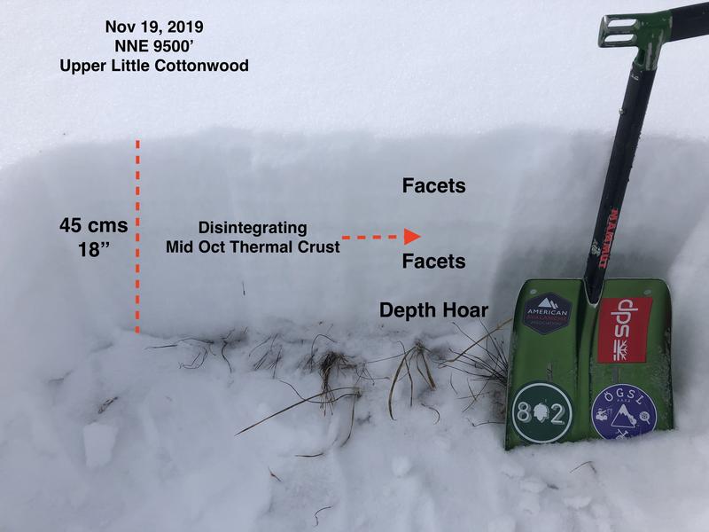
There is about 6" of snow on the shady mid elevation slopes in the Provo area mountains, and I would suspect up to a foot at the upper elevations. Old snow distribution is going to be very important the next few weeks, so be conscious of where coverage is as it forming a weak layer at the ground.
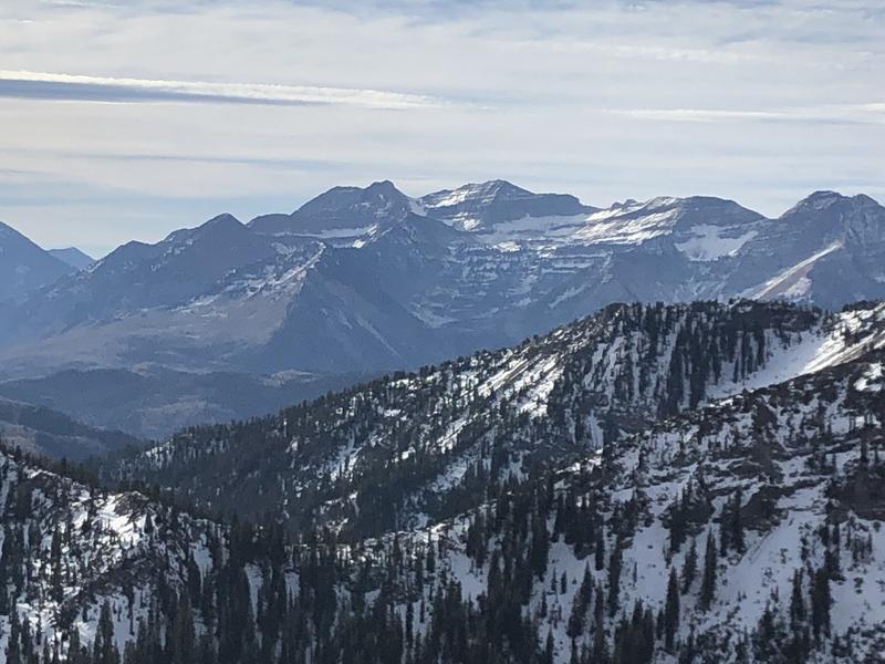
Here is a photo Greg Gagne took yesterday, with Timp in the backcountry showing old snow coverage.

Avalanche Problem #1
Persistent Weak Layer
Type
Location
Likelihood
Size
Description
Avalanche season is on our doorstep. The shady upper elevation slopes harbor enough old snow to be a problem. The old snow has weakened into a mix of sugary facets and thin crusts. As the first few inches of snow add up today, new snow sluffs will be easy to trigger, running on the crusts or the weak facets. These loose snow sluffs will run further than expected in steep terrain.
If you're in upper elevation terrain that gets more than about 6 inches of snow on top of the old, weak snow, expect to trigger very sensitive shallow slabs of snow, especially in any wind drifted areas. These slides will be breaking on the persistent weak layer of faceted snow, and can be triggered from a distance. While shallow, again, they could run much further than expected.
Here is a great photo by Greg Gagne of the old snow that was on the ground yesterday, in the Cottonwoods. It is similar to what you will find on upper elevation, shady slopes in the Provo area mountains.