AVALANCHE WARNING!! Tap for info
UDOT PLANNED AVALANCHE CLOSURES!!

Forecast for the Abajos Area Mountains

Eric Trenbeath
Issued by Eric Trenbeath on
Sunday morning, January 27, 2019
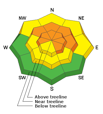
The avalanche danger is CONSIDERABLE on steep wind drifted slopes, primarily in mid and upper elevation, wind exposed terrain, that has a W-N-SE aspect. Human triggered avalanches are likely in these areas. Lower elevation, and south facing terrain offers mostly MODERATE danger.
Low
Moderate
Considerable
High
Extreme
Learn how to read the forecast here
Special Announcements
Our deepest sympathies go out to the family and friends of local Monticello resident, Scott Pehrson Jr. who was caught and buried by a fatal avalanche in the La Sals on Friday, January 25. Search and rescue teams recovered his body yesterday afternoon. Much thanks to San Juan, and Grand County Search and Rescues, Classic Air Medical, and the Utah Department of Public Safety, as well as Wasatch Powder Bird Guides, and professional dog teams from Wasatch Backcountry Rescue, Alta, and Park City ski patrols. Here is the preliminary report that will be updated with more information soon.
We will be offering a Backcountry 101 avalanche course on Feb 8, 9. It's a great way to up your avalanche knowledge with both classroom, and hands on field instruction. Click here for more details and to register.
Weather and Snow
Warmer temps and slower wind speeds are the only changed in weather this morning. Skies are clear and 10,000' temps are in the high teens, and NW winds are light blowing 5-15 mph along ridge tops. Today look for sunny skies and high temps in the upper 20's. NW winds will continue to be mostly light. There are no storms for the foreseeable future.
Soft snow conditions can still be found in sheltered locations but much of the exposed terrain has taken a hit from the wind and sun. The snowpack is complex and dangerous with buried, persistent weak layers and a liberal scattering of wind slabs. Don't let the sunny day lure you into a false sense of security. For quality and safety, stick to low angle, wind sheltered terrain.
Snow totals at Buckboard Flat (8924')
Snow totals at Camp Jackson (8858')
Wind, temperature, and humidity on Abajo Peak (11,000')
National Weather Service point forecast.
General Announcements
Your information can save lives. If you see anything we should know about, please help us out by submitting snow and avalanche observations HERE. You can also call me at 801-647-8896, or send me an email: eric@utahavalanchecenter.org.
Support the UAC through your daily shopping. When you shop at Smith's, or online at REI, Backcountry.com, Patagonia, NRS, Amazon, eBay by clicking on these links, they donate a portion of your purchase to the UAC. If you sell on eBay, you can have your See our Affiliate Page for more details on how you can support the UAC when you shop
This advisory is from the U.S.D.A. Forest Service, which is solely responsible for its content. This advisory describes general avalanche conditions and local variations always occur.