Forecast for the Abajos Area Mountains

Issued by Eric Trenbeath on
Monday morning, January 21, 2019
Monday morning, January 21, 2019
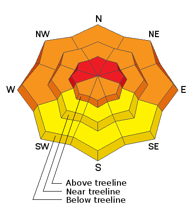
Blowing and drifting snow will cause the avalanche danger to rise to HIGH today in upper elevation, wind exposed terrain, particularly on slopes with a W-N-E aspect. Natural and human triggered avalanches are likely in these areas. At mid, and even lower elevations, the avalanche danger is CONSIDERABLE on steep, wind drifted slopes facing W-N-E, and human triggered avalanches are likely in these areas. Mid, and lower elevation, south facing terrain offers mostly MODERATE danger. Backcountry travelers today need to have excellent route finding skills and know how to stay off of, and out from under, avalanche prone terrain.

Low
Moderate
Considerable
High
Extreme
Learn how to read the forecast here


