Forecast for the Skyline Area Mountains

Brett Kobernik
Issued by Brett Kobernik on
Sunday morning, December 16, 2018
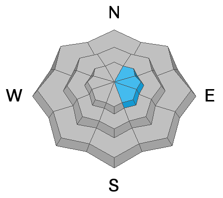
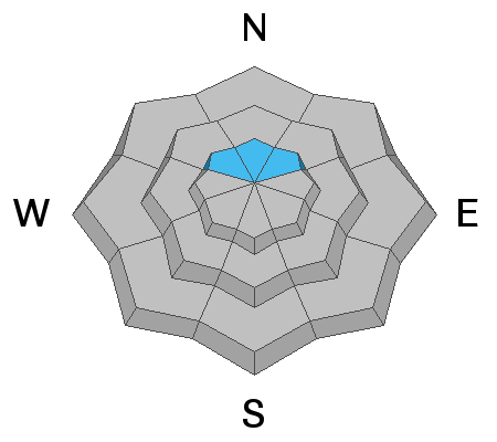
No big change since Saturday. The avalanche danger is generally LOW in most locations. There is a MODERATE avalanche danger on steep slopes above about 9500 feet in elevation that face northerly through easterly. This means HUMAN TRIGGERED AVALANCHES ARE POSSIBLE. There is a small chance that a person could trigger an easterly facing slope that's been loaded by wind drifted snow. There's also a chance that a person could trigger a deeper avalanche in the high elevation northerly facing terrain that breaks into a persistent weak layer of sugar snow near the ground.
Low
Moderate
Considerable
High
Extreme
Learn how to read the forecast here
Special Announcements
Be sure to join us at Big Pine Sports in Fairview for a free avalanche presentation on Monday, Dec 17th at 7pm. There will be food, drinks, giveaways and great deals on gear.

Check out the new FREE ONLINE AVALANCHE COURSE series developed by the Utah Avalanche Center. This is a great way to refresh your skills or prepare you for a Backcountry 101 or Level 1 class.
Weather and Snow
Our snow surface consists of dense settled creamy wind blown snow, wind crusts and sun crusts. In some areas, you'll find decent riding conditions, other areas not so much. This is mainly due to the strong northwest wind that accompanied Wednesday's little storm.
Taking a look at weather, we'll have another mostly sunny day with slightly warmer temperatures than Saturday. We'll see increasing clouds on Monday ahead of a minor weather disturbance that will move through on Monday night which will cool temperatures off but won't bring any snow. High pressure builds back in for later in the week bringing mild weather. The next storm looks like it will move through about Christmas time. It's still to early to speculate about how much snow it'll produce.
Ad
Avalanche Problem #1
Wind Drifted Snow
Type
Location
Likelihood
Size
Description
Slopes that were loaded with wind drifted snow are getting more stubborn and are less likely to release if provoked by a person. That said, I'd still avoid very steep slopes that have been loaded with wind drifted snow. These are generally east facing along the higher ridges.
Avalanche Problem #2
Persistent Weak Layer
Type
Location
Likelihood
Size
Description
A persistent weak layer of sugar snow near the ground remains a slight concern in the higher elevation more northerly facing slopes. This issue is more pronounced the higher you go in elevation. There have not been any significant recent avalanches that have broken into this weak snow near the ground. There is a very stout and strong "bridge" of snow that is on top of this layer which is all the snow since Thanksgiving. That said, I am still getting fractures and propagation in snowpit tests. I continue to avoid steep slopes in the higher elevation northerly facing terrain.