Sign Up for the Utah Snow and Avalanche Workshop (USAW) on December 7th!

Forecast for the Uintas Area Mountains

Craig Gordon
Issued by Craig Gordon on
Friday morning, March 8, 2024
On a solid, go-anywhere base, the snow feels strong and good to go... but don't get tricked into thinking all slopes are bomb dot com-
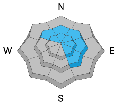
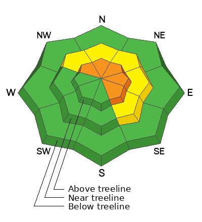
Today, expect to find pockets of CONSIDERABLE avalanche danger on wind drifted slopes, especially those in the wind zone above treeline. Human triggered avalanches are LIKELY on steep, leeward slopes, particularly those with an easterly component to their aspect. In addition... while becoming more the exception than the rule, steep, rocky, slopes with a shallow snowpack is bulls-eye terrain where you can still trigger an avalanche that breaks to old snow near the ground.
MODERATE avalanche danger exists near treeline on slopes facing the north half of the compass, where winds have swirled, forming stiff slabs. Human triggered avalanches are POSSIBLE on steep slopes with recent deposits of wind drifted snow.
LOW avalanche danger is found below treeline on shady slopes along with most terrain facing the south half of the compass.
Low
Moderate
Considerable
High
Extreme
Learn how to read the forecast here
Special Announcements
We are seeking a passionate individual to join us as Executive Director of the nonprofit Utah Avalanche Center. Click here for more information.
Weather and Snow
Nowcast- Skies cleared late last night in the wake of yesterday's storm which delivered a white, fluffy, topper. Or if ya wanna sound smart (which I'm aiming for today :)... three inches of snow with about .25" snow water equivalent. Temperatures hover in the upper teens across the board, whilst hardly a breath of northerly wind blows 5-15 mph even near the high peaks. It might not be over-the-hood, but riding and turning conditions are most excellent none-the-less.
Forecast- Get out and get after it before the sun does... it'll be a stunner with mostly sunny skies, light winds, and temperatures climbing into the upper 20's and low 30's.
Futurecast- High pressure delivers warmer temperatures and dry conditions this weekend before an unsettled pattern sets up for next week.

Recent Avalanches
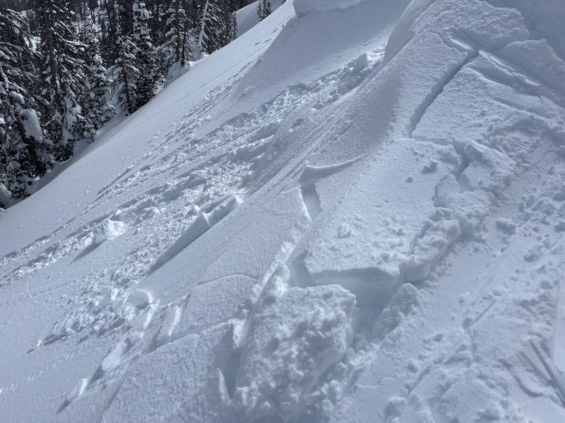
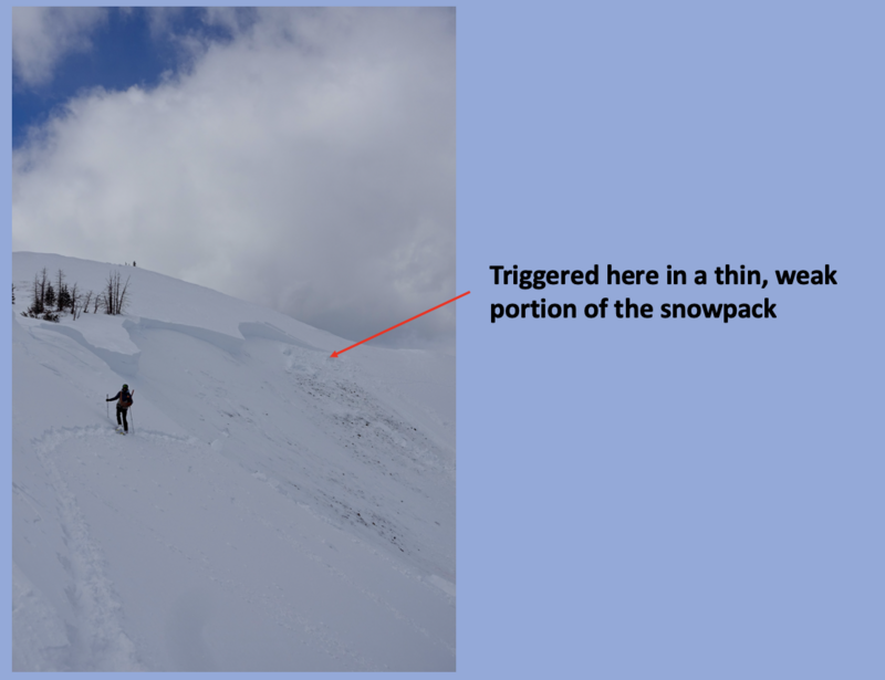
Four out of five Uinta avalanche forecasters recently surveyed agree... in the wind zone you can still trigger a deep, dangerous avalanche from a thin, shallow, rocky portion of the snowpack much like this piece of snow in Humpy Basin.

For all Uinta observations and recent avalanche activity click HERE.
Ad
Avalanche Problem #1
Wind Drifted Snow
Type
Location
Likelihood
Size
Description
Ted was in Gold Hill Wednesday and found minor cracking and shallow wind drifts near the ridges.
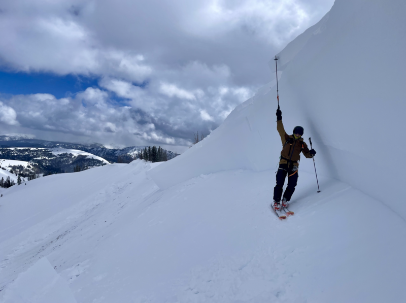
A handful of drifts on the leeward side of upper elevation ridges remain sensitive and will react to our additional weight. Nothing too alarming and easily managed by toning your slope angle down a notch or two and choosing wind sheltered terrain. You know the drill... lose the wind, you lose the problem.
Avalanche Problem #2
Persistent Weak Layer
Type
Location
Likelihood
Size
Description
Becoming more the exception than the rule, this slide triggered Wednesday broke 4'-10' deep and a football field wide. Fitting into a recent pattern, but not a tidy box, this avalanche was initiated from a thin, weak portion of the snowpack.
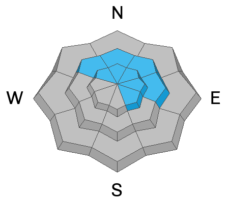
As the snowpack grows deep and more homogeneous, the odds of triggering a dangerous avalanche that breaks to weak snow near the ground diminish. But there's a disclaimer in small print, because we don't trigger scary, dangerous avalanches from deep portions of snow, rather it's from shallow, thin pieces of snow like around rocks or bushes, barely hidden under the snow surface. Whether it's from multiple avalanches or wind scouring, bulls-eye terrain is steep, rocky slopes facing the north half of the compass, especially in the wind zone where the pack has remained thin this year. And remember... last weeks cow-tipping, southerly winds transported tremendous amounts of snow to leeward slopes, adding a thick, cohesive slab on top of a structurally flawed base. All we need to do is roll along and knock the legs out from underneath and we'll be staring down the barrel of a very dangerous slide.
Additional Information
The Uinta weather station network was upgraded this summer and all that real-time info is found HERE. Simply click on "western Uinta" tab and then "weather stations" tab.

We are always looking for snow and avalanche observations or just general riding conditions. So... if you see something, say something. You can reach me directly at craig@utahavalanchecenter.org or 801-231-2170.
Also, if you're looking for more avy education opportunities for yourself, your crew, or your club please don't hesitate to reach out to me and we'll find a presentation, class, or clinic for ya!
General Announcements

Issued at 03:30 on Friday, March 8th this forecast will be updated by 0700 Saturday, March 9th, 2024.
This forecast is from the U.S.D.A. Forest Service, which is solely responsible for its content. This forecast describes general avalanche conditions and local variations always occur.