Forecast for the Uintas Area Mountains

Craig Gordon
Issued by Craig Gordon on
Saturday morning, March 13, 2021
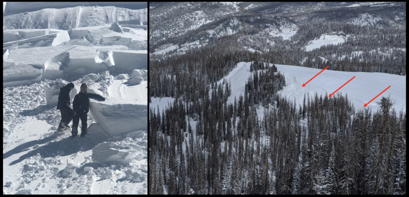
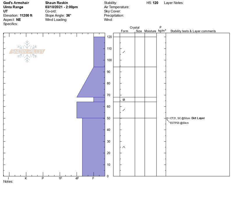
Heads up... a solid shot of snow and wind leads to rising avalanche danger today, especially for the east side of the range where the snowpack is unusually weak and fragile.
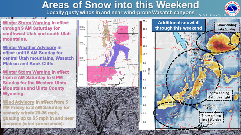
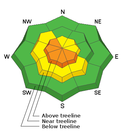
In upper elevation terrain, especially in the wind zone at and above treeline, you'll find CONSIDERABLE avalanche danger on steep wind drifted slopes and HUMAN TRIGGERED AVALANCHES ARE LIKELY, particularly on slopes facing the south half of the compass and especially on slopes with a westerly component to its aspect. While more the exception than the rule, any avalanche that breaks to weak layers of snow near the ground will result in a deep, dangerous avalanche that'll instantly ruin your day.
Strong winds penetrate mid elevation terrain and you'll find MODERATE avalanche danger. Human triggered avalanches are POSSIBLE on steep wind drifted slopes.
Low elevation terrain wind sheltered terrain offers generally LOW avalanche danger. Remember- low avalanche danger doesn't mean no avalanche danger, so please continue practicing your safe travel rituals and make sure you carry and know how to use your avalanche rescue gear.... transceiver, shovel, and probe.
Low
Moderate
Considerable
High
Extreme
Learn how to read the forecast here
Weather and Snow
Nowcast-
A cold winter storm churns away in the four corners and that'll crank up northeast winds and deliver a solid shot of snow. As a matter of fact, light snow began falling at 01:00 with just about 2" stacking up so far. The bigger news are the northeast winds which began ramping up right around midnight and now blast 30-40 mph along the high ridges. Temperatures are in the mid teens and low 20's. Today's wind is gonna nuke our big open bowls, so mid and low elevation, wind sheltered terrain is the ticket.
Forecast-
Wrap around moisture stacks up nearly a foot of snow today, whilst northeast winds crank in the 30's and 40's along the high ridges. Temperatures climb into the upper 20's and overnight lows dip into the teens.
Futurecast-
Dry and warming for Sunday with diminishing winds.

Looking for real-time temps, snow, or wind?
Click here and then on the "western Uinta" tab for western Uinta specific, weather station network.
Recent Avalanches
No significant avalanche activity to report

Observations, trip reports, and avalanches found here.
Ad
Avalanche Problem #1
Wind Drifted Snow
Type
Location
Likelihood
Size
Description
The image above reflects a bump in the winds early this morning at the Lofty Lake Peak wind site at 11,186'
East and northeast winds crank along the high ridges and with no shortage of light density snow to work with, they'll easily whip up a fresh batch of drifts sensitive to our additional weight. Strong winds aren't unusual for the Uinta ridgelines... it's where wind was invented... what's unusual is the east-northeast direction. Today, you'll want to look for and avoid steep wind drifted slopes facing the south half the compass, particularly slopes with a westerly component to its aspect. Remember, fresh drifts are forming on slick sun crusts and todays avalanches may run further and faster than you might expect.
Avalanche Problem #2
Persistent Weak Layer
Type
Location
Likelihood
Size
Description
Avalanches can still break deep and wide. This hard slab triggered Sunday on the Hoyt Peak shoulder is a sizable chunk of snow that broke 4'-6' deep x 400' wide, but due to the terrain characteristics, only ran about 100' vertical.
The good news is... where the snowpack is deep, it's happy in its own skin. However, snow is a curious medium and all we need to do is find one inconsistency or a shallow zone, maybe around a rock or bush, collapse the pack, and now we've got a bigger slide than we might've bargained for. So my safe travel strategy is to think about suspect terrain I want to continue avoiding and that includes steep, rocky terrain and slopes that avalanched near the ground earlier in the season. And here's something to consider... we've got a "go anywhere" base, so if you're getting into steep, technical terrain, remember that even a small slide can knock you off your ride, slam you into a tree, and throw a curve ball at your day.
Shaun and Weston D traveled into the big, alpine terrain near Bald Mountain and found a snowpack making its best attempt to get stronger. And while we appreciate the sincere efforts the snowpack is making, gains don't come easy and it may be a little too late in the season for the pack to build up the strength it needs to totally turn the corner. More on Shaun and Weston's travels found HERE.
Additional Information
I will update this forecast by 7:00 AM tomorrow, Sunday, March 14th.
Your observations are important, so please let me know what you're seeing... click HERE and contribute to this amazing community based program
General Announcements
If you see or trigger an avalanche or just wanna let me know what you're seeing you can reach me directly at 801-231-2170 or craig@utahavalanchecenter.org
This forecast is from the U.S.D.A. Forest Service, which is solely responsible for its content. This forecast describes general avalanche conditions and local variations always occur.