Forecast for the Uintas Area Mountains

Craig Gordon
Issued by Craig Gordon on
Tuesday morning, February 25, 2025
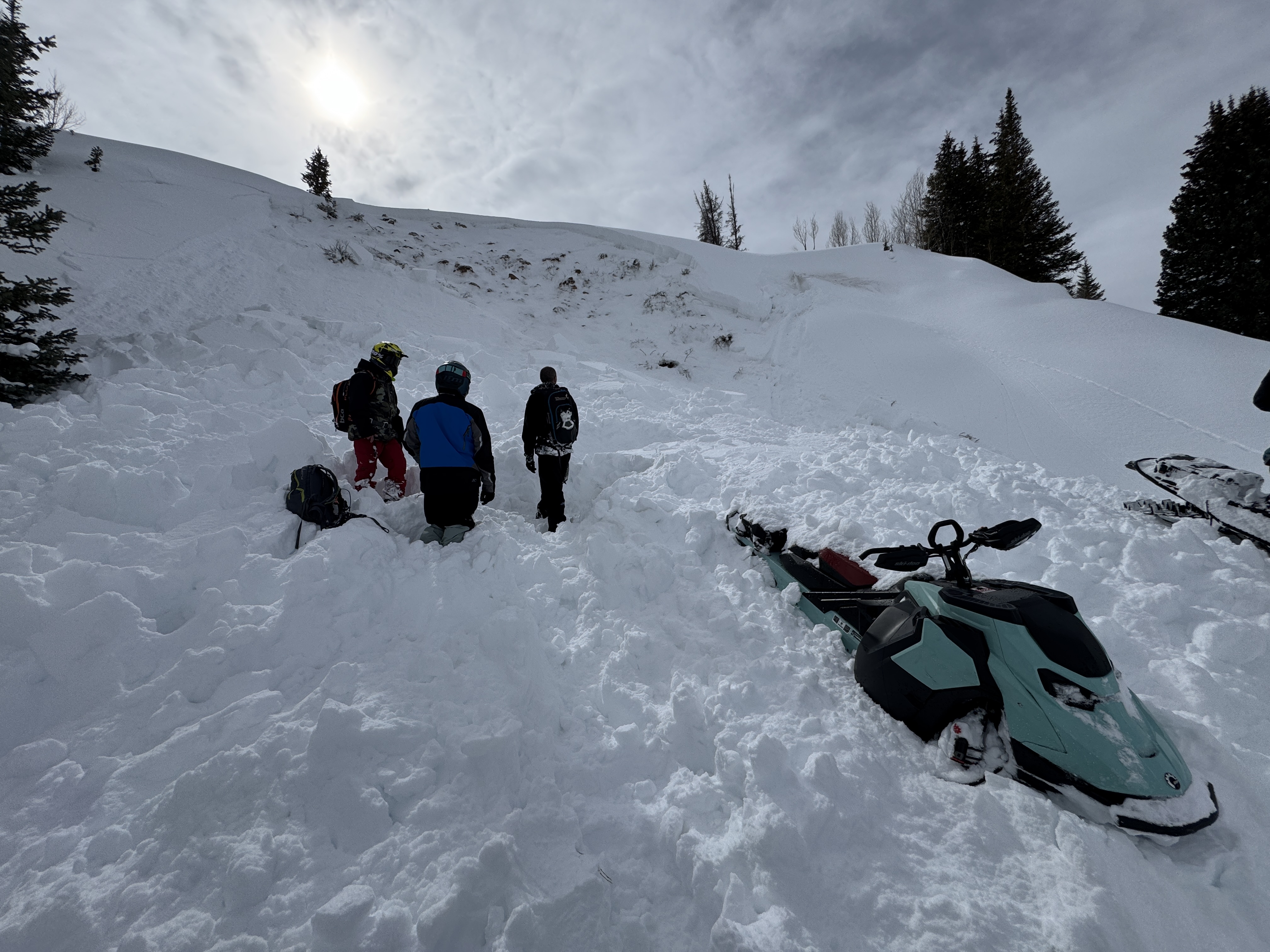
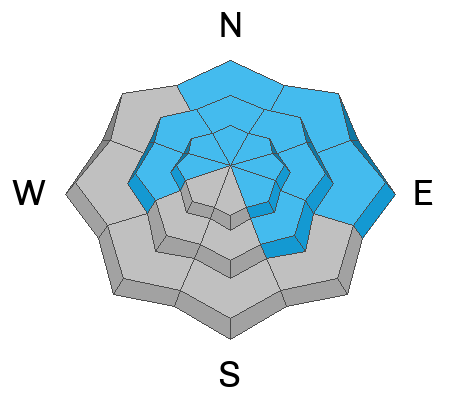
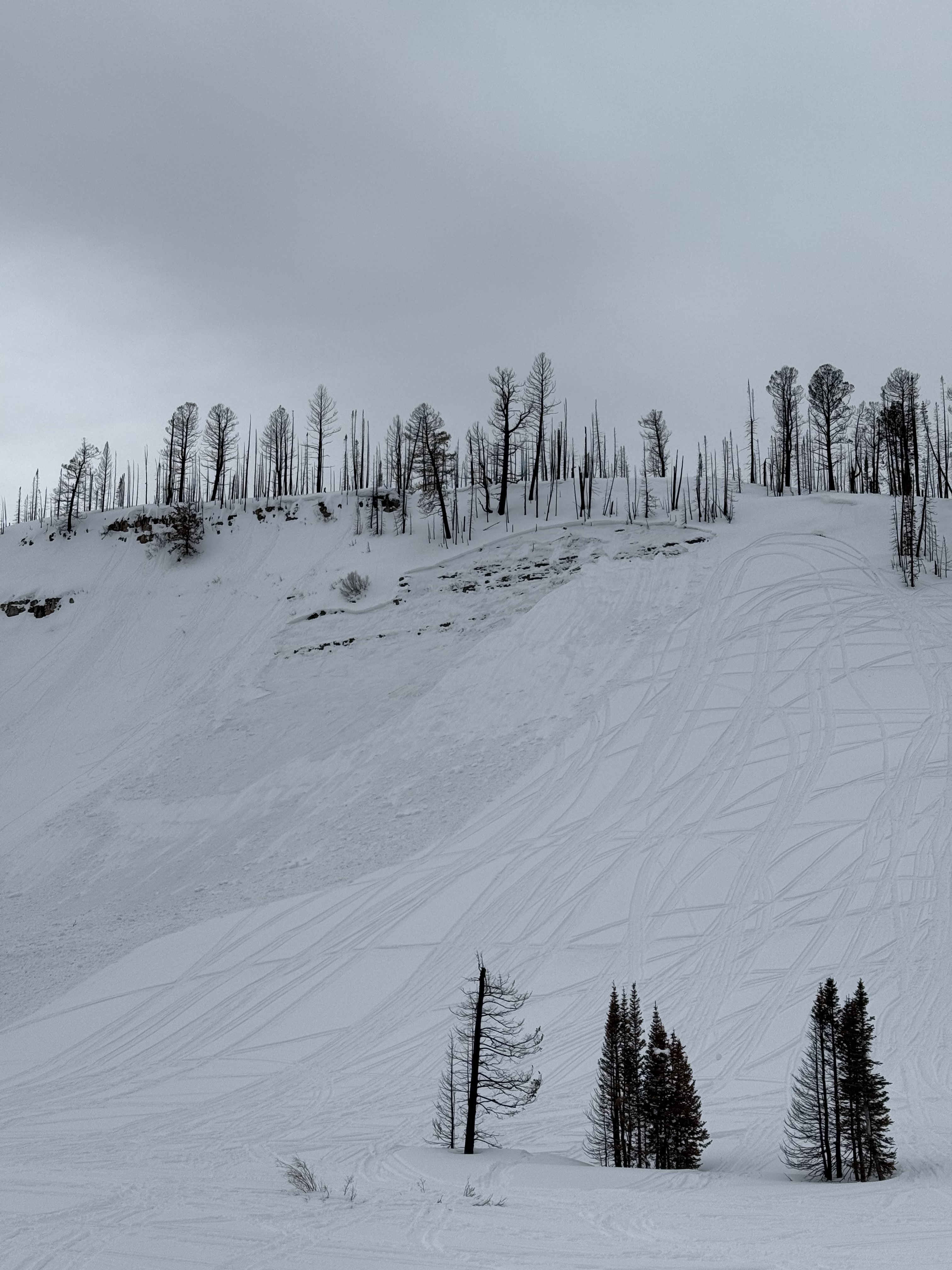
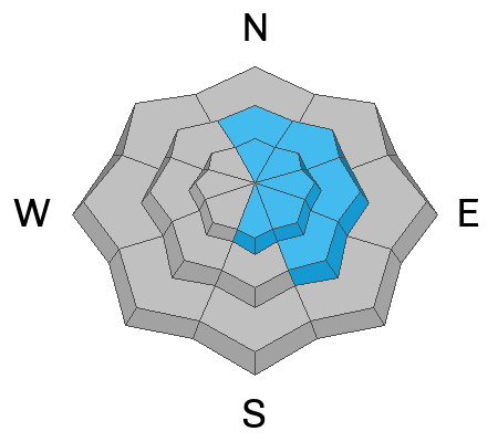
Expect to find CONSIDERABLE avalanche danger on mid and upper elevation slopes facing the north half of the compass where it is LIKELY we can trigger persistent slab avalanches breaking 3'-6' deep, failing on faceted snow, breaking deeper than we might expect. In addition, MODERATE danger exists on steep, leeward slopes at mid and upper-elevations where human triggered wind drifts are POSSIBLE.
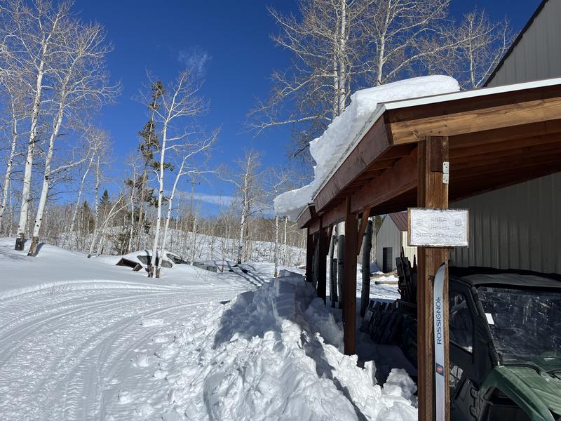
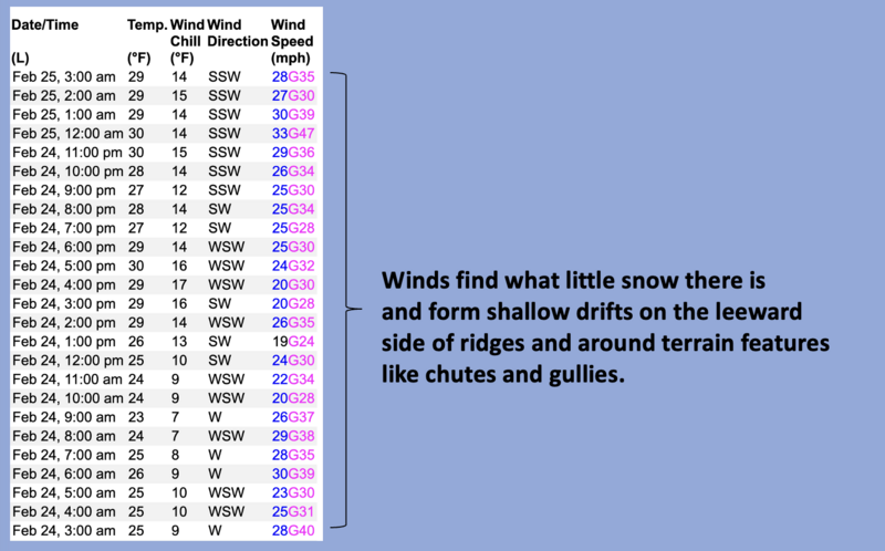
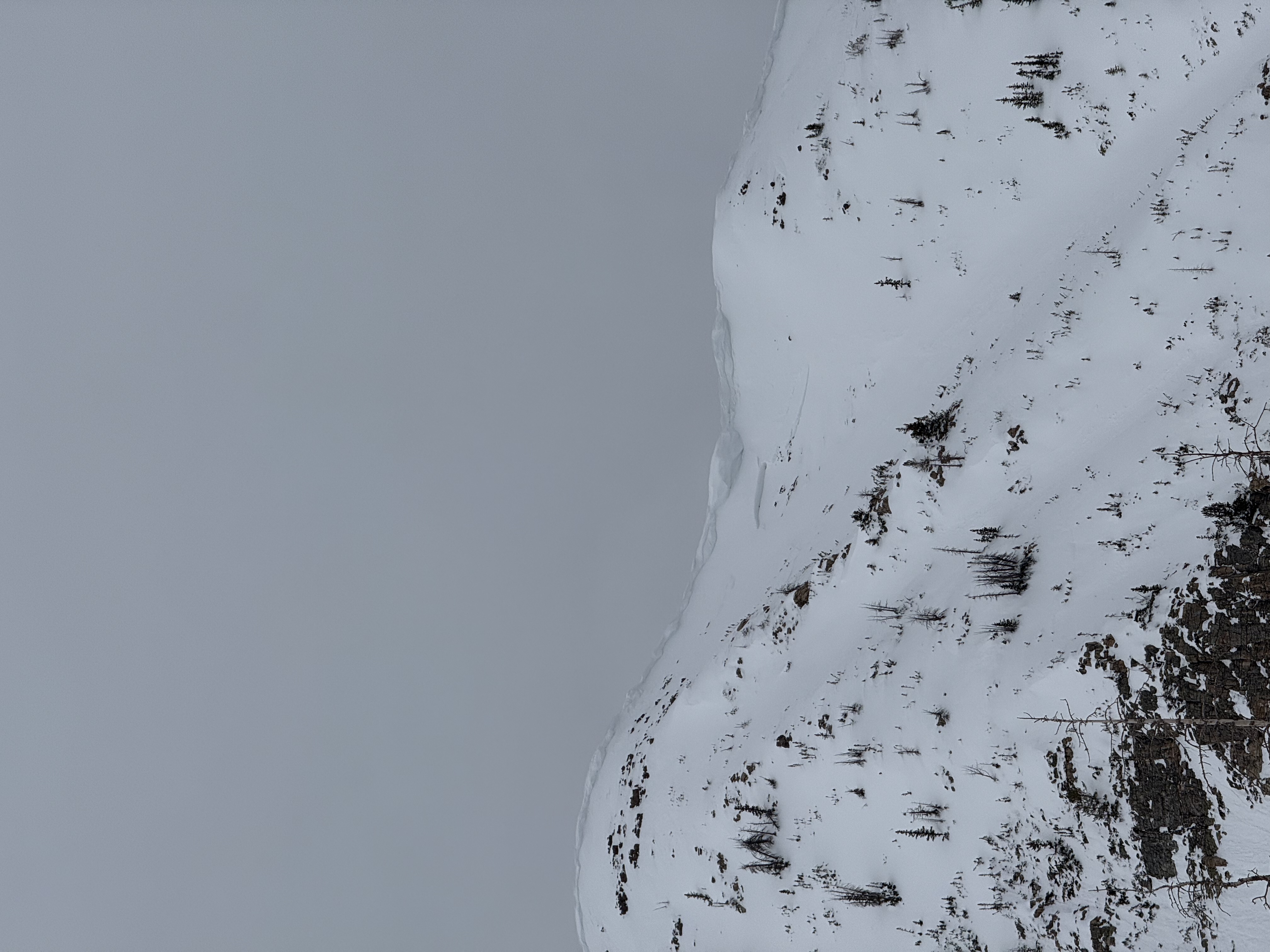
Recent avy activity confirms the hazard is real so I'm sticking with the strategy of avoiding slopes with a persistent weak layer all together. But no worries, great riding is found on low angle slopes in protected terrain out of the windzone where the riding is stellar and the livin' is easy.
Low
Moderate
Considerable
High
Extreme
Learn how to read the forecast here
Weather and Snow
Nowcast- High clouds drift into the Uinta zone early this morning, ushering cooler weather and a scattered snow shower or two. Current temperatures kick off the day in the mid to upper 30's whilst southwest winds blow in the mid 30's near the high peaks.
Forecast- Today's weak cool front slides through in the next few hours and we see partly cloudy skies by suppertime. We've reach our high temperature for the day and the mercury begins diving into the upper 20's by about midday, dipping into the teens overnight. West and northwest winds ramp into the 40's are gonna be a nuisance near the high ridges
Futurecast- Expect drier conditions throughout most of the upcoming week as high pressure becomes the dominant feature. The next potentially reasonable chance for snow is slated for late in the weekend or early next week, though the jury's still out on this one.
Ted was in the Whitney Basin yesterday and notes that riding an turning conditions remain reasonable, but recent warm temperatures have roofs shedding their winter coats.
Recent Avalanches
No shortage of recent avalanches this weekend. From the North Slope to the south half of the range, multiple, human triggered slides were reported, ending with a close call near the Buck Knoll. Here, a rider got his rig stuck on the steep, burly little slope and as his partner came to assist, triggered a pockety avalanche packing a punch. Check out the great video and detailed report, here -- Thank you for sharing!
In addition, check out intel from across the range and beyond, here.
Avy recap... a north facing slope at 8,500' dumped all of its snow onto a bench feature (terrain trap) where this weekend's close call occurred. The crew was lucky, but did the right thing... had eyes on their partner and were at the ready to assist when the slide was triggered and after the dust cleared.
Ad
Avalanche Problem #1
Persistent Weak Layer
Type
Location
Likelihood
Size
Description
Andy explaining how the avalanche sausage was made on a recently triggered slide near Duchesne Ridge.
Mid and upper elevation terrain facing west through north through southeast are prime time slopes for harboring a complicated snowpack with multiple persistent weak layers, and they really showed their teeth this weekend. In fact, riders triggered large and small avalanches on this set of problematic weak layers, now buried 2-4' beneath the snow surface.
The past few days showcased our problem child with riders triggering large avalanches from a distance, wiping clean the entire seasons snowpack, even on slopes with a hundred tracks out it. Here's where it gets tricky... we're not seeing the usual red flags like cracking and collapsing, but recent avalanches are natures freebie and the biggest sign of unstable snow. I steer clear of this unpredictable avalanche dragon by opting to ride non-avalanche, polar terrain with no overhead hazard. I'm finding cold snow and straight-forward avy hazard, whilst reducing my stress to the mess of triggering a big avalanche. Done... done.... and done.
This avalanche from Soapstone Mountain broke on a shallow, rocky, east facing slope at 9,800'. Tracks on a slope don't mean it's good to go. Whether it's on the first pull or the hundredth, all we need to do is find the sweet spot like near a bush or shallowly buried rock, collapse the pack (whoomph) and now we're off to the races with the roof crashing down on us.
Avalanche Problem #2
Wind Drifted Snow
Type
Location
Likelihood
Size
Description
24 hour data dump from Windy Peak (10,662') illustrates recent winds.
West and southwest winds have blown for 48 hours, creating both soft and hard wind drifts on the north half of the compass at mid and upper-elevations. Today's wind drifts are a bigger brother version of yesterday's slabs, but generally breaking 1'-2' deep and potentially more reactive to our additional weight. Look for and avoid fat, rounded pillows of snow and listen for slopes that sound hollow like a drum.
As sledders we don't think about windslabs quite as dangerous as a skier or boarder might see 'em, but remember... any piece of snow, no matter the size, can knock us off our feet, drag us into a terrain trap or consequential terrain, and make for a bad ending to the story. This is a straight-forward avalanche problem managed by simply seeking out wind sheltered terrain.
A fat chunk of wind-drifted snow most likely triggered with cornice fall, on an east facing, upper elevations slope at 11,000' off the Mirror Lake Corridor.
General Announcements
We are always looking for snow and avalanche observations or just general riding conditions. In the meantime reach out to us with questions, concerns, or if you see anything in your travels! Contact us directly through the info below:
  • Craig Gordon | Craig@utahavalanchecenter.org, 801-231-2170, or
  • Andrew Nassetta | Andy@utahavalanchecenter.org, 860-460-8142.
This forecast is from the U.S.D.A. Forest Service, which is solely responsible for its content. This forecast describes general avalanche conditions and local variations always occur. This forecast was issued on Tuesday, February 25th at 03:30 AM and expires 24 hours after it was issued.